Detalles
Lugar de impresión
Venezia
Grabadores
MAGINI Giovanni Antonio
Descripción
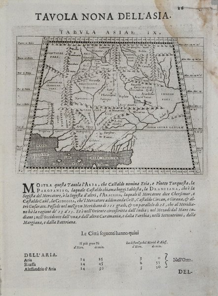
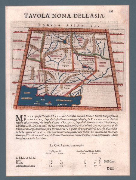
Mappa su proiezione trapezoidale, basata sul lavoro sia di Tolomeo che di Giacomo Gastaldi; presenta, inoltre, una forte somiglianza con la mappa di Sebastian Munster della stessa regione datata 1540. La carta è incentrata sull'Iran orientale, il Pakistan e l'Afghanistan come erano conosciuti in epoca tolemaica, coprendo la regione tra l'antica Partia e la valle del fiume Indo e tra Herat e l'Oceano Indiano. Le regioni montuose dell'Iran occidentale sono disegnate in modo straordinariamente accurato, così come il sistema del fiume Indo e il suo delta dove sfocia nel Mar Arabico vicino a Karachi. Molti nomi di luoghi sono indicati come lo erano da Tolomeo nell'antichità. Carta geografica tratta dalla ' Geografia cioè descrittione universale della Terra ' di Claudio Tolomeo curata dal Magini, per la prima volta stampata a Venezia nel 1596, presso gli Eredi di Simon Galignani de Karera. La raccolta maginiana contiene 64 incisioni in rame finemente intagliate da Girolamo Porro e fu poco dopo copiata da Petrus Keschedt, un editore di Colonia (le mappe delle due edizioni sono pressoché indistinguibili).Una successiva ristampa del lavoro di Magini, con la traduzione di Leonardo Cernoti dal testo latino, venne stampata a Padova dai fratelli Galignani nel 1621. ' Con l’ultima, postuma, edizione maginiana della ' Geografia ' “the long series of editions of Ptolemy’s Geography, revised and extended as text books of modern geography, seems to have come to an end” (Stevens, 1972, p. 22). Incisione in rame, finemente colorata a mano, in ottimo stato di conservazione. Magini's map on trapezoidal projection, based on the work of both Ptolemy and Giacomo Gastaldi, and bears a strong resemblance to Munster’s map of the same region dated 1552. ' The map focuses on eastern Iran, Pakistan and Afghanistan as they were known in Ptolemaic times, covering the region between ancient Parthia and the Indus River valley, and between Herat and the Indian Ocean. The mountainous regions of western Iran are remarkably accurately drawn as is the Indus River system and its delta where it empties into the Arabian Sea near Karachi. Many place names are denoted as they were by Ptolemy in antiquity. Map taken from the ' Geografia cioè descrittione universale della Terra ' ' of Claudio Tolomeo by Giovanni Antonio Magini, first printed in Venice in 1596, at the Heirs of Simon Galignani de Karera.The Maginian collection contains 64 copper engravings finely carved by Girolamo Porro and was soon copied by Petrus Keschedt, a publisher from Cologne (the maps of the two editions are almost indistinguishable). ' A subsequent reprint of Magini's work, with the translation by Leonardo Cernoti from the Latin text, was printed in Padua by the Galignani brothers in 1621. With this edition of the ' Geografia ' “the long series of editions of Ptolemy’s Geography, revised and extended as text books of modern geography, seems to have come to an end” (Stevens, 1972, p. 22). Etching with fine later hand colour, in excellent condition. Cfr.

 Descubre cómo utilizar
 Descubre cómo utilizar