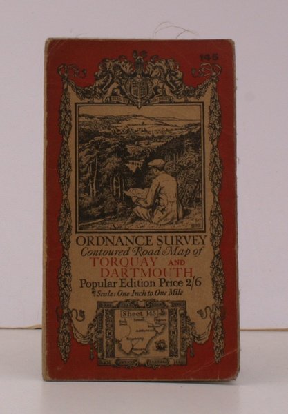
Ordnance Survey Contoured Road Map of Torquay and Dartmouth. Sheet 145. Popular Edition. Scale: One Inch to to One Mile. GOOD, FIRM COPY
Ordnance Survey Contoured Road Map of Torquay and Dartmouth. Sheet 145. Popular Edition. Scale: One Inch to to One Mile. GOOD, FIRM COPY | Livres anciens et modernes | Ordnance Survey
Livres anciens et modernes
Ordnance Survey
Ordnance Survey, Southampton,
1926
18,40 €
(Devon,
Royaume-Uni)
Mode de Paiement
- PayPal
- Carte bancaire
- Virement bancaire
- Pubblica amministrazione
- Carta del Docente
Détails
- Année
- 1926
- Auteur
- Ordnance Survey
- Éditeurs
- Ordnance Survey, Southampton
- Thème
- topography, cartography, maps, ordnance survey, torquay, dartmouth, ellis martin
- Langues
- Anglais
Description
Folding coloured map on cloth measuring 21 x 30 ins (approx. 53.0 x 76.0 cms) folding in 24 panels to 7.0 x 4.0 ins (approx. 17.7 x 10.1 cms); original pictorial card wrappers, light wear to folds else a bright, clean copy. The famous Popular Edition One Inch series with striking 'cyclist' artwork by Ellis Martin was first issued in 1919. This is the 1926 revision. The covers are black with red sheet name and location map. Browne, 11.1.a
