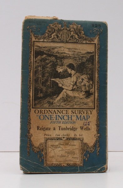
Ordnance Survey One-Inch Map. Fifth Edition. Reigate & Tunbridge Wells. Sheet 125.
Ordnance Survey One-Inch Map. Fifth Edition. Reigate & Tunbridge Wells. Sheet 125. | Livres anciens et modernes | Ordance Survey
Livres anciens et modernes
Ordance Survey
Ordnance Survey, [Southampton,
1938
Ordnance Survey One-Inch Map. Fifth Edition. Reigate & Tunbridge Wells. Sheet 125.
Ordnance Survey One-Inch Map. Fifth Edition. Reigate & Tunbridge Wells. Sheet 125. | Livres anciens et modernes | Ordance Survey
Livres anciens et modernes
Ordance Survey
Ordnance Survey, [Southampton,
1938
11,50 €
(Devon,
Royaume-Uni)
Mode de Paiement
- PayPal
- Carte bancaire
- Virement bancaire
- Pubblica amministrazione
- Carta del Docente
Détails
- Année
- 1938
- Auteur
- Ordance Survey
- Éditeurs
- Ordnance Survey, [Southampton
- Thème
- topography, kent, surrey, sussex, reigate, redhill, crawley, east grinstead, sevenoaks, tunbridge wells, wadhurst, rotherfield, ordnance survey, maps, ellis martin, cartography, ordance survey, topography, maps, ordnance, survey, one-inch, map
- Langues
- Anglais
Description
Large folding map on cloth measuring 22.5 x 33.5 ins (approx. 57.0 x 85.0 cms) folding in 24 panels to 7.5 x 4.25 ins (approc. 19.0 x 11.0 cms), some light age-soiling; original pictorial wrapper, folded as issued, covers mildly browned and scuffed else a good, sound copy. With Ellis Martin's well-known 'hiker' illustration on cover, and the trade ticket of Roffey & Clarke of Croydon on rear wrapper. First revision of the original issue of 1936. OS print code 6038. Hellyer 23.2.a
