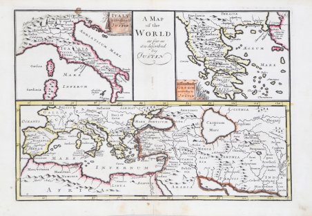
A Map of the World as far as it is described by Justin
A Map of the World as far as it is described by Justin | Gravures | BROWNE C.
Gravures
BROWNE C.
1712


A Map of the World as far as it is described by Justin
A Map of the World as far as it is described by Justin | Gravures | BROWNE C.
Gravures
BROWNE C.
1712
450,00 €
(Roma,
Italie)
Mode de Paiement
- PayPal
- Carte bancaire
- Virement bancaire
- Pubblica amministrazione
- Carta del Docente
Détails
- Année
- 1712
- Lieu d'édition
- Londra
- Format
- 235 X 165
- Graveurs
- BROWNE C.
- Description
- Zacharakis C. G. "A Catalogue of Printed Maps of Greece 1477 - 1800" (2009), n. 738
Description
Carta geografica del Mediterraneo con due cartigli contenenti la carta dell'Italia e della Grecia. Incisione in rame, coloritura coeva dei contorni, in ottimo stato di conservazione. Rarissima. Chart of the mediterranean sea with two carouches containing Italy and Greece. Copperplate, contemporary outline colour, in excellent condition. Very rare. Cfr. Zacharakis C. G. "A Catalogue of Printed Maps of Greece 1477 - 1800" (2009), n. 738
