Accurater Prospect und Grundris der Konigl Gros Britanisch Haupt und Residenz Stadt London
Accurater Prospect und Grundris der Konigl Gros Britanisch Haupt und Residenz Stadt London | Gravures | HOMANN EREDI
Accurater Prospect und Grundris der Konigl Gros Britanisch Haupt und Residenz Stadt London
Accurater Prospect und Grundris der Konigl Gros Britanisch Haupt und Residenz Stadt London | Gravures | HOMANN EREDI
Mode de Paiement
- PayPal
- Carte bancaire
- Virement bancaire
- Pubblica amministrazione
- Carta del Docente
Détails
- Année
- 1740
- Lieu d'édition
- Norimberga
- Graveurs
- HOMANN EREDI
Description
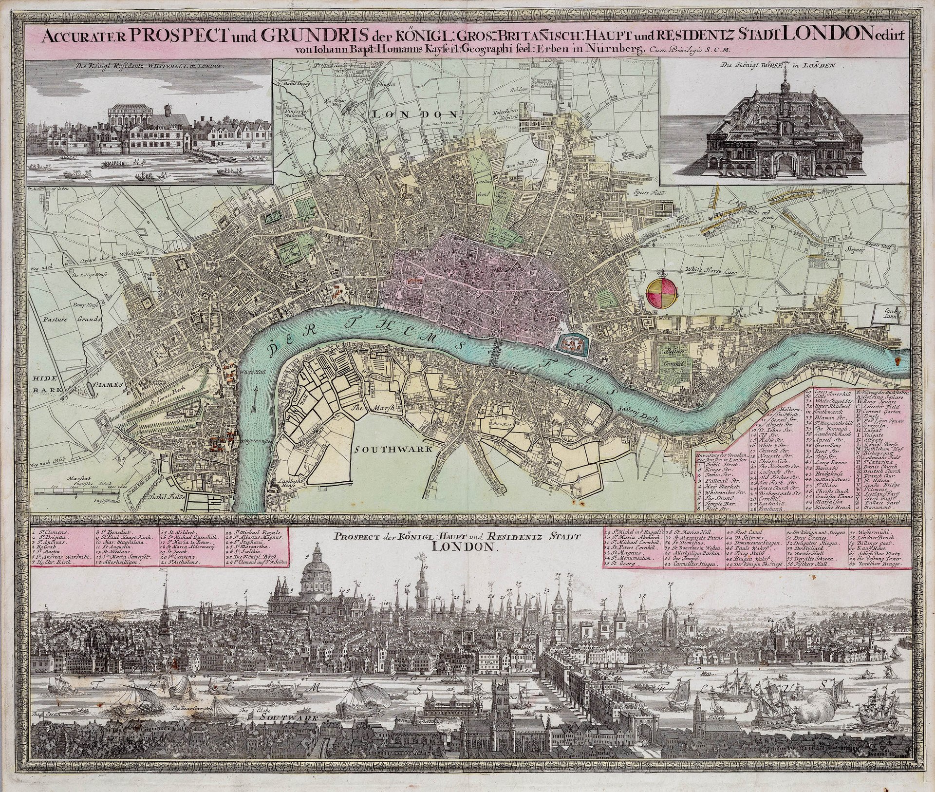
Incisione in rame, mm 495x580, dipinta d'epoca. Bellissimo esemplare. Decorativa pianta arricchita da una serie di vedute di Londra all'inizio del XVIII secolo. La mappa si estende fino alla periferia nord di Londra e include vedute decorative dei palazzi reali: Windsor, Hampton Court, Kensington, il King's Hospital a Chelsea e il King's Hospital a Greenwich. Homann basa queste vedute su tavole individuali più grandi di Johannes Kip che erano state pubblicate nel suo libro sulle vedute britanniche. La mappa si estende da Windsor a ovest fino a Dagenham a est, e da Norwood a sud fino a South Mimms a nord. <BR>Johann Baptist Homann (1663-1724) era un cartografo che fondò la famosa casa editrice Homann Heirs. Ha vissuto tutta la sua vita in Baviera, in particolare a Norimberga. Inizialmente, Johann si formò per diventare sacerdote prima di convertirsi al protestantesimo e lavorare come notaio. Nel 1702, Johann fondò una casa editrice specializzata in incisioni. L'azienda prosperò, diventando il principale editore di mappe in Germania e un'entità importante nel mercato europeo delle mappe. Nel 1715, Johann fu nominato geografo imperiale del Sacro Romano Impero da Carlo VI e divenne membro dell'Accademia Prussiana delle Scienze. Johann è famoso soprattutto per il suo "Grosser Atlas über die ganze Welt". Dopo la morte di Johann nel 1724, l'attività passò al figlio Christoph (1703-1730). Alla morte prematura di Christoph, l'azienda passò agli eredi successivi e il nome dell'azienda cambiò in Homann Erben, ovvero Eredi Homann. L'azienda continuò la sua attività fino al 1848.<BR>Copper engraving, 495x580 mm, painted in period style. Beautiful specimen. Decorative map enriched with a series of views of London at the beginning of the 18th century. The map extends to the northern suburbs of London and includes decorative views of the royal palaces: Windsor, Hampton Court, Kensington, the King's Hospital in Chelsea, and the King's Hospital in Greenwich. Homann based these views on larger individual plates by Johannes Kip that had been published in his book on British views. The map extends from Windsor in the west to Dagenham in the east, and from Norwood in the south to South Mimms in the north. Johann Baptist Homann (1663-1724) was a cartographer who founded the famous publishing house Homann Heirs. He lived his entire life in Bavaria, specifically in Nuremberg. Initially, Johann trained to become a priest before converting to Protestantism and working as a notary. In 1702, Johann founded a publishing house specializing in engravings. The company prospered, becoming the leading publisher of maps in Germany and an important entity in the European map market. In 1715, Johann was appointed imperial geographer of the Holy Roman Empire by Charles VI and became a member of the Prussian Academy of Sciences. Johann is best known for his "Grosser Atlas über die ganze Welt" (Great Atlas of the Whole World). After Johann's death in 1724, the business passed to his son Christoph (1703-1730). Upon Christoph's premature death, the company passed to subsequent heirs and the company name changed to Homann Erben, or Homann Heirs. The company continued its activities until 1848.<BR>
