Africa XVIII Nova Tabula
Africa XVIII Nova Tabula | Gravures | Münster Sebastian

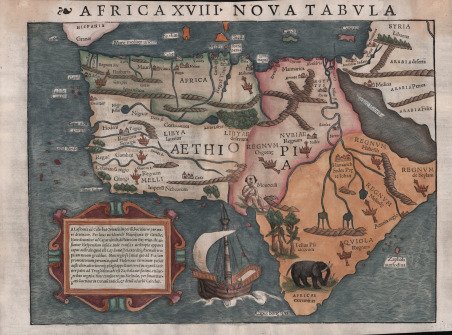

Africa XVIII Nova Tabula
Africa XVIII Nova Tabula | Gravures | Münster Sebastian
Mode de Paiement
- PayPal
- Carte bancaire
- Virement bancaire
- Pubblica amministrazione
- Carta del Docente
Détails
- Année
- 1542
- Lieu d'édition
- Basilea
- Format
- 395 X 285
- Graveurs
- Münster Sebastian
Description
Primo stato, seconda tiratura, della “the earliest, readily available, printed map to show the entire continent of Africa” (Betz). Dall'edizione latina Geographia Universalis di Munster, stampata a Basilea nel 1542. Riccamente evocativa del periodo iniziale, è abbellita da un galeone a vele spiegate, un elefante relativamente realistico, pappagalli e un ciclope. La mappa è basata in parte su fonti tolemaiche, in parte portoghesi e in parte arabe" (Tooley), e la forma complessiva del continente è stata derivata manoscritti portoghesi. Betz ritiene che una fonte per la descrizione dell'interno del Nordafrica possa essere stata la Descrittione dell'Africa, un manoscritto di Al Hassan (Leo Africanus) nel 1526. Questa importantissima carta rappresenta una delle prima carte a stampa dell'intero continente africano. Africa XVIII, Nova Tabula, è una fantastica sinergia visiva di immaginazione arcaica ed esplorazione recente. La forma complessiva del continente è abbastanza ben definita, essendo stata ampiamente esplorata dai portoghesi fin dai tempi del principe Enrico il Navigatore, a metà del XV secolo. Forse in tal senso possiamo intendere la rappresentazione di una caravella portoghese nella parte inferiore della mappa. I vari regni africani sono indicati dai simboli pittorici della corona e dello scettro. Secondo la tradizione tolemaica, il Nilo ha la sua sorgente in una serie di laghi che si trovano ai piedi delle misteriose Montagne della Luna. La terra intorno al Capo di Buona Speranza, in Sudafrica, è abbellita dall'apparizione di un elefante, mentre i pappagalli esotici occupano gli alberi in Angola. L’elemento più originale della mappa è la divertente rappresentazione, vicino alla costa dell'Africa orientale, di una figura denominata “Monoculi”, una popolazione con un occhio che veniva immaginata dagli scrittori classici. Münster fu un brillante polimatico, uno dei più importanti intellettuali dell'epoca rinascimentale. Negli anni Trenta del Quattrocento si dedicò alla traduzione della Geographia di Tolomeo, aggiungendo nuovo materiale relativo alle nuove terre scoperte in Africa, nelle Americhe e in Asia. Il risultato fu la pubblicazione della sua apprezzata Geographia Universalis, stampata per la prima volta nel 1540 a Basilea. La presente carta proviene dalla seconda edizione, ma rappresenta ancora il primo stato della carta, poiché lo stesso blocco di legno inalterato della prima stampa fu utilizzato per la produzione della seconda edizione. Xilografia, con bellissima coloritura a mano, piccoli difetti alla piega centrale verticale perfettamente restaurati, per il resto in ottimo stato di conservazione. Bibliografia Betz, Mapping of Africa, n. 3 variant 2; Norwich, O.I. Maps of Africa, Map 2; Tooley, The Printed Maps of the Whole of the Continent of Africa, Part 1 (1500-1600), n. 6. The first state, second issue of “the earliest, readily available, printed map to show the entire continent of Africa” (Betz). From Munster’s Geographia Universalis Latin edition of 1542. Richly evocative of its early period, it is embellished with a galleon in full sail, a relatively realistic elephant, parrots, and a Cyclops. The map "is based partly on Ptolemaic, partly on Portuguese and partly on Arabic sources" (Tooley), the overall shape of the continent having been derived from the Portuguese. Betz believes “a source for the interior of North Africa may have been the Descrittione dell‘Africa written in manuscript by al Hassan (Leo Africanus) in 1526).” As would be the case with virtually all 16th and 17th century maps of Africa, Munster’s depiction of the Nile and its headwaters follows that of Ptolemy, with the source of the White Nile presented as two lakes fed by streams emanating from Ptolemy’s Mountains of the Moon. In approximate accord with reality, another lake is shown as the source of the Blue Nile (though considerably to the south of Lake Tana). This highly important map represents the earliest reasonably obtainable map to depict the entire continent of Africa. Africa XVIII, Nova Tabula, is a fantastic visual synergy of archaic imagination and recent exploration. The overall shape of the continent is quite well defined, having been extensively explored by the Portuguese since the time of Prince Henry the Navigator in the mid-fifteenth-century, a point highlighted by the appearance of a caravel in the lower part of the map. Africa's various kingdoms are denoted by pictorial symbols of a crown and sceptre. Following Ptolemaic tradition, the Nile has its source in a series of lakes that lie at the foot of the mysterious Mountains of the Moon. The land around the Cape of Good Hope in South Africa is embellished by the appearance of an elephant, and exotic parrots occupy trees in Angola. Most amusingly, near the coast of east Africa, the "Monoculi," or one-eyed man imagined by Classical writers sits in wait for some hypothetical European visitor. Münster was a brilliant polymath and one of the most important intellectuals of the Renaissance era. Educated at Tübingen, his surviving college notebooks, Kollegienbuch, reveal a mind of insatiable curiosity, especially with regards to cosmography. Münster later became a professor of Hebrew at Heidelberg, and then from 1529 at the University of Basle. In the 1530s, he turned his attentions to translating Ptolemy's Geography, adding new material that related to the lands newly discovered in Africa, the Americas and Asia. The result was the publication of his highly regarded Geographia Universalis, first printed in 1540. The present map is from the second edition, but still represents the first-state of the map, as the same unaltered woodblock from the initial printing was employed in the production of the second edition. Woodcut, with later hand colour, small defects at vertical center fold perfectly restored, otherwise in excellent condition. Bibliografia Betz, Mapping of Africa, n. 3 variant 2; Norwich, O.I. Maps of Africa, Map 2; Tooley, The Printed Maps of the Whole of the Continent of Africa, Part 1 (1500-1600), n. 6. Cfr.
