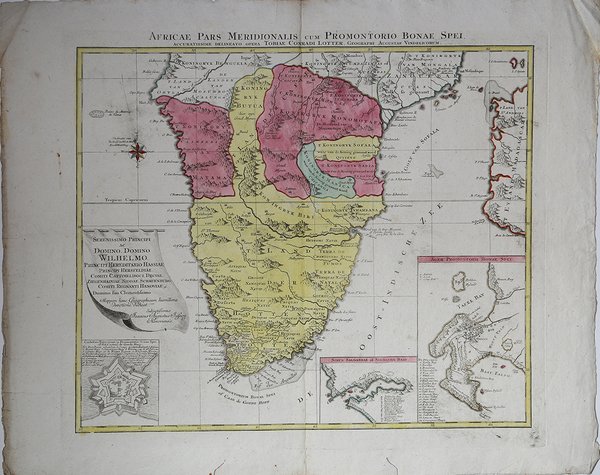
Africae Pars Meridionalis cum Promontorio Bonae Spei,…
Africae Pars Meridionalis cum Promontorio Bonae Spei,… | Gravures | LOTTER Tobias Conrad

Africae Pars Meridionalis cum Promontorio Bonae Spei,…
Africae Pars Meridionalis cum Promontorio Bonae Spei,… | Gravures | LOTTER Tobias Conrad
Mode de Paiement
- PayPal
- Carte bancaire
- Virement bancaire
- Pubblica amministrazione
- Carta del Docente
Détails
- Année
- 1762
- Lieu d'édition
- Augsburg
- Format
- 590 X 500
- Graveurs
- LOTTER Tobias Conrad
- Description
- O. I. Norwich, "Norwich's Maps of Africa", map 177
Description
Carta geografica dell'Africa Meridionale con i particolari di Cape of Good Hope, Saldanha Bay e Cape Fort inserite nei cartigli in basso. Tobias Conrad Lotter (1717 - 1777) fu un incisore ed editore di mappe tedesco. Lotter sposò Euphrosina Seutter (1709-1784), figlia maggiore dell’editore Matthäus Seutter. Cominciò a lavorare nell'attività cartografica del suocero verso il 1740. Tra il 1740 e il 1744 produsse, sotto la direzione di Seutter, l'Atlas minor, Praecipua orbis terrarum imperia, regna et provincias, Germania potissimum tabelli. Alla morte di Seutter (1757), gli successe suo figlio, Albrecht Karl Seutter (1722-1762). Le lastre delle mappe di Suetter furono successivamente divise tra Lotter e l'editore Johan Mitchell Probst (1727 - 1776). Con il sostegno dei suoi figli, Tobias Conrad Lotter riuscì a costruire il successo economico e la reputazione professionale del suocero. Col tempo, Lotter divenne uno dei più importanti editori di mappe della metà del XVIII secolo che lavoravano nella scuola tedesca. ' Incisione in rame, coloritura coeva, in ottime condizioni. A map of Southern Africa by T.Lotter [1717-1777], including inset maps of the Cape of of Good Hope/Table Bay, Saldanha Bay, and Cape Fort.The coastline still provides inaccurate information, while Hottentot tribes are illustrated throughout the mainland. There are three detailed insets of the Cape Fort (castle), Saldanha Bay and the Cape of Good Hope, all with a legend. There is a cartouche dedication to Domino Wilhelmo. Tobias Conrad Lotter (1717 - 1777) was a German engraver and map publisher. Lotter married Euphrosina Seutter (1709-1784), elder daughter of Matthäus Seutter. He began working at his is father-in-law's map business about 1740. Between 1740 and 1744 he produced, under Seutter's imprint, the Atlas minor, Praecipua orbis terrarum imperia, regna et provincias, Germania potissimum tabelli. Upon Seutter's death, in 1757, the firm's stock was taken over by his son, Albrecht Karl Seutter (1722-1762), who himself died in 1762, just a few years later. The remaining Suetter map plates were subsequently divided between Lotter and the publisher Johan Mitchell Probst (1727 - 1776). With the support of his sons, Matthäus Albrecht (1741-1810), Georg Friedrich (1744-1801) and Gustav Conrad (1746-1776), Tobias Conrad Lotter succeeded in building on the economic success and professional reputation of his father-in-law. In time, Lotter became one of the most prominent mid-18th century map publishers working in the German school. Copperplate with fine original colouring, good condition. Cfr. O. I. Norwich, "Norwich's Maps of Africa", map 177
