Africae Vera Forma et Sitvs
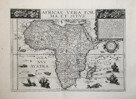
Africae Vera Forma et Sitvs
Mode de Paiement
- PayPal
- Carte bancaire
- Virement bancaire
- Pubblica amministrazione
- Carta del Docente
Détails
- Année
- 1593
- Lieu d'édition
- Anversa
- Format
- 450 X 325
- Graveurs
- DE JODE Cornelis
- Description
- R. L. Betz "The Mapping of Africaâ¦" (2007), map 27; O. I. Norwich, "Norwich's Maps of Africa", map 19
Description
Si tratta della seconda mappa dell'Africa realizzata dalla famiglia De Jode, nella fattispecie realizzata da Cornelis De Jode nel 1593. Suo padre, Gerard, nel 1578 aveva pubblicato l'atlante Speculum Orbis Terrarum, di cui intendeva probabilmente realizzare un'edizione riveduta e ampliata. A causa della sua morte, nel 1591, fu il figlio Cornelis a portarne a compimento il progetto nel 1593 con lo Speculum Orbis Terrae. Realizza così, dieci nuove mappe, tra cui questa carta dell'Africa. Cartograficamente la mappa deriva in parte dalla carta del mondo di Mercator del 1569, ed in parte da quella di Ortelius, pubblicata nel 1570. ' Come tutte le carte della famiglia De Jode, anche questa mappa è molto rara. Infatti, dopo la prematura morte di Cornelis, nel 1600, tutte le lastre passarono a Jan Baptiste Vrients. La vedova di Vrients vendette poi le lastre a Moretus, ma non furono più utilizzate per successive tirature. Incisione in rame, in perfetto stato di conservazione. ' This is the De Jode family's second map of Africa, issued in 1593 by Cornelis de jode. His father, Gerard, in 1578 published the atlas Speculum Orbis Terrarum, and evidently he intended to issue a revisited and expanded edition. Due to his death, Cornelis realized the new edition and in 1593 published the atlas Speculum Orbis Terrae, adding ten new copperplates includind this map of Africa. The large title at the top is flanked by some intricate design work and the oceans are decorated with sailing ships and sea monsters. Cartographically, the map refers to Mercator for the river systems and Ortelius for other points. De Jode had originally intended his atlas to compete with Ortelius' Theatrum Orbis Terrarum. The competition between De Jode and Ortelius had been intense, but the better-connected Ortelius was able to influence events - possibly even ensuring a denial of the necessary Royal Privilege for De Jode until 1577. De Jode's Speculum Orbis Terrarum was issued the next year. The Speculum had to compete against Ortelius' Theatrum Orbis Terrarum, in its eighth year of publication and already in its sixteenth edition, and was unable to make any serious impression on the market-hold enjoyed by Ortelius. De Jode's maps are thus appreciably rarer than those by Ortelius and are often better engravings. A good impression of this finely engraved, rare and sought after map in overall good condition. Cfr. R. L. Betz "The Mapping of Africa…" (2007), map 27; O. I. Norwich, "Norwich's Maps of Africa", map 19