America Septentrionalis.
America Septentrionalis. | Gravures | LOTTER Tobias Conrad


America Septentrionalis.
America Septentrionalis. | Gravures | LOTTER Tobias Conrad
Mode de Paiement
- PayPal
- Carte bancaire
- Virement bancaire
- Pubblica amministrazione
- Carta del Docente
Détails
- Année
- 1762
- Lieu d'édition
- Augsburg
- Format
- 590 X 460
- Graveurs
- LOTTER Tobias Conrad
Description
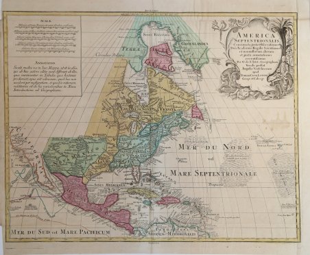
Carta geografica raffigurante la parte centro settentrionale dell’America. Edita ad Ausburg, la carta deriva da quella del De L’Isle, alla quale sono apportate diverse varianti. I Grandi Laghi sono rappresentati secondo il modello di Coronelli, mostra le colonie francesi. Nel Pacifico sono indicate le rotte seguite dai più famosi esporatori. Ma l'aspetto più originale e interessante di questa mappa è la rappresentazione della California. De Lisle, infatti, era stato il primo a rappresentare la regione come una penisola, Lotter lo segue, ma nella parte settentrionale del Golfo della California traccia uno spazio, che lascia quindi aperta la teoria della California come isola. Tobias Conrad Lotter (1717 - 1777) fu un incisore ed editore di mappe tedesco. Lotter sposò Euphrosina Seutter (1709-1784), figlia maggiore dell’editore Matthäus Seutter. Cominciò a lavorare nell'attività cartografica del suocero verso il 1740. Tra il 1740 e il 1744 produsse, sotto la direzione di Seutter, l'Atlas minor, Praecipua orbis terrarum imperia, regna et provincias, Germania potissimum tabelli. Alla morte di Seutter (1757), gli successe suo figlio, Albrecht Karl Seutter (1722-1762). Le lastre delle mappe di Suetter furono successivamente divise tra Lotter e l'editore Johan Mitchell Probst (1727 - 1776). Con il sostegno dei suoi figli, Tobias Conrad Lotter riuscì a costruire il successo economico e la reputazione professionale del suocero. Col tempo, Lotter divenne uno dei più importanti editori di mappe della metà del XVIII secolo che lavoravano nella scuola tedesca. ' Incisione in rame, bellissima coloritura antica. This map is Lotter's version of Guillaume Delisle's map of North America, with several modifications. The Great Lakes are based on the Coronelli model showing the French strong points at Tadousac, Quebec, Fort Sorel, Montreal and Fort Frontenac. In the Pacific are shown the routes of different voyages. The most interesting aspect of the map is the region of California. Delisle was the first cartographer to revert to a peninsula form for California. Lotter follows that here, but engraved the map with a small gap at the head of the Gulf of California, thus leaving the possibility still open for the island theory. The large cartouche features a Native American and a ship's captain. Tobias Conrad Lotter (1717 - 1777) was a German engraver and map publisher. Lotter married Euphrosina Seutter (1709-1784), elder daughter of Matthäus Seutter. He began working at his is father-in-law's map business about 1740. Between 1740 and 1744 he produced, under Seutter's imprint, the Atlas minor, Praecipua orbis terrarum imperia, regna et provincias, Germania potissimum tabelli. Upon Seutter's death, in 1757, the firm's stock was taken over by his son, Albrecht Karl Seutter (1722-1762), who himself died in 1762, just a few years later. The remaining Suetter map plates were subsequently divided between Lotter and the publisher Johan Mitchell Probst (1727 - 1776). With the support of his sons, Matthäus Albrecht (1741-1810), Georg Friedrich (1744-1801) and Gustav Conrad (1746-1776), Tobias Conrad Lotter succeeded in building on the economic success and professional reputation of his father-in-law. In time, Lotter became one of the most prominent mid-18th century map publishers working in the German school. ' Etching on copperplate with fine original handcolour, in good conditions Cfr.
