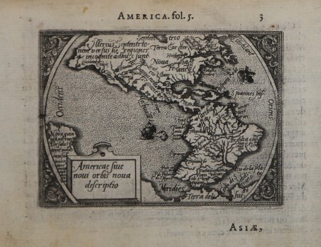
Americae sive novi Orbis nova descriptio
Americae sive novi Orbis nova descriptio | Gravures | GALLE Abraham ORTELIUS - Philip
Americae sive novi Orbis nova descriptio
Americae sive novi Orbis nova descriptio | Gravures | GALLE Abraham ORTELIUS - Philip
Mode de Paiement
- PayPal
- Carte bancaire
- Virement bancaire
- Pubblica amministrazione
- Carta del Docente
Détails
- Année
- 1577
- Lieu d'édition
- Anversa
- Format
- 110 X 80
- Graveurs
- GALLE Abraham ORTELIUS - Philip
- Description
- Koeman 331:12; Phillips 387; G. King, Miniature Antique Maps, pp. 60-61.
Description
Mappa tratta dalla seconda edizione in lingua francese de ' Le Miroir du Monde. Le ' Mirour du Monde ' è l’edizione in lingua francese in prosa dello ' Spieghel der Werelt, il primo atlante tascabile pubblicato nel 1577, in lingua olandese, da Philip Galle, con testo in rima curato da Peeter Heyns, e stampato dalla tipografia Plantin. Lo ' Spieghel der Werelt ' era una versione ridotta del ' Theatrum Orbis Terrarum ' di Ortelius. Le lastre, quasi tutte derivate dal ' Theatrum, furono disegnate e incise da Philip Galle. Due anni dopo, nel 1579, fu data alle stampe l’edizione in lingua francese in prosa, perché Heyns non aveva avuto il tempo necessario per la resa in versi, col titolo ' Le Miroir du Monde. Il successo di questa edizione francese, è provato proprio dalla seconda edizione pubblicata a soli 4 anni di distanza, nel 1583. Dal 1577 al 1598, Galle & Heyns pubblicarono ben 11 edizione, di cui l’ultima – edita nell’anno della morte di Ortelius – conteneva ben 123 mappe. “The concept of this atlas, known more widely as the Epitome, was to produce a reduced format version of the successful folio atlas of Abraham Ortelius first published in 1570. Philippe Galle cut the plates and Pieter Heyns provided the text in verse. It proved to be as popular as its original. This particular map was a reduction of the folio America map in the 1570 edition of the Theatrum. It has the same bulges to the coastlines of south- west South America and the north-west of North America. There were eleven editions using this plate before it was replaced with another. All issues were in oblong format with the exception of the Favolium edition of 1585. This was published in a bigger format to incorporate the larger maps which had been previously folded in; the rest of the other plates are set within the text. In this issue the America map is printed on the reverse of that of the world. The 1598 edition contained a new plate. In Brescia, 1598, another series of reduced versions of the folio maps of Ortelius was published. In 1601 a competitive edition was also produced in Antwerp; the maps were cut by Ambrosius and Ferdinand Arsenius with text provided by Michel Coignet.” (Burden " ' The Mapping of North America", p. 61). Incisione in rame, in ottimo stato di conservazione. ' Bibliografia: Burden "The Mapping of North America", pp. 61-62, n. 48; Koeman 331:12; Phillips 387; G. King, Miniature Antique Maps, pp. 60-61. Miniature map published taken from the second French edition of ' Le Miroir du Monde, published by Galle & Heyns in 1583, printed by Plantin and first publsihed in 1577 under the title ' Spieghel der werelt. Le ' Miror du Monde ' is the French transaltion of the Duch poems ' Spieghel der Werelt, ' the first modern pocket-atlas, published by Philip Galle with text by Peeter Heyns in 1577, based on Abraham Ortelius’ ' Theatrum Orbis Terrarum. The maps were drawn and engraved by Galle. ' Between 1577 & 1598 Galle issued 11 editions, all printed by Christopher Plantin. “The concept of this atlas, known more widely as the Epitome, was to produce a reduced format version of the successful folio atlas of Abraham Ortelius first published in 1570. Philippe Galle cut the plates and Pieter Heyns provided the text in verse. It proved to be as popular as its original. This particular map was a reduction of the folio America map in the 1570 edition of the Theatrum. It has the same bulges to the coastlines of south- west South America and the north-west of North America. There were eleven editions using this plate before it was replaced with another. All issues were in oblong format with the exception of the Favolium edition of 1585. This was published in a bigger format to incorporate the larger maps which had been previously folded in; the rest of the other plates are set within the text. In this issue the America map is printed on the reverse of that of the world. The 1598 edition contained a new plate. In Brescia, 1598, another series of reduced versions of the folio maps of Ortelius was published. In 1601 a competitive edition was also produced in Antwerp; the maps were cut by Ambrosius and Ferdinand Arsenius with text provided by Michel Coignet.” (Burden " ' The Mapping of North America", p. 61). Copperplate, very good condition. ' Bibliografia: Burden "The Mapping of North America", pp. 61-62, n. 48; Koeman 331:12; Phillips 387; G. King, Miniature Antique Maps, pp. 60-61. Cfr.
