ARGONAUTICA
ARGONAUTICA | Gravures | ORTELIUS Abraham
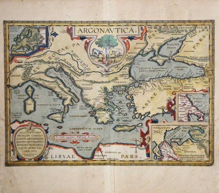
ARGONAUTICA
ARGONAUTICA | Gravures | ORTELIUS Abraham
Mode de Paiement
- PayPal
- Carte bancaire
- Virement bancaire
- Pubblica amministrazione
- Carta del Docente
Détails
- Année
- 1598
- Lieu d'édition
- Anversa
- Format
- 500 X 345
- Graveurs
- ORTELIUS Abraham
- Thème
- Carte Storiche
Description
Splendida carta storico-geografica del viaggio di Giasone e degli Argonauti, pubblicata nel ' Parergon ' di Abraham Ortelius. Esemplare dalla rara edizione italiana del Theatrum Orbis Terrarum stampata ad Anversa da Jean Baptiste Vrients nel 1608 e quindi nel 1612. Titolo in alto ARGONAUTICA. Argonautica descrive il viaggio di Giasone, ed illustra il percorso per tornare nel Mediterraneo attraverso le Colonne d'Ercole. La rappresentazione dei viaggi di Giasone e dei suoi compagni alla ricerca del vello d'oro, sulla loro nave chiamata Argo. Come fecero gli antichi, Ortelius accetta il viaggio come fatto storico e non mitologico; basandosi su una serie di autori classici, conta più di 80 Argonauti per nome e fornisce per ognuno di loro le fonti che ha individuato negli scritti antichi. Tra gli antichi non c'è quasi nessuno che non abbia accennato, per così dire di sfuggita, alla storia degli Argonauti. Ma tra coloro che si sono occupati di questo argomento, come Cleone, Erodoto, Pisandro, Dionigi Milesio, Varrone Attacino ed Epimenide (che, come scrive Laërtes, ha pubblicato ampiamente su questo argomento in 6500 versi), sono rimasti solo tre autori che sono giunti a noi: Caio Valerio Flacco, Orfeo e Apollonio Rodio. In tutti e tre, il viaggio degli Argonauti è descritto in modo abbastanza simile, ma il loro ritorno in patria differisce molto da uno all'altro nei loro racconti. Circa una decade dopo la pubblicazione del “moderno” Theatrum Orbis Terrarum, Ortelius rispose alle “preghiere di amici e studiosi di storia antica, sacra e profana” e compilò una serie di mappe di soggetto biblico e classico, quasi tutte disegnate da lui. Intitolò l’opera “Parergon theatri”, ovvero “aggiunta, appendice, del Theatrum”, ma al tempo stesso anche complementare al Theatrum: il Paregon theatri forniva per il mondo antico lo stesso materiale che Ortelius aveva fornito per il mondo moderno con il Theatrum: carte geografiche. Lo spirito del Parergon è tutto riassunto nel motto historiae oculus geographia riportato sul frontespizio: la geografia è l’occhio della storia. Le mappe del mondo antico avevano lo scopo di “rendere più chiari gli storici antichi e i poeti”. Le mappe del Paregon sono di tre tipologie: antiche regioni; carte letterarie e carte bibliche. Come sottolinea Koeman “il Parergon deve essere considerato come lavoro personale di Ortelius. Per quest'opera, infatti, diversamente dal Theatrum, non copiò le mappe di altri cartografi, ma ne disegnò lui stesso di nuove ed originali. Riprese luoghi, regioni e territori delle civiltà classiche illustrandone e spiegandone la storia, una materia molto vicina al suo cuore. Le mappe e le lastre del Parergon devono essere valutate come le più importanti incisioni che rappresentano il diffuso interesse per la geografia classica nel XVI secolo”. “Le Argonautiche sono un poema greco che narra le vicende degli Argonauti, un gruppo di cinquanta eroi greci, che sotto la guida di Giasone intrapreso un avventuroso viaggio a bordo della nave Argo che li condurrà verso le ostili terre della Colchide (attuale Georgia) alla ricerca del vello d'oro. Pelia, diventato re di lolco dopo aver usurpato il trono al fratello Esone, e fattolo imprigionare insieme ai suoi cari, impose al nipote Giasone (figlio di Esone) la riconquista del vello in cambio del quale avrebbe rilasciato il padre ed suoi cari. Prima tappa del viaggio fu l'isola di Lemno, conosciuta per essere presieduta dalle amazzoni (donne guerriere); da qui riprese il tragitto giungendo alla terra dell'indovino Fineo, il quale era perseguitato dalle Arpie, che in seguito ad una punizione divina, gli impedivano di mangiare. Giasone lo liberò e prosegui alla volta del regno del tiranno Amico, re dei Brebici, che sarà sconfitto da Polluce, uno dei Dioscuri insieme a Castore (Principi di Sparta), in un incontro di pugilato. Giunti finalmente nella Colchide, governata dal re Eete, Giasone scopre che . Splendid historical-geographical map of the journey of Jason and the Argonauts, published in Abraham Ortelius' Parergon. Example from the rare Italian edition of Theatrum Orbis Terrarum printed in Antwerp by Jean Baptiste Vrients in 1608 and again in 1612. The map is a depiction of the travels of Iason and his companions in their quest for the Golden Fleece, on their ship named Argo. Ortelius, basing himself on a host of classical authors, counts more than 80 Argonauts by name, and provides sources for each of them as he established them in ancient writings. Ortelius mentions Valerius Flaccus, Orpheus and Apollonius Rhodius as his prime sources. Ortelius writes: “There is almost none among the ancients who has not as it were in passing touched upon the story of the Argonavts, that is, of Iason, or of the Golden Fleece. But among those that have purposed to handle that matter, such as Cleon, Herodotus, Pisander, Dionysius Milesius, Varro Attacinus, and Epimenides, (who, as Laërtes writes, has published extensively about this in 6500 verses), there are only three [authors] remaining now that have come into our hands, namely Caius Valerius Flaccus, Orpheus and Apollonius Rhodius. In all three [of these authors], the journey outwards of those Argonauts that is, of Iason and his companions who sailed with him on the ship named Argo) is described reasonably similarly, but their return homewards differs very much from one to another in their accounts. This voyage therefore we have on this map of ours, composed on the basis of those three authors mentioned, which will easily and plainly become clear to whoever examines them and the stories they published. Next to those places they mention, we have added certain others from other authors, never visited by them, but still pertaining to their purpose”. The Parergon is the first historical atlas ever published. It was initially conceived by Ortelius as an appendix to his Theatrum Orbis Terrarum but given the considerable success of these historical maps it later became an independent work and remained the main source of all similar works throughout the seventeenth century. Koeman wrote: “This atlas of ancient geography must be regarded as a personal work of Ortelius. For this work he did not, as in the Theatrum, copy other people's maps but drew the originals himself. He took many places and regions from the lands of classical civilization to illustrate and clarify their history, a subject very close to his heart. The maps and plates of the Parergon have to be evaluated as the most outstanding engravings depicting the wide-spread interest in classical geography in the 16th century." The Theatrum Orbis Terrarum, which is considered the first true modern "Atlas". The work was published in 7 languages and 36 editions, for which - in 1570 - Ortelius obtained the privilege, a kind of copyright that prevented other cartographers from publishing his works. The Theatrum represented the most advanced work of cartographic description. Ortelius collected in it the geographical and cartographic knowledge of his time, proposing in 147 spectacular engraved plates the most faithful image of the world then known and, in some extraordinary "historical maps", regions and routes taken from literature, mythology, tradition. Example with magnificent contemporary coloring, paper slightly browned, otherwise in excellent condition. Bibliografia Cfr. L. Bagrow, A. Ortelli Catalogus Cartographorum; cfr. C. Koeman, Atlantes Neerlandici; Peter H. Meurer, Fontes Cartographici Orteliani, n. 38p; M. Van den Broecke, Ortelius Atlas Maps, n. 266; Van der Krogt, Koeman’s Atantes Neerlandici: 0310H:31. ' Cfr.
