Asia recens summa cura delineata
Asia recens summa cura delineata | Gravures | HONDIUS Jr. Jodocus
Asia recens summa cura delineata
Asia recens summa cura delineata | Gravures | HONDIUS Jr. Jodocus
Mode de Paiement
- PayPal
- Carte bancaire
- Virement bancaire
- Pubblica amministrazione
- Carta del Docente
Détails
- Année
- 1623
- Lieu d'édition
- Amsterdam
- Format
- 555 X 410
- Graveurs
- HONDIUS Jr. Jodocus
Description
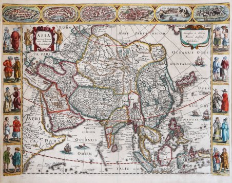
Carta à figure dell’Asia di Jodocus Hondius jr, incisa da Pieter van den Keere. Nel 1619 Jodocus Hondius jr. incide una prima versione della carta dell’Asia con le figure. Dopo solo 4 anni decide di realizzare le carte dei continenti, commissionando il lavoro a Pieter van den Keere; questa carta dell’Asia che proponiamo appartiene a questo set, datato 1623. Della lastra esistono cinque stati; il nostro esemplare è del quinto stato finale, con imprint di Johannes Janssonius, con le figure delle città in basso rimosse, la data nel cartiglio cancellata e senza il testo al verso. Scrive Gunther Schileder: “Only four years later the publication of his folio-size map of Asia, Jodocus Hondius Jr. issued one which forms part of a set of maps of the four continents of which Africa and Asia are dated 1623. It must be assumed that Pieter van den Keere either engraved the set or commissioned it to be engraved. The title of the Asia map appears in the upper left in a cartouche which is a mirror image of that on Jodocus Hondius's 1619 map. The imprint is in a cartouche in the upper right. The map is surrounded on both sides by costumed Asian figures, and along the upper and lower edges run decorative borders with six Asian towns in oval frames. Top border: FAMAGUSTA; RODUS; DAMASCO; IERUSALEM; ADEN; and ORMUS. Bottom border: GOA; CALECUTH; CANDY; BANTAM; GAMMALAMME; and MACAO. Left border: SYRI; ARABES; ARMENIUS PERSE; BALAGUATÆ; and INSULANI SUMATRÆ. Right border: IAVANI; INC: MOLUCC: et BANDÆ; CHINENSES; MOSCOVITE; and TARTARI. The town views are identical to Hondius's 1619 map of Asia, and the depictions of the costumed figures are mirror images of those found on this map” (cfr. Monumenta Cartographica Neerlandica, p. 150). Acquaforte, finemente colorata a mano, con margini, in perfetto stato di conservazione. Molto rara. Bibliografia G. Schilder, ' Monumenta Cartographica Neerlandica, vol. VI, pp. 150/55, 23.5. Carte à figure of Asia by Jodocus Hondius Jr. engraved by Pieter van den Keere. In 1619 Jodocus Hondius jr. engraved the first version of the map of Asia with figures. After four years he decided to realize the maps of the continents, commissioning the job to Pieter van den Keere; this representation of Asia belongs to this set, dated 1623. Five states exist of the plate; our example is of the final fifth state, with imprint by Johannes Janssonius, with the figures of the cities below removed, the date in the cartouche erased, and without the text on the verso. “Only four years later the publication of his folio-size map of Asia, Jodocus Hondius Jr. issued one which forms part of a set of maps of the four continents of which Africa and Asia are dated 1623. It must be assumed that Pieter van den Keere either engraved the set or commissioned it to be engraved. The title of the Asia map appears in the upper left in a cartouche which is a mirror image of that on Jodocus Hondius's 1619 map. The imprint is in a cartouche in the upper right. The map is surrounded on both sides by costumed Asian figures, and along the upper and lower edges run decorative borders with six Asian towns in oval frames. Top border: FAMAGUSTA; RODUS; DAMASCO; IERUSALEM; ADEN; and ORMUS. Bottom border: GOA; CALECUTH; CANDY; BANTAM; GAMMALAMME; and MACAO. Left border: SYRI; ARABES; ARMENIUS PERSE; BALAGUATÆ; and INSULANI SUMATRÆ. Right border: IAVANI; INC: MOLUCC: et BANDÆ; CHINENSES; MOSCOVITE; and TARTARI. The town views are identical to Hondius's 1619 map of Asia, and the depictions of the costumed figures are mirror images of those found on this map” (cfr. Monumenta Cartographica Neerlandica, p. 150). Copper engraving with fine later hand colour, with margins, in excellent condition. Very rare. Bibliografia G. Schilder, ' Monumenta Cartographica Neerlandica, vol. VI, pp. 150/55, 23.5. Cfr.
