Austria Descrip. per Wolfgangum Lazium

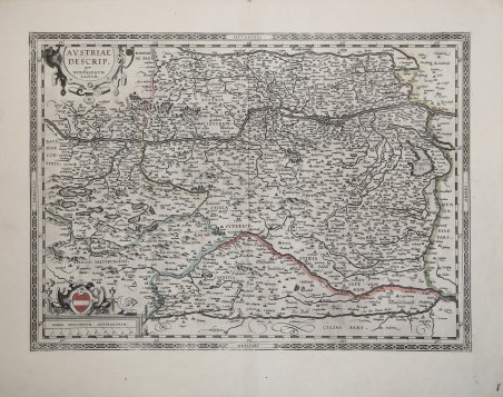
Austria Descrip. per Wolfgangum Lazium
Mode de Paiement
- PayPal
- Carte bancaire
- Virement bancaire
- Pubblica amministrazione
- Carta del Docente
Détails
- Année
- 1592
- Lieu d'édition
- Anversa
- Format
- 485 X 350
- Graveurs
- ORTELIUS Abraham
Description
Questa bella mappa dell'Austria presenta un'immagine distorta del corso dei fiumi Drava, Mur, Gurk e Lavant con numerosi laghi spuri. I fiumi del nord sono rappresentati molto più accuratamente. Ortelius ha basato questa mappa sulla cartografia di Wolfgang Lazius. Questa è la seconda tavola, aggiornata con due cartigli, e stampata per la prima volta nel 1592. Carta tratta dal ' Theatrum Orbis Terrarum ' e che è considerato il primo vero “atlante” moderno. L’opera fu pubblicata in 7 lingue e 36 edizioni, per il quale – nel 1570 - Ortelius ottenne il ' privilegio, ovvero una sorta di diritto d'autore che impediva ad altri cartografi di pubblicare i propri lavori. Il ' Theatrum ' rappresentava il lavoro più avanzato del lavoro della descrizione cartografica. L’Ortelius vi raccolse il sapere geografico e cartografico del suo tempo, proponendo in 147 spettacolari tavole incise l’immagine più fedele del mondo allora conosciuto e, in alcune straordinarie “carte storiche”, regioni e itinerari tratti dalla letteratura, dalla mitologia, dalla tradizione. Ortelius fu anche il primo a citare le fonti, menzionando i nomi dei cartografi nel “catalogus auctorum”. Dal 1598 al 1612 le edizioni postume del ' Theatrum ' furono realizzate dal suo collaboratore Johannes Baptiste Vrients. Incisione in rame, in ottimo stato di conservazione. This handsome map of Austria presents a distorted picture of the course of the rivers Drau, Mur, Gurk and Lavant with numerous spurious lakes. The rivers in the north are much more accurately represented. Ortelius based this map on the cartography of Wolfgang Lazius. ' This is the second plate, updated with two strapwork cartouches. ' Map taken from the Theatrum Orbis Terrarum, which is considered the first true modern "Atlas". The work was published in 7 languages and 36 editions, for which - in 1570 - Ortelius obtained the privilege, a kind of copyright that prevented other cartographers from publishing his works. The Theatrum represented the most advanced work of cartographic description. Ortelius collected in it the geographical and cartographic knowledge of his time, proposing in 147 spectacular engraved plates the most faithful image of the world then known and, in some extraordinary "historical maps", regions and routes taken from literature, mythology, tradition. Ortelius was also the first to cite sources, mentioning the names of cartographers in the "catalogus auctorum". From 1598 to 1612 the posthumous editions of the Theatrum were made by his collaborator Johannes Baptiste Vrients. Copper engraving, in good condition. Cfr.