Britannicarum Insularum Typus
Britannicarum Insularum Typus | Gravures | ORTELIUS Abraham

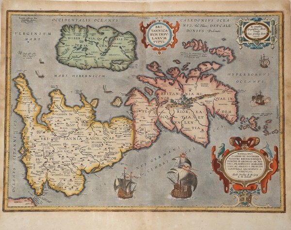
Britannicarum Insularum Typus
Britannicarum Insularum Typus | Gravures | ORTELIUS Abraham
Mode de Paiement
- PayPal
- Carte bancaire
- Virement bancaire
- Pubblica amministrazione
- Carta del Docente
Détails
- Année
- 1595
- Lieu d'édition
- Anversa
- Format
- 510 X 370
- Graveurs
- ORTELIUS Abraham
- Thème
- Carte Storiche
- Description
- Van den Broecke #192; Shirley, R.W. (BI to 1650) 186, pl.42.
Description
Decorativa carta geografica delle Isole Britanniche, riferita al tempo degli antichi Romani.La carta, per la prima volta pubblicata da Ortelius nel suo Parergon del 1595, è basta su informazioni geografiche fornite dalla carta murale delle Isole Britanniche di Mercator (1564) e sugli aggiornamenti forniti da Saxton (1579). Le notizie storiche sono invece derivanti dalle fonti classiche quali Plinio, Tacito, Appiano e Strabone. Tratta dal ' Parergon, il primo atlante storico mai pubblicato. Fu inizialmente concepito da Ortelius come appendice del suo ' Theatrum Orbis Terrarum ' ma visto il notevole successo di queste carte storiche divenne in seguito un lavoro indipendente e rimase la fonte principale di tutti i lavori simili per tutto il XVII secolo. Come sottolinea Koeman “il ' Parergon ' deve essere considerato come lavoro personale di Ortelius. Per quest'opera, infatti, diversamente dal ' Theatrum, non copiò le mappe di altri cartografi, ma ne disegnò lui stesso di nuove ed originali…prese luoghi, regioni e territori delle civiltà classiche illustrandone e spiegandone la storia, una materia molto vicina al suo cuore. Le mappe e le lastre del ' Parergon ' devono essere valutate come le più importanti incisioni che rappresentano il diffuso interesse per la geografia classica nel XVI secolo”. Il ' Theatrum Orbis Terrarum ' e che è considerato il primo vero “atlante” moderno. L’opera fu pubblicata in 7 lingue e 36 edizioni, per il quale – nel 1570 - Ortelius ottenne il ' privilegio, ovvero una sorta di diritto d'autore che impediva ad altri cartografi di pubblicare i propri lavori. Il ' Theatrum ' rappresentava il lavoro più avanzato del lavoro della descrizione cartografica. L’Ortelius vi raccolse il sapere geografico e cartografico del suo tempo, proponendo in 147 spettacolari tavole incise l’immagine più fedele del mondo allora conosciuto e, in alcune straordinarie “carte storiche”, regioni e itinerari tratti dalla letteratura, dalla mitologia, dalla tradizione. Esemplare tratto dall'edizione latina del 1619. Incisione in rame, finemente colorata a mano, in ottimo stato di conservazione. Bibliografia Cfr. L. Bagrow, ' A. Ortelli Catalogus Cartographorum; cfr. C. Koeman, ' Atlantes Neerlandici; ' Peter H. Meurer, ' Fontes Cartographici Orteliani ' 34p; M. Van den Broecke, ' Ortelius Atlas Maps, n. 192; Van der Krogt, ' Koeman’s Atantes Neerlandici: 5000H:31B; R.W. Shirley (1991) "Early Printed Maps of the British Isles" 1477-1650, Antique Atlas Pub. ' East Grinstead, maps 186 (plate 71), 259a, 365. Decorative and rare map of the British Isles in Roman times. The map was first published in the 1595 edition of Ortelius' atlas. The map was made based upon modern information from Mercator's 1564 map of the British Isles, improved by a new outline from Saxton's 1579 map (Meurer p. 197, Karrow 56/16, p. 387-388)nd ancient knowledge from Diodorus, Siculus, Plinius, Appianus, Tacitus, Cæsar and Strabo. The map is filled with ancient place names, Hadrian's Wall, and Wall of Pius (mislabeled Severi Imp. Murus).Richly embellished with three large strapwork cartouches and several sailing vessels. Map taken from the ' Parergon, the first historical atlas ever published. It was initially conceived by Ortelius as an appendix to his ' Theatrum Orbis Terrarum, but given the considerable success of these historical maps it later became an independent work and remained the main source of all similar works throughout the seventeenth century. Koeman wrote: "This atlas of ancient geography must be regarded as a personal work of Ortelius. For this work he did not, as in the ' Theatrum, copy other people's maps but drew the originals himself. He took many places and regions from the lands of classical civilization to illustrate and clarify their history, a subject very close to his heart. The maps and plates of the ' Parergon ' have to be evaluated as the most outstanding engravings depicting the wide-spread interest in classical geography in the 16th century." The ' Theatrum Orbis Terrarum, which is considered the first true modern "Atlas". The work was published in 7 languages and 36 editions, for which - in 1570 - Ortelius obtained the privilege, a kind of copyright that prevented other cartographers from publishing his works. The ' Theatrum ' represented the most advanced work of cartographic description. Ortelius collected in it the geographical and cartographic knowledge of his time, proposing in 147 spectacular engraved plates the most faithful image of the world then known and, in some extraordinary "historical maps", regions and routes taken from literature, mythology, tradition. Latin editon of 1619. Copperplate with fine hand colouring, very good condition. Bibliografia Cfr. L. Bagrow, ' A. Ortelli Catalogus Cartographorum; cfr. C. Koeman, ' Atlantes Neerlandici; ' Peter H. Meurer, ' Fontes Cartographici Orteliani ' 34p; M. Van den Broecke, ' Ortelius Atlas Maps, n. 192; Van der Krogt, ' Koeman’s Atantes Neerlandici: 5000H:31B; R.W. Shirley (1991) "Early Printed Maps of the British Isles" 1477-1650, Antique Atlas Pub. ' East Grinstead, maps 186 (plate 71), 259a, 365. Cfr. Van den Broecke #192; Shirley, R.W. (BI to 1650) 186, pl.42.
