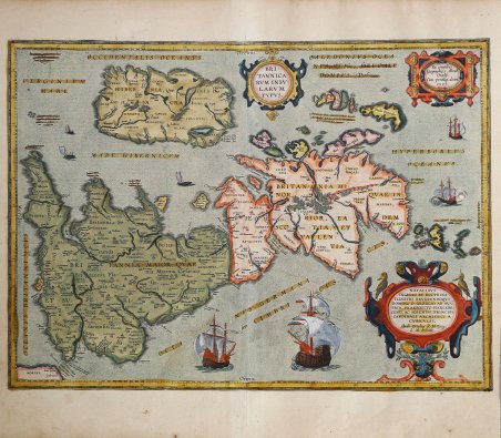
Splendida carta storico-geografica dell'antico arcipelago britannico al tempo dei Romani, pubblicata nel ' Parergon ' di Abraham Ortelius. Esemplare dalla rara edizione italiana del Theatrum Orbis Terrarum stampata ad Anversa da Jean Baptiste Vrients nel 1608 e quindi nel 1612. Titolo: BRI:|TANNICA:|RVM INSV:|LARVM | TYPVS. Cartiglio in alto a destra: "Ex conatibus | Geographicis Abrah. | Ortelij. | Cum privileg. decen. | 1595". Cartiglio in basso a destra: NATALIBVS | INGENIO ET DOCTRINA | ILLVSTRI REVERENDOQVE | DOMINO D. GEORGIO AB AVS:|TRIA, PRAEPOSITO HARLEBE:|CENSI, AC SERENISS. PRINCIPI | CARDINALI ARCHIDVCI A | CVBICVLIS, | "Abrah. Ortelius R.M. Geog. | L.M. dedicab". [Abramo Ortelio, che si compiace di essere il geografo di Sua Maestà il Re, dedica questa carta, destinata all'istruzione e all'educazione del popolo, a Giorgio d'Austria, servitore del serenissimo signore, cardinale e arciduca di Harlebeck]. Al centro a destra: ORCADES "Insulæ, triginta plus | minus numero". A sinistra in basso: "Hoc loco Cæsarem appuliße | prima navigatione putatur". Realizzata da Ortelio sulla base di informazioni moderne tratte dalla carta delle isole britanniche di Mercatore del 1564, migliorate da un nuovo schema della carta di Saxton del 1579 (Meurer p. 197, Karrow 56/16, p. 387-388) e di conoscenze antiche tratte da Diodoro Siculo, Plinio, Appiano, Tacito, Cesare, Strabone e numerosi altri scrittori romani. Circa una decade dopo la pubblicazione del “moderno” Theatrum Orbis Terrarum, Ortelius rispose alle “preghiere di amici e studiosi di storia antica, sacra e profana” e compilò una serie di mappe di soggetto biblico e classico, quasi tutte disegnate da lui. Intitolò l’opera “Parergon theatri”, ovvero “aggiunta, appendice, del Theatrum”, ma al tempo stesso anche complementare al Theatrum: il Paregon theatri forniva per il mondo antico lo stesso materiale che Ortelius aveva fornito per il mondo moderno con il Theatrum: carte geografiche. Lo spirito del Parergon è tutto riassunto nel motto historiae oculus geographia riportato sul frontespizio: la geografia è l’occhio della storia. Le mappe del mondo antico avevano lo scopo di “rendere più chiari gli storici antichi e i poeti”. Le mappe del Paregon sono di tre tipologie: antiche regioni; carte letterarie e carte bibliche. Come sottolinea Koeman “il Parergon deve essere considerato come lavoro personale di Ortelius. Per quest'opera, infatti, diversamente dal Theatrum, non copiò le mappe di altri cartografi, ma ne disegnò lui stesso di nuove ed originali. Riprese luoghi, regioni e territori delle civiltà classiche illustrandone e spiegandone la storia, una materia molto vicina al suo cuore. Le mappe e le lastre del Parergon devono essere valutate come le più importanti incisioni che rappresentano il diffuso interesse per la geografia classica nel XVI secolo”. “Plinio pone molte isole chiamate Britannice nel mare Atlantico, overo Oceano; ma due maggiori cosi in particolarita si chiamano da lui, & da altri; & sono Albione, Inghilterra, & Hibernia Irlanda. Delle quali l'Inghilterra, per la sua grandezza, & come di loro la primiera, si nomina propriamente Britannia" (p. ix). La presente carta farà la sua comparsa nel 1595 andando a sostituire quella in due fogli dal titolo Britannicarum Insularum vetus descriptio, incisa con ogni probabilità da Jan Wierix (Van der Broecke: 242) in cui il disegno cartografico aveva uno sviluppo verticale. In questo caso, la scelta di porre il lato settentrionale lungo il margine destro, permette la riduzione ad un unico foglio in cui la cartografia del Regno Unito si sviluppa lungo la diagonale. La carta, come quella in due fogli, venne realizzata da Ortelius sulla base di moderne informazioni tratte dalla carta di Mercatore delle Isole Britanniche del 1564, migliorata dal nuovo contorno proposto dalla carta di Saxton del 1579 ed informazioni storiche tratte da Diodoro Siculo, Plinio. Splendid historical map of the ancient British Isles, published in Abraham Ortelius' Parergon. Example from the rare Italian edition of Theatrum Orbis Terrarum printed in Antwerp by Jean Baptiste Vrients in 1608 and then in 1612. Title: BRI:|TANNICA:|RVM INSV:|LARVM | TYPVS. Cartouche upper right: "Ex conatibus | Geographicis Abrah. | Ortelij. | Cum privileg. decen. | 1595". Cartouche bottom right: NATALIBVS | INGENIO ET DOCTRINA | ILLVSTRI REVERENDOQVE | DOMINO D. GEORGIO AB AVS:|TRIA, PRAEPOSITO HARLEBE:|CENSI, AC SERENISS. PRINCIPI | CARDINALI ARCHIDVCI A | CVBICVLIS, | "Abrah. Ortelius R.M. Geog. | L.M. dedicab". [Abraham Ortelius, pleased to be the geographer of his majesty the king dedicates this map, intended as instruction and learning for the people, to George of Austria, servant to the most serene lord, cardinal and archduke of Harlebeck]. Middle right: ORCADES "Insulæ, triginta plus | minus numero". [The Orkney islands, about thirty in number]. Left bottom: "Hoc loco Cæsarem appuliße | prima navigatione putatur". [In this place it is thought that Cæsar landed on his first sea journey]. Made by Ortelius on the basis of modern information from Mercator's 1564 map of the British Isles, improved by a new outline from Saxton's 1579 map (Meurer p. 197, Karrow 56/16, p. 387-388) and ancient knowledge from Diodorus Siculus, Plinius, Appianus, Tacitus, Cæsar, Strabo and numerous other Roman writers. Oriented to the west, the British Isles are shown as if on their side. The political divisions show England, Scotland, and Ireland. In the surrounding waters are the Scilly Isles, the Hebrides, and the Orkney Islands. In the upper left corner, Ortelius lists four islands whose locations are ' incognite. Just a sliver of the European continent is shown, labeled as ' Morini, which refers to a Belgic coastal people who lived in the Pas de Calais region. The outline of the British Isles is modern, based on Mercator’s 1564 map of the British Isles and Saxton’s 1579 map. ' The Parergon is the first historical atlas ever published. It was initially conceived by Ortelius as an appendix to his Theatrum Orbis Terrarum but given the considerable success of these historical maps it later became an independent work and remained the main source of all similar works throughout the seventeenth century. Koeman wrote: “This atlas of ancient geography must be regarded as a personal work of Ortelius. For this work he did not, as in the Theatrum, copy other people's maps but drew the originals himself. He took many places and regions from the lands of classical civilization to illustrate and clarify their history, a subject very close to his heart. The maps and plates of the Parergon have to be evaluated as the most outstanding engravings depicting the wide-spread interest in classical geography in the 16th century." The Theatrum Orbis Terrarum, which is considered the first true modern "Atlas". The work was published in 7 languages and 36 editions, for which - in 1570 - Ortelius obtained the privilege, a kind of copyright that prevented other cartographers from publishing his works. The Theatrum represented the most advanced work of cartographic description. Ortelius collected in it the geographical and cartographic knowledge of his time, proposing in 147 spectacular engraved plates the most faithful image of the world then known and, in some extraordinary "historical maps", regions and routes taken from literature, mythology, tradition. Example with magnificent contemporary coloring, paper slightly browned, otherwise in excellent condition. Bibliografia Cfr. L. Bagrow, A. Ortelli Catalogus Cartographorum; cfr. C. Koeman, Atlantes Neerlandici; Peter H. Meurer, Fontes Cartographici Orteliani 34p; M. Van den Broecke, Ortelius Atlas Maps, n. 192; Van der Krogt, Koeman’s Atantes Neerlandici: 5000H:31B; R.W. Shirley (1991) "Early Printed Maps of the British Isles" 1477-1650, Antique Atlas Pub. East Grinstead, maps 186. Cfr.

 Découvrez comment utiliser
 Découvrez comment utiliser