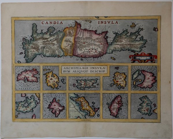
Candia Insula & Archipelagi Insularum Aliquot Descrip.
Candia Insula & Archipelagi Insularum Aliquot Descrip. | Gravures | ORTELIUS Abraham

Candia Insula & Archipelagi Insularum Aliquot Descrip.
Candia Insula & Archipelagi Insularum Aliquot Descrip. | Gravures | ORTELIUS Abraham
Mode de Paiement
- PayPal
- Carte bancaire
- Virement bancaire
- Pubblica amministrazione
- Carta del Docente
Détails
- Année
- 1584
- Lieu d'édition
- Anversa
- Format
- 505 X 365
- Graveurs
- ORTELIUS Abraham
- Description
- Marcel van den Broecke. Ortelius Atlas Maps, no.147.
Description
Carta geografica dell'Isola di Creta e di Lesbos, Kithyra, Karpatos, Naxos, Santorini, Milos, Lemnos, Eubea, Rodhes and Chios. Carta tratta dal ' Theatrum Orbis Terrarum ' e che è considerato il primo vero “atlante” moderno. L’opera fu pubblicata in 7 lingue e 36 edizioni, per il quale – nel 1570 - Ortelius ottenne il ' privilegio, ovvero una sorta di diritto d'autore che impediva ad altri cartografi di pubblicare i propri lavori. Il ' Theatrum ' rappresentava il lavoro più avanzato del lavoro della descrizione cartografica. L’Ortelius vi raccolse il sapere geografico e cartografico del suo tempo, proponendo in 147 spettacolari tavole incise l’immagine più fedele del mondo allora conosciuto e, in alcune straordinarie “carte storiche”, regioni e itinerari tratti dalla letteratura, dalla mitologia, dalla tradizione. Ortelius fu anche il primo a citare le fonti, menzionando i nomi dei cartografi nel “catalogus auctorum”. Dal 1598 al 1612 le edizioni postume del ' Theatrum ' furono realizzate dal suo collaboratore Johannes Baptiste Vrients. Incisione in rame, finemente colorata a mano, in ottimo stato di conservazione. A rare and beautiful 1584 Abraham Ortelius map of Crete and ten other Greek islands. On top a large map of Crete and below 10 small maps of Metellino-Cerigo-Scarpanto-Nicsia-Santorini-Milo-Stalimene-Negroponte-Rodus- Scio. Map taken from the ' Theatrum Orbis Terrarum, which is considered the first true modern "Atlas". The work was published in 7 languages and 36 editions, for which - in 1570 - Ortelius obtained the privilege, a kind of copyright that prevented other cartographers from publishing his works. The ' Theatrum ' represented the most advanced work of cartographic description. Ortelius collected in it the geographical and cartographic knowledge of his time, proposing in 147 spectacular engraved plates the most faithful image of the world then known and, in some extraordinary "historical maps", regions and routes taken from literature, mythology, tradition. Ortelius was also the first to cite sources, mentioning the names of cartographers in the "catalogus auctorum". From 1598 to 1612 the posthumous editions of the ' Theatrum ' were made by his collaborator Johannes Baptiste Vrients. Copperplate, fine later hand colouring, very good condition. Cfr. Marcel van den Broecke. Ortelius Atlas Maps, no.147.
