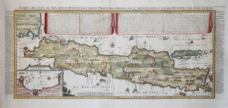
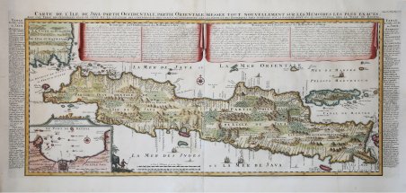
Carte de l'Ile de Java: partie Occidentale, partie Orientale, Dressée tout nouvellement sur les Mémoirs les plus exacts; Avec une Table des principales villes de cette Ile, La situation des comptoirs & autres places qu'y possedent les Hollandois, et des Remarques très curiueuses sur la maniere dont ils se sont établis dans la Ville de Batavia. Una mappa molto importante della regione, preparata da Henri Chatelain per la pubblicazione nel suo monumentale Atlas Historique in sette volumi, 1718. La mappa di Chatelain di Java rappresenta di gran lunga il più sofisticato studio dell'isola mai pubblicato prima. La carta suggerisce che Chatelain in qualche modo ha ottenuto i suoi dati da una fonte al di fuori del V.O.C (la Compagnia olandese delle Indie Orientali). È molto probabile che Chatelain abbia estratto molte delle sue informazioni cartografiche su Java da Hadrien Reland, uno studioso e filologo olandese che ha composto una serie di opere sull'arcipelago indonesiano all'inizio del XVIII secolo. Copre l'isola per intero così come le parti adiacenti di Sumatra e Bali. Offre belle incisioni e dettagli straordinari in tutto, annotando piantagioni di riso, catene montuose, pascoli, foreste e, in molti luoghi, elefanti e gazzelle. La costa meridionale, precedentemente sconosciuta, è mappata correttamente e in modo molto dettagliato. Mostra anche alcune scogliere al largo e altri pericoli. L'isola vulcanica di Krakatau, qui identificata come Cracatao appare nello stretto di Sunda tra Java e Sumatra. Nel quadrante in basso a sinistra, un riquadro mostra in dettaglio la città e il porto di Batavia (odierna Jackarta), allora il centro dell'attività della Compagnia Olandese delle Indie Orientali nella regione. Henri Abraham Chatelain (1684 - 1743) era un pastore ugonotto di origini parigine. È meglio conosciuto come cartografo olandese e più specificamente per il suo contributo cartografico nell’Atlas Historique in sette volumi, pubblicato ad Amsterdam tra il 1705 e il 1720. Innovativo per il suo tempo, l'Atlas Historique combinava incisioni e opere d'arte con studi di geografia, storia, etnologia, araldica e cosmografia. Alcuni studiosi suggeriscono che l'Atlas Historique non fu compilato esclusivamente da Henri Chatelain, come si crede comunemente, ma piuttosto fu un'impresa familiare che coinvolse Henri, suo padre Zacharie e suo fratello, sempre Zacharie. Acquaforte, impressa su due fogli di carta vergata coeva, finemente colorata a mano, condizioni perfette. Carte de l'Ile de Java: partie Occidentale, partie Orientale, Dressée tout nouvellement sur les Mémoirs les plus exacts; Avec une Table des principales villes de cette Ile, La situation des comptoirs & autres places qu'y possedent les Hollandois, et des Remarques très curiueuses sur la maniere dont ils se sont établis dans la Ville de Batavia. ' A highly important map of the region and a must for an serious collection focusing on the East Indies. Prepared by Henri Chatelain for publication in his monumental seven volume Atlas Historique, 1718. In its day Chatelain's map of Java was by far the most sophisticated study of the island yet published. The publication of Chatelain's map of Java suggests that Chatelain somehow obtained his data from a source outside of the V.O.C. It is highly likely that Chatelain extracted much of his cartographic information on Java from Hadrien Reland, a Dutch scholar and philologist who composed a number of works on the Indonesian Archipelago in the early 18th century. Covers the island in full as well as adjacent parts of Sumatra and Bali. Offers beautiful engraving and extraordinary detail throughout, noting rice plantations, mountain ranges, grazing lands, forests, and in many places, elephants and gazelle. The previously unknown southern shore is mapped both correctly and in considerable detail. Also shows some offshore reefs and other dangers. The volcanic island of Krakatau, here identified as Cracatao, which nearly 150 years later would erupt with devastating consequences, appears in the Strait of Sunda between Java and Sumatra. In the lower left quadrant an inset details the city and port of Batavia, then the center of Dutch East Indian Company's activity in the region. Henri Abraham Chatelain (1684 - 1743) was a Huguenot pastor of Parisian origins. He is best known as a Dutch cartographer and more specifically for his cartographic contribution in the seminal seven volume Atlas Historique, published in Amsterdam between 1705 and 1720. Innovative for its time, the Atlas Historique combined fine engraving and artwork with scholarly studies of geography, history, ethnology, heraldry, and cosmography. Some scholarship suggests that the Atlas Historique was not exclusively compiled by Henri Chatelain, as is commonly believed, but rather was a family enterprise involving Henri, his father Zacharie and his brother, also Zacharie. Copperplate with fine later hand colour, perfect condition. Cfr. Koeman, CHA 6, no. 9.

 Découvrez comment utiliser
 Découvrez comment utiliser