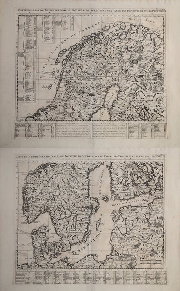
Carte de la parte Septentrionale du royaume de avec une table des Provinces et Villes principales
Carte de la parte Septentrionale du royaume de avec une table des Provinces et Villes principales | Gravures | CHATELAIN Henri Abraham

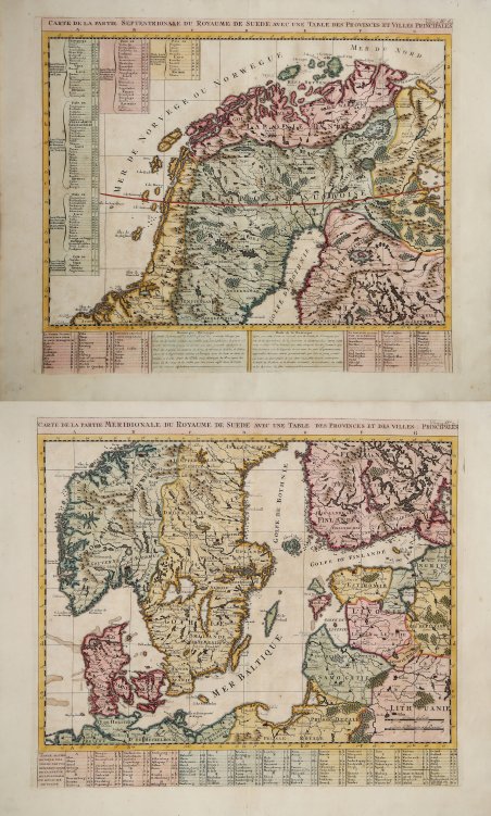
Carte de la parte Septentrionale du royaume de avec une table des Provinces et Villes principales
Carte de la parte Septentrionale du royaume de avec une table des Provinces et Villes principales | Gravures | CHATELAIN Henri Abraham
Mode de Paiement
- PayPal
- Carte bancaire
- Virement bancaire
- Pubblica amministrazione
- Carta del Docente
Détails
- Année
- 1708
- Lieu d'édition
- Amsterdam
- Format
- 460 X 400
- Graveurs
- CHATELAIN Henri Abraham
- Langues
- Italien
Description
Coppia di carte geografiche tratta da "Atlas Historique", pubblicato ad Amsterdam tra il 1705 e il 1720. La mappa ritrae tutta la Svezia settentrionale e parte della Finlandia settentrionale, comprendendo la parte più a nord della Norvegia e la parte settentrionale del confine russo. Grande attenzione è stata prestata alle caratteristiche geografiche della zona così come alle numerose vie navigabili e alle catene montuose sparse sul territorio. L'accurata tabella in basso identifica i vari ducati e fornisce un elenco dei principali laghi e fiumi. Henri Abraham Chatelain (1684 - 1743) era un pastore ugonotto di origini parigine. È meglio conosciuto come cartografo olandese e più specificamente per il suo contributo cartografico nell’Atlas Historique ' in sette volumi, pubblicato ad Amsterdam tra il 1705 e il 1720. Innovativo per il suo tempo, l'Atlas Historique ' combinava incisioni e opere d'arte con studi di geografia, storia, etnologia, araldica e cosmografia. Alcuni studiosi suggeriscono che l'Atlas Historique ' non fu compilato esclusivamente da Henri Chatelain, come si crede comunemente, ma piuttosto fu un'impresa familiare che coinvolse Henri, suo padre Zacharie e suo fratello, sempre Zacharie. Acquaforte, finemente colorata a mano, in ottimo stato di conservazione. The map covers all of northern Sweden and part of northern Finland. It includes most of northern Norway and the northern section of the Russian border. Great attention has been paid to the geographical features of the area as well as the many waterways and mountains scattered across the terrain. The extensive key table identifies the various duchies and provides a list of the major lakes and rivers. By combining a wealth of historical and geographical information with delicate engraving and an uncomplicated composition, this elegant map is a superb example from the golden age of French mapmaking. Taken from "Atlas Historique". Henri Abraham Chatelain (1684 - 1743) was a Huguenot pastor of Parisian origins. He is best known as a Dutch cartographer and more specifically for his cartographic contribution in the seminal seven volume ' Atlas Historique, published in Amsterdam between 1705 and 1720. Innovative for its time, the ' Atlas Historique ' combined fine engraving and artwork with scholarly studies of geography, history, ethnology, heraldry, and cosmography. Some scholarship suggests that the ' Atlas Historique ' was not exclusively compiled by Henri Chatelain, as is commonly believed, but rather was a family enterprise involving Henri, his father Zacharie and his brother, also Zacharie. Copperplate, printed on two sheets, fine later hand colour, good condition. Cfr.
