Carte des Iles Maldive Levée en 1835 par M. M. R. Moresby et P. T. Powell…
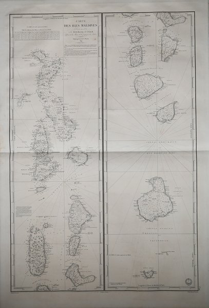
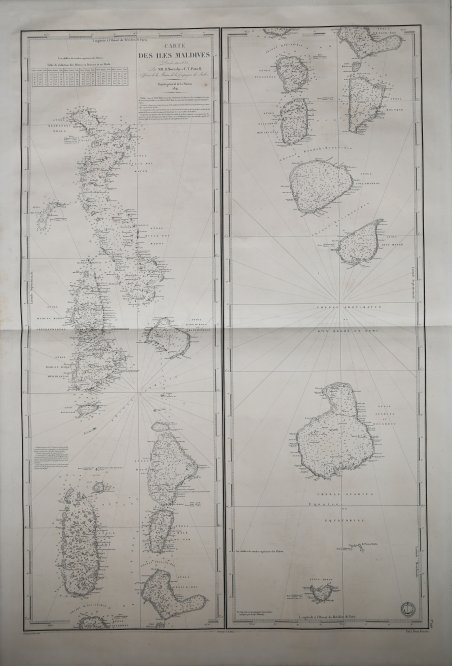
Carte des Iles Maldive Levée en 1835 par M. M. R. Moresby et P. T. Powell…
Mode de Paiement
- PayPal
- Carte bancaire
- Virement bancaire
- Pubblica amministrazione
- Carta del Docente
Détails
- Année
- 1841
- Lieu d'édition
- Parigi
- Format
- 640 X 960
- Graveurs
- Dépôt des cartes et plans de la Marine
Description
Si tratta di una delle prime mappe incentrata sulle isole Maldive, basata sui rilievo condotto da Robert Moresby nel 1835.I rilievi di Morseby sulle Maldive sono stati il primo rilevamento moderno della regione e sono diventati il riferimento per i decenni successivi.Robert Moresby (1794 - 1854) fu capitano della Compagnia delle Indie Orientali che si distinse come idrografo, geometra marittimo e disegnatore. Moresby è meglio conosciuto per aver condotto la prima indagine moderna sul Mar Rosso (1829-1832).Dopo il completamento del rilievo del Mar Rosso, Robert Moresby fu inviato a tracciare il rilievo di diversi gruppi di isole coralline che si trovavano sulla rotta del commercio tra India e Capo. Nel 1834-36 Moresby, assistito dai luogotenenti Christopher e Young, intraprese la difficile cartografia delle Maldive, disegnando le prime carte marittime accurate di questo complicato gruppo di atoll dell'Oceano Indiano (Admiralty Charts). Queste carte sono state stampate come tre grandi mappe separate dal Servizio idrografico della Royal Navy.Le carte di Moresby erano così accurate che furono anche utilizzate dai comandanti maldiviani che navigavano attraverso le infide acque dei loro atolli fino agli anni '90, quando apparvero le immagini satellitari. Nelle Maldive un canale localmente noto anche come Hanikandu, tra l'Atollo di Maalhosmadulhu settentrionale e l'Atollo "Fasdh?tere", è ancora noto come "Canale di Moresby".Incisione su rame, in eccellente stato di conservazione. First French Edition of Moresby's Chart of the Maldives.One of the earliest obtainable maps to focus on the Maldive Islands, based upon the surveys conducted by Robert Moresby in 1835. Morseby's surveys of the Maldives were the first modern survey of the region and became the standard chart for decades thereafter. His first published sea charts were Chart of the Maldeeve, or Maldiva Islands; Reduced from the Large Scale in Three Sheets, Surveyed by Commander R. Moresby, and Lieutenant F.J. Powell, I.N. in 1836, and based upon his Trigonometrical Survey of the Maldive Islands (in 3 sheets), both of which are exceptionally rare on the market (OCLC locates 1 example of each).Moresby's chart was quickly follows up by the present French charting of the region.Robert Moresby (1794 – 1854) was a captain of the East India Company's Bombay Marine/Indian Navy who distinguished himself as a hydrographer, maritime surveyor and draughtsman. Moresby is best know for conducted the first modern survey the Red Sea (1829-32). After the completion of the Red Sea Survey, Robert Moresby was sent to chart various coral island groups lying across the track of India-to-Cape trade. In 1834–36 Moresby, assisted by Lieutenants Christopher and Young, undertook the difficult cartography of the Maldive Islands, drawing the first accurate maritime charts of this complicated Indian Ocean atoll group (Admiralty Charts). These charts were printed as three separate large maps by the Hydrographic Service of the Royal Navy.Moresby's survey of the Atolls of the Maldives was followed by the Chagos Archipelago. where he conducted "a thorough scientific survey". He planted 30 breadfruit trees in Diego Garcia Island, the largest of the group. Moresby reported that "there were cats and chickens on the island". Some of his observations were used by Darwin in his 1842 book "The Structure and Distribution of Coral Reefs." Moresby's charts were so good that they were favored by Maldivian pilots navigating through the treacherous waters of their atolls until the 1990s, when satellite images appeared. In the Maldives a channel locally also known as Hanikandu, between Northern Maalhosmadulhu Atoll and "Fasdh?tere" Atoll, is still known as 'Moresby Channel'. Cfr.