Carte du Golphe de l'Especy

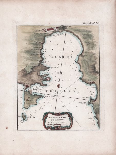
Carte du Golphe de l'Especy
Mode de Paiement
- PayPal
- Carte bancaire
- Virement bancaire
- Pubblica amministrazione
- Carta del Docente
Détails
- Année
- 1764
- Lieu d'édition
- Parigi
- Format
- 185 X 230
- Graveurs
- BELLIN Jacques Nicolas
Description
Carta nautica del Golfo di La Spezia, da Porto Venere a Lerici e con l'isola di Palmaria. Tavola tratta da: Le Petit Atlas Maritime Recueil De Cartes et Plans Des Quatre Parties Du Monde. en Cinq Volumes. I. Volume. Amerique Septentrionale et Isles Antilles. II. Volume. Amerique Meridionale. Mexique, Terra-Ferme, Bresil, Perou, Chily. III. Volume. Asia et Afrique. IV. Et V. Volumes. Europe et les Etats Qu'elle contient. Par Ordre de M. Le Duc de Choiseul, Colonel General des Suisses et Grisons Ministre de la Guerre et de la Marine. Par le S. Bellin Ingenieur de la Marine 1764.Acquaforte, magnifica coloritura a mano, in ottimo stato di conservazione.Carta nautica di piccolo formato, priva di data e firma. Proveniente dal quarto volume de Le Petit Atlas Maritime, un meraviglioso portolano di tutto il mondo di medio-piccolo formato, destinato più all’uso didattico che a quello pratico. Bellin fu un importante produttore di carte per il Dépôt des cartes et plans de la Marine. Il Neptune Francais fu pubblicato nel 1753 e l’Hydrographie Francaise nel 1756. Il suo lavoro più grande e completo è Le Petit Atlas Maritime, opera in 5 volumi illustrata da 581 carte, che copre le coste e importanti città portuali del mondo conosciuto; si tratta probabilmente della migliore raccolta di piani di città marittime e porti del suo tempo. Secondo Tooley, Bellin pubblicò una versione precedente di questo atlante nel 1763 intitolata Petit Atlas Francois. Il Duc de Choiseul fornì il supporto finanziario per la pubblicazione che gli valse la dedica. Étienne François de Choiseul (Nancy, 28 giugno 1719 - Castello di Chanteloup, 8 maggio 1785) è stato un diplomatico e politico francese, già ambasciatore a Roma e poi ministro degli esteri nel 1758, durante la guerra dei Sette anni. J. Arrivet è elencato come incisore nelle pagine dell’indice e dei titoli dell’atlante, e non si esclude che possa anche aver inciso le carte.Bibliografia National Maritime Museum, Catalogue of the Library - Vol. Three, Atlas & Cartography, Londra, 1971, pp. 236-238; R. Shirley, Maps in the Atlases of the British Library, Londra, 2004, pp. 1071-1072, M.BELL-5a. Nautical chart of the Gulf of La Spezia, from Porto Venere to Lerici and with the island of Palmaria. ' Map taken from: Le Petit Atlas Maritime Recueil De Cartes et Plans Des Quatre Parties Du Monde. en Cinq Volumes. I. Volume. Amerique Septentrionale et Isles Antilles. II. Volume. Amerique Meridionale. Mexique, Terra-Ferme, Bresil, Perou, Chily. III. Volume. Asia et Afrique. IV. Et V. Volumes. Europe et les Etats Qu'elle contient. Par Ordre de M. Le Duc de Choiseul, Colonel General des Suisses et Grisons Ministre de la Guerre et de la Marine. Par le S. Bellin Ingenieur de la Marine 1764.Etching, magnificent original colouring, in excellent condition.Small chart of the Mediterranean Sea, without date and signature. Coming from the fourth volume of "Le Petit Atlas Maritime", a wonderful pilot book from around the world of medium-small format, intended more for educational than for practical use.Bellin was an important map-maker for the Dépôt des cartes et plans de la Marine. The "Neptune Francais" was published in 1753 and the "Hydrographie Francaise" in 1756. His greatest and most complete Atlas is "Le Petit Atlas Maritime", a work in 5 volumes illustrated by 581 maps, covering the coasts and important port cities of the known world; it is probably the best collection of plans of maritime cities and ports of his time.According to Tooley, Bellin published an earlier version of this atlas in 1763 entitled "Petit Atlas Francois".The Duc de Choiseul provided financial support for the publication that earned him the dedication. Étienne François de Choiseul (Nancy, June 28th 1719 - Chanteloup Castle, May 8th 1785) was a French diplomat and politician, former ambassador to Rome and then foreign minister in 1758, during the Seven Years' War.J. Arrivet is listed as an engraver on the pages of the index and atlas titles, and it is not excluded that it may have also engraved the maps too.Bibliografia National Maritime Museum, Catalogue of the Library - Vol. Three, Atlas & Cartography, Londra, 1971, pp. 236-238; R. Shirley, Maps in the Atlases of the British Library, Londra, 2004, pp. 1071-1072, M.BELL-5a Cfr.