Carte Generale de l'Empire de Russie

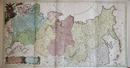
Carte Generale de l'Empire de Russie
Mode de Paiement
- PayPal
- Carte bancaire
- Virement bancaire
- Pubblica amministrazione
- Carta del Docente
Détails
- Année
- 1705
- Lieu d'édition
- Amsterdam
- Format
- 960 X 500
- Graveurs
- COVENS Johannes
- Description
- Koeman I: C&M 8:90, [C&M 10]
Description
Edizione di Covens & Mortier della mappa De L'Isle dell'Impero russo, pubblicata per la prima volta in "Atlas Russicus".La carta è tratta dal "Nieuwe Atlas, Inhoudennde vier Gedeeltens der Waereld ." di Covens & Mortier, questa grande mappa su 2 fogli mostra l'intero impero russo di Pietro il Grande, dalla Finlandia a ovest alla Kamchatka a est.Guillaume de l'Isle (1675-1726) era figlio di un cartografo e allievo di Jean Dominique Cassini, che, tra gli altri importanti contributi, allineò lo studio dell'astronomia allo studio della geografia. Sotto la direzione di Cassini, sono state effettuate osservazioni da località di tutto il mondo che hanno consentito di effettuare calcoli longitudinali con maggiore precisione. De l'Isle portò avanti questo lavoro impegnativo con notevole dedizione e integrità, rivedendo e migliorando costantemente le sue mappe. Sebbene la precisione fosse il suo obiettivo principale, le sue mappe sono sempre eleganti e attraenti.Covens & Mortier furono associati tra il 1721 e il 1778, rilevando l'attività di Pierrre Mortier. Johannes Covens e Cornelius Mortier erano cognati in seguito al matrimonio del primo con la sorella di Mortier, Agatha, nel 1721, quando formalmente si unirono anche loro. Sotto l'imprint Covens e Mortier, Cornelius e Jean ripubblicarono le opere dei grandi cartografi olandesi e francesi del XVII e dell'inizio del XVIII secolo quali De L'Isle, Allard, Jansson e De Wit.L'azienda sarebbe diventata una delle più prolifiche stamperie olandesi del XVIII secolo.Acquaforte su rame, magnifica coloritura d'epoca, in ottime condizioni. Covens & Mortier issue of the De L’Isle map of the Russia Empire, first published in the “Atlas Russicus”.From Covens & Mortier's "Nieuwe Atlas, Inhoudennde vier Gedeeltens der Waereld.”, this large map on 2 sheets, shows the whole of the Russian Empire of Peter the Great, from Finland in the West to Kamchatka in the East. Copper engraved vignette to left upper corner with title on banner; strap work cartouches to lower left corner with explanation. Guillaume de l'Isle (1675-1726) was the son of a cartographer and pupil of Jean Dominique Cassini, who, among other important contributions, aligned the study of astronomy to the study of geography. Under Cassini's direction, observations were made from locations all over the world that enabled longitudinal calculations to be made with much greater accuracy. De l'Isle carried on this exacting work with remarkable dedication and integrity, constantly revising and improving his maps. While precision was his primary goal, his maps are invariably elegant and attractive. Covens & Mortier as a firm existed between 1721-1778, taking over the business of Pierrre Mortier. Johannes / Jean Covens and Cornelius Mortier were brothers- in- law following the former's marriage to Mortier's sister Agatha in 1721, when they also formally went in to partnership. Under the Covens and Mortier imprint, Cornelius and Jean republished the works of the great 17th and early 18th century Dutch and French cartographers De L'Isle, Allard, Jansson, & De Wit. The firm would become one of the most prolific Dutch publishing concerns of the 18th century. Copperplate, full original colouring example, good condition. Cfr. Koeman I: C&M 8:90, [C&M 10]