Carte Historique et Cronologique et Geographique de l'Empire Romain, ou l'on fait Observer.
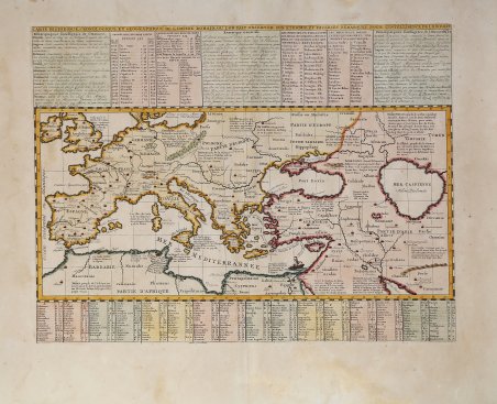
Carte Historique et Cronologique et Geographique de l'Empire Romain, ou l'on fait Observer.
Mode de Paiement
- PayPal
- Carte bancaire
- Virement bancaire
- Pubblica amministrazione
- Carta del Docente
Détails
- Année
- 1708
- Lieu d'édition
- Amsterdam
- Format
- 445 X 340
- Graveurs
- CHATELAIN Henri Abraham
- Thème
- Carte Storiche
Description
Carte Historique, Cronologique, et Geographique de l'Empire Romain, ou l'on Fait Observer son Etendue, et Diverses Remarques pour l'Intelligence de l'Histoire Bella carta che mostra l'intera estensione dell’Impero Romano in Europa, Asia e Africa settentrionale. La mappa è collegata a tabelle che forniscono informazioni su amministratori romani, imperatori, storici, poeti, ecc. Questa interessante carta storica di Chatelain illustra le regioni del Mediterraneo, del Mar Nero e del Mar Caspio che erano sotto il dominio romano. Chatelain fornisce dettagli approfonditi, comprese ampie note, rotte commerciali, nomi dei diversi regni, feudi, ecc. Vengono segnalate le principali città e le fortificazioni più importanti. Un elemento decorativo è presente nel Mediterraneo orientale sotto forma di una fregata e di una nave più piccola nelle vicinanze. Vengono nominate anche le antiche civiltà e vengono fornite note storiche sulla maggior parte di esse. Henri Abraham Chatelain (1684-1743) era un pastore ugonotto di origine parigina. Chatelain si dimostrò un uomo d'affari di successo, creando reti lucrative a Londra, L'Aia e poi ad Amsterdam. È noto soprattutto per l'Atlas Historique, pubblicato in sette volumi tra il 1705 e il 1720. Quest'opera enciclopedica era dedicata alla storia e alla genealogia dei continenti, trattando argomenti come la geografia, la cosmografia, la topografia, l'araldica e l'etnografia. Pubblicata grazie alla collaborazione tra Henri, suo padre Zacharie e suo fratello minore, anch'egli Zacharie, il testo è stato redatto da Nicolas Gueudeville, un geografo francese. Le mappe sono state realizzate da Henri, in gran parte sulla base del lavoro di Guillaume Delisle, e offrono al lettore generale una finestra sul mondo emergente del XVIII secolo. Carte Historique, Cronologique, et Geographique de l'Empire Romain, ou l'on Fait Observer son Etendue, et Diverses Remarques pour l'Intelligence de l'Histoire Fine map showing the full extent of the Roman Empire in Europe, Asia and northern Africa. The map is keyed to tables providing information on Roman administrators, emperors, historians, poets, etc. Size includes text panels. This interesting historical map by Chatelain depicts the regions of the Mediterranean, Black and Caspian Sea which were under Roman Rule. Chatelain provides in-depth detail including extensive notes , trade routes, names of the different kingdoms, fiefdoms, etc. Major cities and important fortifications are noted. A decorative element is in the eastern Mediterranean in the form of a frigate and a smaller vessel nearby. Ancient civilizations are also named and historical notes are provided regarding the majority of them. Henri Abraham Chatelain (1684-1743) was a Huguenot pastor of Parisian origins. Chatelain proved a successful businessman, creating lucrative networks in London, The Hague, and then Amsterdam. He is most well known for the ' Atlas Historique, published in seven volumes between 1705 and 1720. This encyclopedic work was devoted to the history and genealogy of the continents, discussing such topics as geography, cosmography, topography, heraldry, and ethnography. Published thanks to a partnership between Henri, his father, Zacharie, and his younger brother, also Zacharie, the text was contributed to by Nicolas Gueudeville, a French geographer. The maps were by Henri, largely after the work of Guillaume Delisle, and they offered the general reader a window into the emerging world of the eighteenth century. Cfr.