Carte Nouvelle des Terres de Cucan de Canara de Malabar de Madura et de Coromandel.
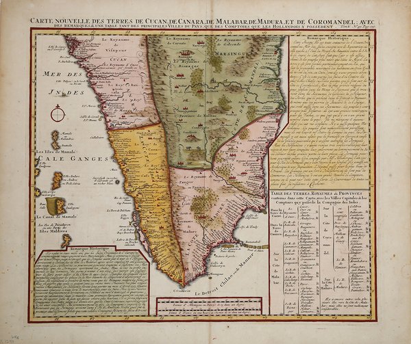

Carte Nouvelle des Terres de Cucan de Canara de Malabar de Madura et de Coromandel.
Mode de Paiement
- PayPal
- Carte bancaire
- Virement bancaire
- Pubblica amministrazione
- Carta del Docente
Détails
- Année
- 1708
- Lieu d'édition
- Amsterdam
- Format
- 440 X 380
- Graveurs
- CHATELAIN Henri Abraham
Description
Carta geografica inclusa nell'Atlas Historique, pubblicato ad Amsterdam tra il 1705 e il 1720. L'atlante, in 7 volumi, è innovativo per la sua epoca perché combina le mappe geografiche con incisioni e informazioni di carattere geografico, storico, etnografico e araldico. La mappa include tre caselle di testo che forniscono dettagli sulla regione e sulle sue divisioni. All'interno della mappa sono inclusi Ghati occidentali, animali selvaggi tra le foreste e colline. Realizzata sulla mappa di H. Reland (1676-1718), professore di Utrecht specializzato in lingue asiatiche, geografia e religioni.Incisione in rame, in ottime condizioni. Henri Abraham Chatelain (1684 - 1743) era un pastore ugonotto di origini parigine. È meglio conosciuto come cartografo olandese e più specificamente per il suo contributo cartografico nell’Atlas Historique ' in sette volumi, pubblicato ad Amsterdam tra il 1705 e il 1720. Innovativo per il suo tempo, l'Atlas Historique ' combinava incisioni e opere d'arte con studi di geografia, storia, etnologia, araldica e cosmografia. Alcuni studiosi suggeriscono che l'Atlas Historique ' non fu compilato esclusivamente da Henri Chatelain, come si crede comunemente, ma piuttosto fu un'impresa familiare che coinvolse Henri, suo padre Zacharie e suo fratello, sempre Zacharie. Map taken from "Atlas Historique" published in Amsterdam between 1705 and 1720. The map includes three text boxes giving particulars of the region and its divisions. Interior details include the Western Ghats and wild animals among the forests and hills.After a map by H.Reland (1676-1718) a Utrecht professor who specialized in Asian languages, geography and religions. Henri Abraham Chatelain (1684 - 1743) was a Huguenot pastor of Parisian origins. He is best known as a Dutch cartographer and more specifically for his cartographic contribution in the seminal seven volume ' Atlas Historique, published in Amsterdam between 1705 and 1720. Innovative for its time, the ' Atlas Historique ' combined fine engraving and artwork with scholarly studies of geography, history, ethnology, heraldry, and cosmography. Some scholarship suggests that the ' Atlas Historique ' was not exclusively compiled by Henri Chatelain, as is commonly believed, but rather was a family enterprise involving Henri, his father Zacharie and his brother, also Zacharie. Copper engraving, with fine later hand colour, in excellent condition. Cfr.