Carte réduite de la Mer du Nord comprenant les côtes orientales des Îles britanniques et les Cotes opposées du Continent
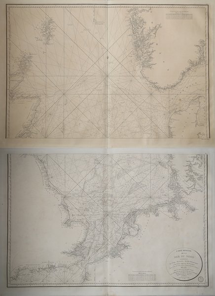

Carte réduite de la Mer du Nord comprenant les côtes orientales des Îles britanniques et les Cotes opposées du Continent
Mode de Paiement
- PayPal
- Carte bancaire
- Virement bancaire
- Pubblica amministrazione
- Carta del Docente
Détails
- Année
- 1807
- Lieu d'édition
- Parigi
- Format
- 0 X 0
- Graveurs
- Dépôt des cartes et plans de la Marine
Description
Grande mappa nautica, su due fogli, che raffigura il mare del Nord, compreso tra la Gran Bretagna a Ovest, le coste della Francia settentrionale, delle Fiandre, dei Paesi Bassi e della Frisia a S, le coste occidentali dello Jylland (Danimarca) e della Scandinavia (Norvegia) a Est. Si apre ampiamente a Nord verso l’Oceano Atlantico, con cui comunica tra le coste della Scozia e le isole Orcadi (Stretto di Pentland) e tra le isole Orcadi e le isole Shetland e tra queste ultime e la costa norvegese.Incisione su rame, in ottimo stato di conservazioneDue fogli da 945x615 mm. Large map, on two sheets, of the North sea, the northeastern arm of the Atlantic Ocean, located between the British Isles and the mainland of northwestern Europe. The sea is bordered by the island of Great Britain to the southwest and west, the Orkney and Shetland islands to the northwest, Norway to the northeast, Denmark to the east, Germany and the Netherlands to the southeast, and Belgium and France to the south. It is connected to the Atlantic by the Strait of Dover and the English Channel and opens directly onto the ocean between the Orkney and Shetland islands and between the Shetland Islands and Norway. The Skagerrak, an eastward extension of the North Sea between Norway and Denmark, connects the North and Baltic seas via the Kattegat and the Danish straits.Copperplate, in very good conditionTwo sheets of 945x615 mm. Cfr.