Central America
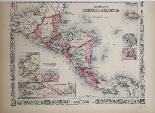
Central America
Mode de Paiement
- PayPal
- Carte bancaire
- Virement bancaire
- Pubblica amministrazione
- Carta del Docente
Détails
- Année
- 1865
- Lieu d'édition
- New York
- Format
- 395 X 310
- Graveurs
- JOHNSON Alvin Jewett
Description
Carta geografica tratta da "Johnson's New Illustrated Family Atlas, With Physical Geography, And With Descriptions Geographical, Statistical, And Historical … " edito a new York da Johnson & Ward. Acquaforte su lastra di zinco acciaiata, coloritura editoriale, in buone condizioni.La mappa descrive l'America Centrale dall'Istmo di Tehuantepec, in Messico, alla Baia di Panama. Mostra i paesi del Guatemala, dell'Honduras, del Salvador, del Nicaragua e del Costa Rica. La Giamaica appare nell'angolo in alto a destra. Sono inseriti strade città e fiumi. In basso a sinistra sono inseriti tre inseri con le mappe dell'Istmo di Panama, della Nicaragua Route fino al Pacifico e del porto di San Juan de Nicaragua. Due inserti aggiuntivi sul lato destro della mappa mostrano Aspinwall City e la città di Panama. Map taken from Johnson's New Illustrated Family Atlas, With Physical Geography, And With Descriptions Geographical, Statistical, And Historical … By Richard Swainson Fisher, M.D. … Maps Compiled, Drawn, And Engraved Under The Supervision Of J.H. Colton And A.J. Johnson. New York: Johnson And Ward, Successors To Johnson And Browning (Successors To J.H. Colton And Company,) No. 113 Fulton Street. 1865. Entered … One Thousand Eight Hundred and Sixty-four, by A.J. Johnson … New York. Good conditions.Covers Central America from the Isthmus of Tehuantepec, Mexico to the Bay of Panama. Shows the countries of Guatemala, Honduras, el Salvador, Nicaragua, and Costa Rica. Jamaica appears in the upper right corner. Shows proposed roadways, cities, rivers, and ferry crossings. The lower left hand quadrant features three inset maps. In a clockwise fashion from top left these detail the Isthmus of Panama, the Nicaragua Route to the Pacific, and the Harbor of San Juan de Nicaragua. Two additional insets on the right hand side of the map show Aspinwall City and the City of Panama. Cfr.