Cypri Insulae Nova Descript
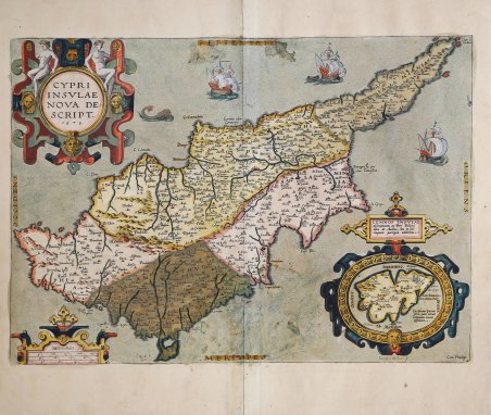
Cypri Insulae Nova Descript
Mode de Paiement
- PayPal
- Carte bancaire
- Virement bancaire
- Pubblica amministrazione
- Carta del Docente
Détails
- Année
- 1573
- Lieu d'édition
- Anversa
- Format
- 500 X 350
- Graveurs
- ORTELIUS Abraham
Description
Titolo nel cartiglio in alto a sinistra: CYPRI | INSVLAE | NOVA DE:|SCRIPT. | "1573". Al lato destro (75 x 100 mm, forma ovale e scala 1 : 400,000:): “LEMNOS INSVLAE descriptionem ex Petri Bellonij libro de Auibus, hoc in loco | tanquam parergon adiecimus". Magnifica e importante carta dell’isola di Cipro, inciso da Iohannes van Deutecom: "Ioannes a Deutecum f. Cum Priuilegio". Esemplare del terzo stato di quattro secondo Van den Broecke: dall’edizione latina del 1592 la linea di costa è più pesantemente ombreggiata e le onde del mare sono sostituite da punti. Le onde originali si possono ancora distinguere dietro la nuova puntinatura fino al 1603. Dalla rara edizione italiana del Theatrum Orbis Terrarum stampata ad Anversa da Jean Baptiste Vrients nel 1608 e poi nel 1612. La carta si basa sull'opera di Giacomo Franco, stampata a Venezia nel 1570. (Meurer p. 97-98). L'isola di Lemnos, disegnata dallo stesso Ortelio, si basa su un resoconto scritto di Pierre Belon del 1555. (Meurer p. 113-114). Questa mirabile carta dell’isola sostituì completamente il prototipo di Pagano e divenne il nuovo modello di carta di Cipro, grazie a Ortelius; divenne lo standard subito dopo la sua pubblicazione e rimase insuperata, sia nei contorni che nei contenuti, fino al 1885, quando il cartografo britannico Horatios Herbert Kitchener pubblicò a Londra la sua carta di Cipro, dopo aver condotto un rilevamento trigonometrico. Il Theatrum Orbis Terrarum ' è considerato il primo vero “atlante” moderno. L’opera fu pubblicata in 7 lingue e 36 edizioni, per il quale – nel 1570 - Ortelius ottenne il ' privilegio, ovvero una sorta di diritto d'autore che impediva ad altri cartografi di pubblicare i propri lavori. Il ' Theatrum ' rappresentava il lavoro più avanzato del lavoro della descrizione cartografica. L’Ortelius vi raccolse il sapere geografico e cartografico del suo tempo, proponendo in 147 spettacolari tavole incise l’immagine più fedele del mondo allora conosciuto e, in alcune straordinarie “carte storiche”, regioni e itinerari tratti dalla letteratura, dalla mitologia, dalla tradizione. Ortelius fu anche il primo a citare le fonti, menzionando i nomi dei cartografi nel “catalogus auctorum”. Dal 1598 al 1612 le edizioni postume del ' Theatrum ' furono realizzate dal suo collaboratore Johannes Baptiste Vrients. Acquaforte, finemente colorata in epoca, minime ossidazioni, per il resto in buono stato di conservazione. Bibliografia Van den Broecke, M.: Ortelius Atlas Maps, No. 149; Zacharakis, C.G.: A Catalogue of Printed Maps of Greece, 1477-1800, No. 2490/1614; Van der Krogt, P.: Koeman's Atlantes Neerlandici, 8130:31B.1. CYPRI | INSVLAE | NOVA DE:|SCRIPT. | "1573". At lower right an Inset (75 x 100 mm, oval shape, scale 1 : 400,000:): “LEMNOS INSVLAE descriptionem ex Petri Bellonij libro de Auibus, hoc in loco | tanquam parergon adiecimus". Engraved by Iohannes van Deutecom: "Ioannes a Deutecum f. Cum Priuilegio”. Example of the third state of four according Van den Broecke: “in 1592L the coastline is more heavily shaded, and the waves in the sea are replaced by dots. The original waves can still be discerned behind the new stippling as late as 1603”. From the rare Italian edition of ' Theatrum Orbis Terrarum ' printed in Antwerp by Jean Baptiste Vrients in 1608 and then in 1612. The map is based on the work by Giacomo Franco, Venice 1570. (Meurer p. 97-98). The island of ' Lemnos, drew by Ortelius himself, is based on a written account by Pierre Belon 1555. (Meurer p. 113-114). This admirable map completely ' replaced ' Pagano’s prototype map, became the new model map of Cyprus, thanks to Ortelius; the island of Lemnos appears within a cartouche at the bottom right corner of the map. This particular map became the standard soon after its publication, and it remained unsurpassed, in both outline and contents, until 1885, when British cartographer Horatios Herbert Kitchener ' published ' his ' map ' of ' Cyprus, ' in London, after conducting a trigonometric survey of the island. ' The ' Theatrum Orbis Terrarum is considered the first true modern "Atlas". The work was published in 7 languages and 36 editions, for which - in 1570 - Ortelius obtained the privilege, a kind of copyright that prevented other cartographers from publishing his works. The ' Theatrum ' represented the most advanced work of cartographic description. Ortelius collected in it the geographical and cartographic knowledge of his time, proposing in 147 spectacular engraved plates the most faithful image of the world then known and, in some extraordinary "historical maps", regions and routes taken from literature, mythology, tradition. Ortelius was also the first to cite sources, mentioning the names of cartographers in the "catalogus auctorum". From 1598 to 1612 the posthumous editions of the ' Theatrum ' were made by his collaborator Johannes Baptiste Vrients. Copper engraving, contemporary coloring, in good condition. Bibliografia Van den Broecke, M.: Ortelius Atlas Maps, No. 149; Zacharakis, C.G.: A Catalogue of Printed Maps of Greece, 1477-1800, No. 2490/1614; Van der Krogt, P.: Koeman's Atlantes Neerlandici, 8130:31B.1 Cfr.