Decima Europe Tabula
Decima Europe Tabula | Gravures | GERMANUS Donnus Nicolaus
Decima Europe Tabula
Decima Europe Tabula | Gravures | GERMANUS Donnus Nicolaus
Mode de Paiement
- PayPal
- Carte bancaire
- Virement bancaire
- Pubblica amministrazione
- Carta del Docente
Détails
- Année
- 1486
- Lieu d'édition
- Ulm
- Format
- 550 X 365
- Graveurs
- GERMANUS Donnus Nicolaus
- Thème
- Grecia
Description
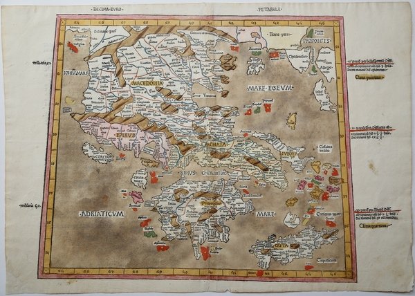
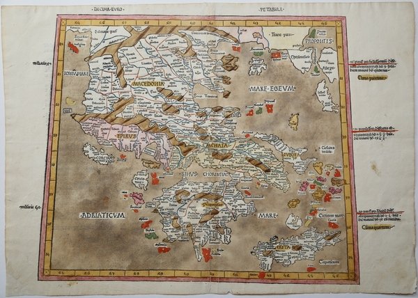
La Decima Europe Tabula dall'edizione di Johann Reger della Geographia di Tolomeo Rarissima mappa a proiezione trapezoidale, dall'edizione del 1486 della Geographia stampata a Ulm. Nel 1482 Lienhart Holle di Ulm pubblicò un'edizione riveduta della Geographia di Tolomeo con la rielaborazione del corpus tolemaico da parte del cartografo Nicolaus Germanus Donis. L'atlante includeva cinque mappe "moderne" aggiuntive: Italia, Spagna, Francia, Scandinavia e Terra Santa. L'atlante sarebbe stato il primo libro stampato da Lienhart Holle, tuttavia, sembra che l'impresa si sia rivelata rovinosamente costosa e la sua attività fallì poco dopo la pubblicazione. I fogli rimanenti, le matrici in legno e i caratteri tipografici passarono a Johann Reger di Ulm, che ripubblicò l'opera nel 1486. Oltre alle mappe âmoderneâ, l'atlante presenta un'altra notevole novità ; per la prima volta le mappe vennero realizzate tramite lâincisione su legno, intagliate da Johannes di Armsheim, che firmò la mappa del mondo, incorporando una âNâ rovesciata nel testo inciso su legno di ogni mappa. Fu anche il primo a stampare il testo di accompagnamento sul retro della mappa a cui si riferisce. Un'altra caratteristica importante delle edizioni di Ulm è l'introduzione della colorazione da parte dell'editore sulle mappe; una sorta di coloritura editoriale. Le mappe del 1482 presentavano solitamente un ricco colore blu per il mare, che fu sostituito da un tenue colore marrone nellâedizione del 1486. La storia della Decima Europe Tabula viene ben raccontata da George Tolias: âIn Ptolemy's Geographia and the mappaemundi, in the maritime charts and the fifteenth-century humanistic Isolarii, Greece is present everywhere and nowhere. The territories inhabited and named by Greeks are regularly mentioned and sometimes even described in detail. Yet Greece does not emerge yet as a distinct regional entity. [â¦] The reception of Ptolemy's Geographia in the West and its influence in shaping the modern worldview is a complex question of permanent interest to the historian, as it involves a wide range of key issues relating to the rational perception and mathematical representation of space, the definition of its regional structure and the exploration of its history. [â¦] From as early as the fifteenth century, attempts were made to produce modern maps of various regions based on Ptolemy's system. Renaissance cartographers began to supplement the original corpus of ancient tabulae with modern regional maps, and Sebastiano Gentile has made an extensive study of how new maps were added to the Latin manuscripts of the Geographia. In 1466 Nicolaus Germanus began to produce manuscript couples of Ptolemy's treatise with an additional projection, as well as modern "Ptolemaic" maps of Spain, France, Italy, northern Europe and the Holy Land. This "updating" process reached a peak in the closing years of the fifteenth century, when Henricus Martellus Germanus produced his luxurious manuscript large-format edition in which the Ptolemaic tabulae of Europe and of the Mediterranean regions of Asia and Africa alternate with modern maps of the same regions. In this way Tabulae IX and X of Europe are followed by a modern map of the Balkan peninsula, which closely resembles those included in the isolarii of Henricus Martellus and the comparable map by Francesco Roselliâ (cfr. George Tolias, Mapping Greece, p. 61). Xilografia con magnifica coloritura coeva, impressa su carta vergata coeva, minimi restauri alla piega centrale perfettamente eseguiti, per il resto in ottimo stato di conservazione. Bibliografia G. Tolias, Mapping Greece, n. 1233; Zacharakis, A Catalogue of Printed Maps of Greece, n. 2768.