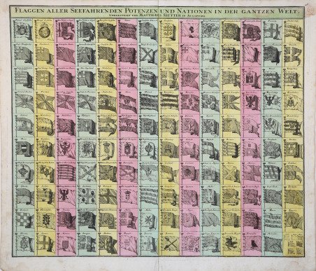
Flaggen Aller Seefahrenden Potenzen und Nationen in Der Gantzen Welt
Flaggen Aller Seefahrenden Potenzen und Nationen in Der Gantzen Welt | Gravures | SEUTTER "il vecchio" Matthaus

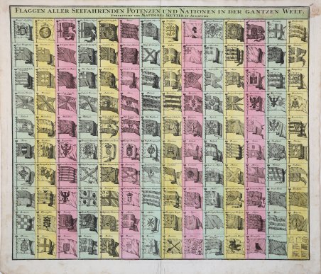
Flaggen Aller Seefahrenden Potenzen und Nationen in Der Gantzen Welt
Flaggen Aller Seefahrenden Potenzen und Nationen in Der Gantzen Welt | Gravures | SEUTTER "il vecchio" Matthaus
Mode de Paiement
- PayPal
- Carte bancaire
- Virement bancaire
- Pubblica amministrazione
- Carta del Docente
Détails
- Année
- 1730
- Lieu d'édition
- Augsburg
- Format
- 582 X 500
- Graveurs
- SEUTTER "il vecchio" Matthaus
- Thème
- Carte Nautiche
Description
Affascinante tavola di bandiere pubblicata da Matthias Seutter circa nel 1740. La tavola presenta 139 bandiere di varie nazioni, fazioni e compagnie commerciali. Tra le bandiere più interessanti ci sono quelle della Compagnia Olandese delle Indie Occidentali (G.W.C. /Geoctroyeerde Westindische Compagnie) e della Compagnia Olandese delle Indie Orientali (V.O.C. / Vereenigde Oostindische Compagnie). Il primo posizionamento delle bandiere inglesi nel quadrante superiore sinistro suggerisce che questa carta potrebbe essere stata copiata da una fonte inglese, anche se probabilmente derivata da una carta delle bandiere olandesi pubblicata da Cornelis Danckerts intorno al 1700. La carta fu ripresa da J. B. Homann, che pubblicò una propria variante intorno al 1710. Quando Seutter lasciò la ditta Homann all'inizio del XVIII secolo, potrebbe aver portato con sé questa tavola o averla semplicemente copiata. Matthäus Seutter (1678 - 1757) fu uno dei più importanti e prolifici editori tedeschi di mappe del XVIII secolo. Attivo, come incisore sotto la tutela dell'importante J. B. Homann. All'inizio del 1700 Seutter lasciò Homann per tornare ad Augusta, dove lavorò per l'importante editore d'arte Jeremia Wolff (1663 - 1724), per il quale incise mappe e altre stampe. Intorno al 1717 fondò la propria casa editrice cartografica indipendente ad Augusta. La maggior parte delle mappe di Seutter sono pesantemente basate, se non addirittura copie, di lavori precedenti fatti dalle calcografie Homann e De L'Isle. Ciononostante, dal 1731/32 Seutter era uno degli editori più prolifici del suo tempo e fu onorato dall'imperatore tedesco Carlo VI che gli diede il titolo di Geografo Imperiale, dopo il quale la maggior parte delle mappe successive includeva la denominazione Avec Privilege. Seutter continuò a pubblicare fino alla sua morte, all'apice della sua carriera, nel 1757. Acquaforte con coloritura editoriale, in ottimo stato di conservazione. A very attractive c. 1765 flag chart issued by Matthias Seutter. The plate features 139 flags of various nations, factions, and trading companies. Among the more interesting flags are those of the Dutch West India Company (G.W.C. /Geoctroyeerde Westindische Compagnie) and the Dutch East India Company (V.O.C. / Vereenigde Oostindische Compagnie). The premier placement of English flags in the upper left quadrant suggest that this chart may have been copied from an English source. This map is probably derived from a Dutch flag chart issued by Cornelis Danckerts c. 1700. The chart was picked up by J. B. Homann, who issued in own variant c. 1710. When Seutter left the Homann firm early in the 18th century, he may have taken this plate with him or simply copied it. Seutter issued his own variant sometime after 1737, as the chart notes his privilege, a kind of early copyright suggestive of royal patronage, at top center. Mattha?us Seutter (1678 - 1757) was one of the most important and prolific German map publishers of the 18th century. Seutter was born the son of a goldsmith but apprenticed as a brewer. Apparently uninspired by the beer business, Seutter abandoned his apprenticeship and moved to Nuremberg where he apprenticed as an engraver under the tutelage of the prominent J. B. Homann. Sometime in the early 1700s Seutter left Homann to return to Augsburg, where he worked for the prominent art publisher jeremiad Wolff (1663 - 1724), for whom he engraved maps and other prints. Most of Seutter's maps are heavily based upon, if not copies of, earlier work done by the Homann and De L'Isle firms. Nonetheless, by 1731/32 Seutter was one of the most prolific publishers of his time and was honored by the German Emperor Karl VI who gave him the title of Imperial Geographer, after which most subsequent maps included the Avec Privilege designation. Copperplate with fine original colouring, good condition. Cfr.
