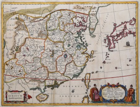
Imperium Sinicum Quindecupartitum. Imperium Sinicum in XV regna seu provincias distributum una cum genuino situ urbium metropolitanarum montium fluminum lacum Bella antica mappa di Cina, Corea e Giappone, dalla prima edizione di China Illustrata di Kircher. La mappa di Kircher di Cina, Corea e Giappone si basa sul lavoro compilato dal gesuita padre Martino Martini. La mappa di padre Martini è stata raccolta da fonti cinesi tra il 1643 e il 1650. La pubblicazione della mappa Martini ha notevolmente migliorato la conoscenza europea della regione, comprese le posizioni corrette di molte città e le caratteristiche topografiche. Viene annotata la rotta commerciale tra Canton e Pechino e la Grande Muraglia e il deserto del Gobi sono entrambi rappresentati graficamente. Athanasius Kircher (1601-1680) fu uno dei più grandi studiosi e scrittori di viaggi del suo tempo. Studioso gesuita di origine tedesca, è stato descritto come inventore, compositore, geografo, geologo, egittologo, storico, avventuriero, filosofo, proprietario di uno dei primi musei pubblici, fisico, matematico, naturalista, astronomo, archeologo e autore di più di 40 opere pubblicate. Kircher iniziò a insegnare matematica, etica e lingue antiche all'Università di Würzburg. Nel 1630 e nel 1637 Kircher fece una petizione per recarsi in Cina, ma non ebbe successo in entrambe le richieste, invece, la sua China Illustrata, pubblicata per la prima volta nel 1667, era una raccolta delle opere più importanti del periodo, tra cui l'Atlante della Cina di Martino pubblicato da Blaeu (1655), e i Diari di Matteo Ricci (1552-1610), Alvaro Semedo (1586-1658), Michael Boym (1612-1659 e Melchisedech Thevenot. Acquaforte, impressa su carta vergata coeva, finemente colorata a mano, consuete pieghe di carta, minimi restauri nel cartiglio in basso, nel complesso in buono stato di conservazione. Bibliografia Marco Caboara, Regnum Chinae: The Printed Western Maps of China to 1735, 64.2, 65; NORDENSKIOLD: Vol III 520. Imperium Sinicum Quindecupartitum. Imperium Sinicum in XV regna seu provincias distributum una cum genuino situ urbium metropolitanarum montium fluminum lacum Fine early map of China, Korea and Japan, from the first edition of Kircher's China Illustrata. Kircher's map of China, Korea and Japan is based on the work compiled by Jesuit Father Martino Martini. Father Martini's map was gathered from Chinese sources between 1643 and 1650. The publication of theMartiini map greatly advanced European knowledge of the region including the correct locations of many cities and topographical features. The trade route between Canton and Peking is noted and the Great Wall and the Gobi Desert are both graphically pictured. There were two editions of this map, this being the more decorative of the two, including images of 2 indigenous Chinese men and a more decorative title cartouche than the other edition. From Kircher's book on China; illustrates land & sea trade routes from Middle East to China. Athanasius Kircher (1601-1680) was one of the great scholars and travel writers of his time. A German born Jesuit scholar, he has been described as inventor, composer, geographer, geologist, Egyptologist, historian, adventurer, philosopher, proprietor of one of the first public museums, physicist, mathematician, naturalist, astronomer, archaeologist, and author of more than 40 published works. Kircher began teaching mathematics, ethics, and ancient languages at the University of Würzburg. In 1630 and 1637, Kircher petitioned to travel to China, but was unsuccessful in both requests, instead, his China Illustrata, first published in 1667, was a compilation of the most important works of the period, including Martino's Atlas of China published by Blaeu (1655), and the Journals of Matteo Ricci (1552-1610), Alvaro Semedo (1586-1658), Michael Boym (1612-1659 and Melchisedech Thevenot. Etching, printed on contemporary laid paper, finely colored by hand, usual paper folds, minor restorations in the lower cartouche, overall in good condition. Bibliografia Marco Caboara, Regnum Chinae: The Printed Western Maps of China to 1735, 64.2, 65; NORDENSKIOLD: Vol III 520.

 Découvrez comment utiliser
 Découvrez comment utiliser