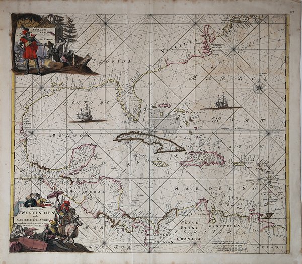
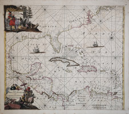
Indiarum Occidentalium Tractus Littorales cum Insulis Caribicis - Pascaert van Westindien ende Caribise Eylanden
Indiarum Occidentalium Tractus Littorales cum Insulis Caribicis - Pascaert van Westindien ende Caribise Eylanden
Mode de Paiement
- PayPal
- Carte bancaire
- Virement bancaire
- Pubblica amministrazione
- Carta del Docente
Détails
- Année
- 1680
- Lieu d'édition
- Amsterdam
- Format
- 572 X 490
- Graveurs
- WIT Frederick de
- Description
- Burden, P, The Mapping of North America II, #468, State 2.
Description
Seconda edizione della carta nautica del 1680 di Frederick de Wit, una mappa marittima delle Indie Occidentali, dell'America Centrale, del Golfo del Messico e della Florida. La mappa offre una rappresentazione abbastanza dettagliata delle isole delle Indie Occidentali, della Florida e dell'America centrale. La costa americana a nord della Florida è esageratamente inclinata verso nord-est, un errore che sarebbe stato corretto all'inizio del XVIII secolo. Allo stesso modo, lo Yuchatan appare in una rappresentazione errata comune alla maggior parte delle mappe olandesi fino alla fine del XVIII secolo. Si noti che il delta del fiume Mississippi non è stato ancora identificato, ma numerosi nomi di luoghi lungo la costa sono rappresentati, seppur in modo congetturale. Il tutto è pieno di linee lossodromiche e illustrazioni di galeoni. Cartograficamente la mappa è parzialmente derivata da quella di Hessel di Gerritsz del 1631 con gli aggiornamenti derivati ?dalla mappa di Joannes van Loon del 1661. Questa mappa fu pubblicata nell'Orbis Maritimus ofte Zee Atlas di de Wit del 1680. Fu incisa da Romeyn de Hooghe. La seconda edizione può essere identificata dalla presenza della costa occidentale del Centro America e dall'aggiunta di New Amsterdam nel quadrante in alto a destra. Due edizioni successive furono pubblicate da Louis Renard e dalla famiglia Ottens. Tutte le edizioni di questa mappa sono rare. Frederick de Wit (1630 circa - 1706) era un cartografo ed editore, originario di Gouda. Si trasferì ad Amsterdam nel 1648, studiando sotto la direzione della famiglia Blaeu e, nel 1654 iniziò la propria attività, aprendo una tipografia con insegna “I tre granchi”, che in seguito cambiò in “The White Chart”. Nel 1660 pubblicò la sua mappa del mondo, Nova Totius Terrarum Orbis Tabula, realizzata sia come mappa murale che come riduzione in formato da atlante in-folio (cfr. Shirley, The Mapping of the World, n. 444). Due anni dopo iniziò a stampare atlanti che venivano assemblati essenzialmente su esigenza del committente, alcuni dei quali comprendevano oltre 150 mappe. Dopo aver sposato Maria van der Way, originaria di Amsterdam, de Wit ottenne i privilegi di cittadino e divenne membro della corporazione di città di San Luca, nel 1664. Nel 1675 pubblica il suo sontuoso atlante nautico, Orbis Maritimus ofte Zee Atlas, noto anche per la sua decorazione elaborata. Nel 1695, pubblica un libro di vedute della città dei Paesi Bassi, Perfekte aftekeningen der steden van del XVII Nederlandsche provincien. Dopo la morte di de Wit, la sua vedova, Maria, continuò l’attività fino al 1710. Il loro figlio, Franciscus, era un commerciante di pesce e non aveva interesse per il negozio di mappe. La tipografia fu, quindi, venduta in asta e la maggior parte delle lastre venne acquistata da Pieter Mortier. Le 27 tavole del suo atlante nautico del 1675 furono successivamente vendute, in un’asta nel 1710, al tipografo e libraio di Amsterdam Louis Renard che le pubblicò con il proprio nome e con alcune modifiche nel 1715. Acquaforte, bella coloritura coeva, piccole ossidazioni, per il resto in ottimo stato di conservazione. Bibliografia Koeman ' Atlantes Neerlandici IV, pp.518-19; ' Burden, P, The Mapping of North America II, #468, State 2. A fine and rare old color example of the second edition of Frederick de Wit's 1680 nautical chart or maritime map of the West Indies, Central America, Gulf of Mexico, and Florida. Printed during the Golden Age of Caribbean Piracy, this sea chart covers the eastern coast of North America from Cape May and the Chesapeake Bay to Central America and the Spanish Main. It offers a reasonably detailed depiction of the West India Islands, Florida, and Central America. The American seaboard north of Florida is exaggerated in its northeasterly inclination, an error that would be corrected in the early 18th century. Similarly, the Yuchatan appears in a narrow configuration common in most Dutch maps until the late 18th century. Note the Mississippi River Delta has not yet been identified, but numerous place names along the coast are identified, if only conjecturally. The whole is filled with rhumb lines and illustrations of galleons. Cartographically the map was partially derived from Hessel's Gerritsz's map of 1631 with updates derived from Joannes van Loon's map of 1661. This map was published in de Wit's Orbis Maritimus ofte Zee Atlas of 1680. It was engraved by Romeyn de Hooghe. The second edition can be identified by the presence of the western coast of Central America and the addition of New Amsterdam in the upper right quadrant. Two subsequent editions were issued by L. Renard and the Ottens family. All editions of this map are scarce. Frederick de Wit (c. 1630 - 1706) was a cartographer and publisher, originally from Gouda. He moved to Amsterdam in 1648, studying under the Blaeu family, and in 1654 started his own business, opening a print shop under the sign "The Three Crabs," which he later changed to "The White Chart." In 1660 he published his map of the world, Nova Totius Terrarum Orbis Tabula, produced both as a wall map and as a reduction to an in-folio atlas format (see Shirley, The Mapping of the World, no. 444). Two years later he began printing atlases that were assembled essentially to the customer's requirements, some of which included more than 150 maps. After marrying Maria van der Way, a native of Amsterdam, de Wit obtained citizen privileges and became a member of the city guild of St. Luke's in 1664. In 1675 he published his lavish nautical atlas, Orbis Maritimus ofte Zee Atlas, also known for its elaborate decoration. In 1695, he published a book of city views of the Netherlands, Perfekte aftekeningen der steden van del XVII Nederlandsche provincien. After de Wit's death, his widow, Maria, continued the business until 1710. Their son, Franciscus, was a fish merchant and had no interest in the map store. The print shop was, therefore, sold at auction and most of the plates were purchased by Pieter Mortier. The 27 plates of his 1675 nautical atlas were later sold at auction in 1710 to the Amsterdam printer and bookseller Louis Renard, who published them under his own name and with some modifications in 1715. Copperplate with fine original colour, light foxing, otherwise very good condition. Bibliografia Koeman ' Atlantes Neerlandici IV, pp.518-19; ' Burden, P, The Mapping of North America II, #468, State 2. Cfr.