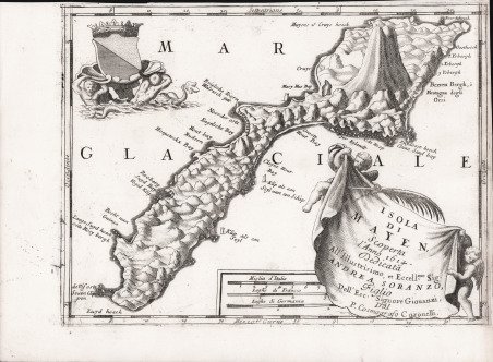
Isola di Mayen, Scoperta l'anno 1614. Dedicata All'Illustrissimo, et. Eccell.mo Sig. Andrea Soranzo.
Isola di Mayen, Scoperta l'anno 1614. Dedicata All'Illustrissimo, et. Eccell.mo Sig. Andrea Soranzo.
Mode de Paiement
- PayPal
- Carte bancaire
- Virement bancaire
- Pubblica amministrazione
- Carta del Docente
Détails
- Année
- 1690
- Lieu d'édition
- Venezia
- Format
- 314 X 235
- Graveurs
- CORONELLI Vincenzo
Description
Carta geografica di Jan Mayen tratta dal "Corso Geografico Universale"; la mappa di Coronelli celebra la sua scoperta nel 1614. L'isola di Jan Mayen è un territorio appartenente alla Norvegia, costituito da un'isola situata al limite tra l'Oceano Atlantico e il Mar Glaciale Artico e sotto l'amministrazione della Contea di Nordland. ' La prima scoperta dell'isola fu nel 1614. Ci sono rivendicazioni di scoperte precedenti: alcuni storici credono che un monaco irlandese, Brendan, che era conosciuto come un buon marinaio, era vicino a Jan Mayen all'inizio del sesto secolo. Tornò da uno dei suoi viaggi e riferì di essere stato vicino a un'isola nera, che era in fiamme, e c'era un rumore terribile nella zona. Pensò che avrebbe potuto trovare l'entrata dell'inferno. Jan Mayen fu scoperto nell'estate del 1614 da tre spedizioni separate. L'olandese Fopp Gerritsz, mentre era al comando di una spedizione di caccia alla balena inviata dall'inglese John Clarke, di Dunkerque, dichiarò (nel 1631) di aver scoperto l'isola il 28 giugno e la chiamò "Isabella". ' A gennaio la Noordsche Compagnie (società nordica), modellata sulla compagnia olandese delle Indie orientali, era stata creata per sostenere la caccia alle balene olandesi nell'Artico. Due delle sue navi, finanziate dai mercanti di Amsterdam e Enkhuizen, raggiunsero Jan Mayen nel luglio 1614. I capitani di queste navi: Jan Jacobszoon May van Schellinkhout sul Gouden Cath (Golden Cat) e Jacob de Gouwenaer sull'Orangienboom (Orange Tree) - lo chiamò Mr. Joris Eylant dopo il cartografo olandese Joris Carolus che era a bordo e mappò l'isola.I capitani hanno riconosciuto che una terza nave olandese, la Cleyn Swaentgen (Little Swan) capitanata da Jan Jansz Kerckhoff e finanziata da azionisti della compagnia Noordsche Compagnie di Delft, era già stata sull'isola quando sono arrivati. Avevano ipotizzato che quest'ultimo, che chiamò l'isola Maurits Eylandt (o Mauritius) dopo che Maurice di Nassau, Principe d'Orange, avrebbe riferito la loro scoperta agli Stati Generali. Tuttavia, i mercanti di Delft avevano deciso di mantenere la scoperta segreta e tornarono nel 1615 per cercare il proprio profitto. La controversia che ne seguì fu risolta solo nel 1617, anche se nel frattempo a entrambe le compagnie fu permesso di balene a Jan Mayen. Incisione in rame, in ottimo stato di conservazione. Map taken from "Corso Geografico Universale". Scarce decorative map of Jan Mayen Island, a volcanic island in the Atlantic Ocean. Coronelli's map of Jan Mayen celebrates its discovery in 1614. The first known discovery of the island was in 1614. There are claims of earlier discoveries: some historians believe an Irish monk, Brendan, who was known as a good sailor, was close to Jan Mayen in the early sixth century. He came back from one of his voyages and reported he had been close to a black island, which was on fire, and there was a terrible noise in the area. He thought he might have found the entrance to hell. ' Jan Mayen was discovered in the summer of 1614, probably within one month, by three separate expeditions. The Dutchman Fopp Gerritsz, while in command of a whaling expedition sent out by the Englishman John Clarke, of Dunkirk, claimed (in 1631) to have discovered the island on June 28 and named it "Isabella". In January the Noordsche Compagnie (Northern Company), modeled on the Dutch East India Company, had been established to support Dutch whaling in the Arctic. Two of its ships, financed by merchants from Amsterdam and Enkhuizen, reached Jan Mayen in July 1614. The captains of these ships-Jan Jacobszoon May van Schellinkhout on the Gouden Cath (Golden Cat) and Jacob de Gouwenaer on the Orangienboom (Orange Tree)-named it Mr. Joris Eylant after the Dutch cartographer Joris Carolus who was on board and mapped the island. The captains acknowledged that a third Dutch ship, the Cleyn Swaentgen (Little Swan) captained by Jan Jansz Kerckhoff and financed by Noordsche Compagnie shareholders from Delft, had already been at the island when they arrived. They had assumed the latter, who named the island Maurits Eylandt (or Mauritius) after Maurice of Nassau, Prince of Orange, would report their discovery to the States General. However, the Delft merchants had decided to keep the discovery secret and returned in 1615 to hunt for their own profit. The ensuing dispute was only settled in 1617, though both companies were allowed to whale at Jan Mayen in the meantime. Cfr.