Italiae Veteris Specimen
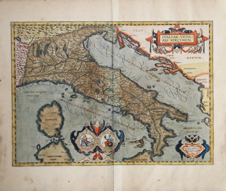
Italiae Veteris Specimen
Mode de Paiement
- PayPal
- Carte bancaire
- Virement bancaire
- Pubblica amministrazione
- Carta del Docente
Détails
- Année
- 1595
- Lieu d'édition
- Anversa
- Format
- 490 X 350
- Graveurs
- ORTELIUS Abraham
- Thème
- Carte Storiche
Description
Carta dell’Italia antica tratta dal Parergon Theatri Orbis Terrarum, il primo atlante storico del mondo antico. Dall’edizioni del Parergon successive al 1595 questa mappa sostituisce la precedente versione dell’Italiae Veteris Specimen con il nome “ITALIA” nel cartiglio in basso a sinistra. Esemplare tratto dalla rara edizione italiana del Theatrum Orbis Terrarum stampata ad Anversa da Jean Baptiste Vrients nel 1608 e quindi nel 1612. Nel cartiglio in basso a destra, la notizia del privilegio: Cum Priuilegio | Imp. Reg. et Cancellariæ Bra:|bantiæ decennali, evulgabat | Abrahamus Ortelius. ' Nel cartiglio in basso, al centro, a sinistra: VESPASIANI AVG. EX NVMMO ÆREO IMP. CÆS. | ROMA. Nel cartiglio in basso, al centro, a destra: ANTONINI PII AVG. EX NVMMO ÆREO IMP. CÆS. ITALIA. Per realizzare questa carta dell’Italia Antica Ortelius si è basato sulla mappa di Giacomo Gastaldi del 1561 (Meurer p. 148-154, Karrow 30/90, p. 216-249) integrandola con fonti letterarie classiche: Virgilio, Plinio, Eliano, Aethicus, Strabone, Polibio e Varrone. Stato unico. La lastra su cui è stata incisa è conservata presso il museo Plantin-Moretus di Anversa. Circa una decade dopo la pubblicazione del “moderno” Theatrum Orbis Terrarum, Ortelius rispose alle “preghiere di amici e studiosi di storia antica, sacra e profana” e compilò una serie di mappe di soggetto biblico e classico, quasi tutte disegnate da lui. Intitolò l’opera “Parergon theatri”, ovvero “aggiunta, appendice, del Theatrum”, ma al tempo stesso anche complementare al Theatrum: il Paregon theatri forniva per il mondo antico lo stesso materiale che Ortelius aveva fornito per il mondo moderno con il Theatrum: carte geografiche. Lo spirito del Parergon è tutto riassunto nel motto historiae oculus geographia riportato sul frontespizio: la geografia è l’occhio della storia. Le mappe del mondo antico avevano lo scopo di “rendere più chiari gli storici antichi e i poeti”. Le mappe del Paregon sono di tre tipologie: antiche regioni; carte letterarie e carte bibliche. Come sottolinea Koeman “il Parergon deve essere considerato come lavoro personale di Ortelius. Per quest'opera, infatti, diversamente dal Theatrum, non copiò le mappe di altri cartografi, ma ne disegnò lui stesso di nuove ed originali. Riprese luoghi, regioni e territori delle civiltà classiche illustrandone e spiegandone la storia, una materia molto vicina al suo cuore. Le mappe e le lastre del Parergon devono essere valutate come le più importanti incisioni che rappresentano il diffuso interesse per la geografia classica nel XVI secolo”. “Coloro, li quali soglion paragonar li siti delle regioni con la forma d'altre cose, assomigliano l'Italia alla foglia della quercia, come Plinio [III. 43], Solino fanno, & Rutilio; à quella dell'hedera, come Eustathio. Ma ad una gamba humana, come piace à piu moderni, & è molto piu somigliante. Alcuno è il quale ha dissegnato l'Europa tutta in forma d'una fanciulla, in cui è contenuta l'Italia nel braccio destro, assai leggiadramente le altri considera la natura della regione, & le imprese fatte in lei con diligentia. Percioche si come la forza di tutto il corpo, la piu parte, esercita la sua possanza mediante questo membro; cosi questa regione per antico dichiarò la potentia di tutta l'Europa al suo mondo con questo braccio di lei” (p. xx). La trattazione dell'Italia da parte di Plinio ha inizio con un elogio in cui viene definita "la terra di tutte le terre è a un tempo alunna e genitrice, scelta dalla potenza degli dèi per rendere più splendente il cielo stesso, per unificare imperi dispersi e addolcirne i costumi.per dare all'uomo umanità e, insomma, per divenire lei sola la patria di tutte le genti del mondo". (III. 39-40) La descrizione del territorio fatta da Plinio segue la suddivisione fatta da Augusto in undici regioni, le quali sono indicate da Ortelio nella sua carta e corrispondono p. Map of ancient Italy taken from the Parergon Theatri Orbis Terrarum, the first historical atlas of the ancient world. From editions of the Parergon after 1595, this map replaces the earlier version of the Italiae Veteris Specimen with the name "ITALIA" in the cartouche at lower left. Example taken from the rare Italian edition of Theatrum Orbis Terrarum printed in Antwerp by Jean Baptiste Vrients in 1608 and again in 1612. Cartouche bottom right the Privilege for ten years: "Cum Priuilegio | Imp. Reg. et Cancellariæ Bra:|bantiæ decennali, evulgabat | Abrahamus Ortelius. Cartouche bottom middle-left: VESPASIANI AVG. EX NVMMO ÆREO IMP. CÆS. | ROMA. ' Cartouche bottom middle-right: ANTONINI PII AVG. EX NVMMO ÆREO IMP. CÆS. ITALIA. This map made by Ortelius, based on Giacomo Gastaldi's map of Italy (Meurer p. 148-154, Karrow 30/90, p. 216-249), supplemented by classical sources, viz. Vergilius, Plinius, Ælianus, Æthicus, Strabo, Polybius and Varro. Only one state. The copper plate from which this map was printed has been preserved in the Plantin-Moretus museum in Antwerp, and is on display there. Ortelius, on the verso of the map, writes: ' The Parergon is the first historical atlas ever published. It was initially conceived by Ortelius as an appendix to his Theatrum Orbis Terrarum but given the considerable success of these historical maps it later became an independent work and remained the main source of all similar works throughout the seventeenth century. Koeman wrote: “This atlas of ancient geography must be regarded as a personal work of Ortelius. For this work he did not, as in the Theatrum, copy other people's maps but drew the originals himself. He took many places and regions from the lands of classical civilization to illustrate and clarify their history, a subject very close to his heart. The maps and plates of the Parergon have to be evaluated as the most outstanding engravings depicting the wide-spread interest in classical geography in the 16th century." The Theatrum Orbis Terrarum, which is considered the first true modern "Atlas". The work was published in 7 languages and 36 editions, for which - in 1570 - Ortelius obtained the privilege, a kind of copyright that prevented other cartographers from publishing his works. The Theatrum represented the most advanced work of cartographic description. Ortelius collected in it the geographical and cartographic knowledge of his time, proposing in 147 spectacular engraved plates the most faithful image of the world then known and, in some extraordinary "historical maps", regions and routes taken from literature, mythology, tradition. Example with magnificent contemporary coloring, paper slightly browned, otherwise in excellent condition. ' Bibliografia Cfr. L. Bagrow, A. Ortelli Catalogus Cartographorum; cfr. C. Koman, Atlantes Neerlandici; Peter H. Meurer, Fontes Cartographici Orteliani, n. 9p; M. Van den Broecke, Ortelius Atlas Maps, n. 205; Van der Krogt, Koeman’s Atantes Neerlandici: 7000H:31B; Borri, L'Italia nelle antiche carte, scheda 60. Cfr.