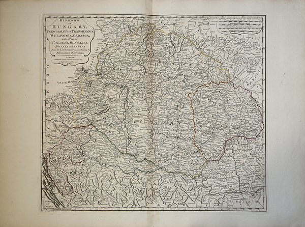
Kingdom of Hungary, Principality of Transilvania, Sclavonia, Croatia, with a Part of Valakla, Bulgaria, Bosnia and Servia fr
Kingdom of Hungary, Principality of Transilvania, Sclavonia, Croatia, with a Part of Valakla, Bulgaria, Bosnia and Servia fr
Mode de Paiement
- PayPal
- Carte bancaire
- Virement bancaire
- Pubblica amministrazione
- Carta del Docente
Détails
- Année
- 1794
- Lieu d'édition
- Londra
- Format
- 550 X 482
- Graveurs
- LAURIE & WHITTLE
Description
Una rara e precisa mappa del 1794 del Regno d'Ungheria di Laurie e Whittle. Sono inclusi il Regno di Ungheria e gli stati circostanti, tra cui la Transilvania (l'odierna Romania), la Bulgaria, la Bosnia, la Croazia, la Serbia. Numerosi dettagli tra cui strade, città, castelli, monasteri, foreste, fiumi e montagne. In alto a sinistra un cartiglio con il titolo appare.Mappa tratta dal "Kitchin's General Atlas, describing the Whole Universe" di Thomas Kitchin, una raccolta contenente alcune tra le mappe più accurate esistenti, realizzate con la massima precisione, e integrata dalla precedente edizione di D'Anville e Robert con i lavori di molti altri eminenti geografi. L'atlante, pubblicato Laurie & Whittle a Londra nel 1797, raccoglie 62 incisioni, che comprendono 37 mappe.Acquaforte, coloritura coeva dei contorni, in ottimo stato di conservazione. An rare and attractive 1794 map of the Kingdom of Hungary by Laurie and Whittle. Covers the Kingdom of Hungary and its surrounding states, including Transylvania (modern day Romania), Bulgaria, Bosnia, Croatia, Serbia. Offers an extraordinary level of detail throughout, noting post roads, towns, castles, monasteries, forests, swamps, rivers, cities and mountains. A title cartouche appears in the upper let quadrant. Published by Laurie and Whittle as plate no. 23 in the 1797 edition of Thomas Kitchin's General Atlas.Map taken from "Kitchin's General Atlas, describing the Whole Universe" by Thomas Kitchin: being a complete collection of the most approved maps extant; corrected with the greatest care, and augmented from the last edition of D'Anville and Robert with many improvements by other eminent geographers, engraved on Sixty-Two plates, comprising Thirty Seven maps., Laurie & Whittle, London, 1797.Etching with original outline colour, very good condition. Cfr.