L'Italie divisée en ses principaux Estats, Royaumes et Republiques…
L'Italie divisée en ses principaux Estats, Royaumes et Republiques… | Gravures | JAILLOT Alexis Hubert

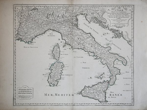
L'Italie divisée en ses principaux Estats, Royaumes et Republiques…
L'Italie divisée en ses principaux Estats, Royaumes et Republiques… | Gravures | JAILLOT Alexis Hubert
Mode de Paiement
- PayPal
- Carte bancaire
- Virement bancaire
- Pubblica amministrazione
- Carta del Docente
Détails
- Année
- 1718
- Lieu d'édition
- Parigi
- Format
- 620 X 530
- Graveurs
- JAILLOT Alexis Hubert
- Langues
- Italien
Description
Carta postale di Alexis Hubert Jaillot, disegnata sul modello cartografico di Nicolas Sanson e sulla carta postale della penisola di Giacomo Cantelli da Vignola. Si tratta di una rara carta geografica interessante per la visualizzazione degli itinerari postali raffigurati da regolari puntini corrispondenti ad un quarto di lega. Il titolo in alto a destra e la legenda delle distanze in basso a sinistra. Si legge: ' "L'Italie divisée en ses principaux Estats, Royaumes, et Republiques ou sont exactement remarquées toutes les routes des postes suivant qu'elles sont presentement etablies". Alexis Hubert Jaillot nacque verso il 1632 ad Avignon-lès-Saint-Claude. Dall’infanzia Jaillot aveva mostrato un buon talento per l’arte e il disegno e da suo fratello Pierre-Simón aveva imparato la scultura. Durante il conflitto franco-spagnolo la loro città natale fu devastata, e così i due fratelli si trasferirono a Parigi nel 1657. Lì acquisirono presto una certa reputazione e il titolo di “Sculpteur du Roy”. Nel 1665, Jaillot si sposò con Jeanne Berey, figlia di Nicolas I Berey, celebre tipografo parigino. La fortuna di Jaillot fu di entrare nel mercato cartografico in un momento particolarmente favorevole. All’inizio del 1668, sotto Luigi XIV, per la Francia iniziò un periodo particolarmente fecondo, come conseguenza della costante espansione territoriale c’era una grande richiesta di mappe che rappresentassero le conquiste francesi e le nuove frontiere. In seguito, Jaillot si associò con i figli di Nicolas Sanson, e fu in grado di commercializzare nuove carte con il prestigioso nome Sanson. Il suo atlante del 1681, l’Atlas Nouveau, divenne un tale successo commerciale che fu copiato illegalmente da altri editori. Jaillot non può essere annoverato tra i cartografi dell’epoca come i Sanson e Duval, fu però un abile incisore che seppe intelligentemente sfruttare le risorse che aveva ereditato, facendone opere mirabili. La sua fama crebbe al punto che il 20 luglio 1686 fu nominato “Géographe du Roy” e gli fu assegnata una cospicua pensione annuale; il titolo gli consentì di difendersi dai numerosi contraffattori. Una delle sue opere più belle fu Le Neptune François, o Atlas Nouveau des Cartes Marine. Dall’inizio del diciottesimo secolo la sua produzione di carte diminuì: erano richieste mappe sempre più aggiornate che non era in grado di offrire. D’altronde, i concorrenti più giovani erano geografi del calibro di Guillaume Delisle. Jaillot (m. 1712) cedette, quindi, l’azienda a suo figlio Bernard Jean-Hyacinthe. Acquaforte con coloritura coeva dei contorni, tracce di piega centrale, per il resto in ottimo stato di conservazione. Postal map by Alexis Hubert Jaillot, drawn on the cartographic model of Nicolas Sanson and Giacomo Cantelli. This is a rare map interesting for its display of postal routes depicted by regular dots corresponding to a quarter league. The title in the upper right and the legend of distances in the lower left. It reads, "L'Italie divisée en ses principaux Estats, Royaumes, et Republiques ou sont exactement remarquées toutes les routes des postes suivant qu'elles sont presentement etablies." On the death of Nicolas II, Alexis Hubert Jaillot took over as head of the printing house Berey. This skilled businessman was born around 1632 in Avignon-lès-Saint-Claude. Since childhood Jaillot had shown a good talent for art and drawing and had learned sculpture from his brother Pierre-Simón. During the Franco-Spanish conflict their hometown was devastated, and so the two brothers moved to Paris in 1657. There they soon acquired a certain reputation and the title of "Sculpteur du Roy". In 1665, Jaillot married with Jeanne Berey, daughter of Nicolas I Berey. Jaillot's fortune was to enter the cartographic market at a particularly favorable time. At the beginning of 1668, under Louis XIV, a particularly fruitful period began for France, as a consequence of the constant territorial expansion there was a great demand for maps that represented French conquests and new frontiers. Later, Jaillot joined forces with the sons of Nicolas Sanson, and was able to market new maps with the prestigious Sanson name. His Atlas of 1681, the "Atlas Nouveau", became such a commercial success that it was illegally copied by other publishers. Jaillot cannot be counted among the cartographers of the time such as the Sansons and Duval, but he was a skilled engraver who was able to intelligently exploit the resources he had inherited, making them wonderful works. His fame grew to the point that on 20 July 1686 he was named "Géographe du Roy" and was given a large annual pension; the title allowed him to defend himself against numerous counterfeiters. One of his most beautiful works was "Le Neptune François, or Atlas Nouveau des Cartes Marine". From the beginning of the eighteenth century its map production decreased: more and more updated maps were required which it was not able to offer; Jaillot (d. 1712) ceded, therefore, the company to his son Bernard Jean-Hyacinthe. Copperplate engraving, magnificent contemporary coloring with retouching, trace of central fold, overall in very good condition. Cfr. Borri, L'Italia nelle antiche carte dal medioevo all'Unità Nazionale, scheda 203.
