L'Italie…
Gravures
ELWE Jan Barend
1792
L'Italie…
Gravures
ELWE Jan Barend
1792
500,00 €
(Roma,
Italie)
Mode de Paiement
- PayPal
- Carte bancaire
- Virement bancaire
- Pubblica amministrazione
- Carta del Docente
Détails
- Année
- 1792
- Lieu d'édition
- Amsterdam
- Format
- 570 X 480
- Graveurs
- ELWE Jan Barend
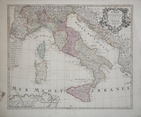
Description
Grande carta geografica d'Italia, che si estende a parte della Francia e dei Balcani. Il lavoro è basato sulla geografia di De L'Isle e sulle osservazioni dell'astronomo Riccioli. La mappa è dettagliata e presenta un decorativo cartiglio per il titolo. Incisione in rame, coloritura coeva, in perfette condizioni. A fine large map of all of Italy, including Sicily, Sardinia and Corsica, the surrounding parts of France and the Balkans. It is based on the geography of Guillaume Delisle and the observations of the astronomer Riccioli. The map is filled with detail and decorated with an ornate title cartouche. Copper engraving in good conditions. Cfr.