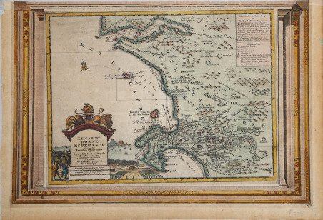
Le Cap de Bonne Esperance
Le Cap de Bonne Esperance | Gravures | VANDER AA Pieter


Le Cap de Bonne Esperance
Le Cap de Bonne Esperance | Gravures | VANDER AA Pieter
Mode de Paiement
- PayPal
- Carte bancaire
- Virement bancaire
- Pubblica amministrazione
- Carta del Docente
Détails
- Année
- 1713
- Lieu d'édition
- Leyden
- Format
- 390 X 265
- Graveurs
- VANDER AA Pieter
- Description
- O. I. Norwich, "Norwich's Maps of Africa", map 212.
Description
Piccola carta, estremamente dettagliata, del Capo da Saldanha a False Bay. Il magnifico cartiglio in basso a sinistra mostra una veduta di Table Bay sullo sfondo e il giardino del Governatore sulla destra. La carta è racchiusa in una cornice decorativa. Era parte della "Galerie Agreable du Monde", il famoso atlante di Vander Aa, completato nel 1729 e consistente in più di 3000 mappe. Incisione in rame con coloritura d’epoca successiva, in buone condizioni. This is a small detailed map of the Cape from Saldanha to False Bay. The attractive cartouche on lower left shows a view of Table Bay in the background, and the Governor’s garden on the right. The map is sourranded by a decorative engraved frame; included in the Galerie Agreable du Monde, the well-known atlas by Vander Aa, completed in 1729 and containing over 3000 maps. Copperplate with later hand colour, in good condition. Cfr. O. I. Norwich, "Norwich's Maps of Africa", map 212.
