Le Colonie Unite dell’America Settentr.le di nuova projezione.
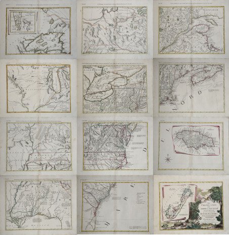
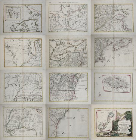
Le Colonie Unite dell’America Settentr.le di nuova projezione.
Mode de Paiement
- PayPal
- Carte bancaire
- Virement bancaire
- Pubblica amministrazione
- Carta del Docente
Détails
- Année
- 1778
- Lieu d'édition
- Venezia
- Format
- 1280 X 1300
- Graveurs
- ZATTA Antonio
- Description
- Sabin 68109; Stephenson, A la Carte, p. 113; cf P 650, 651. Map Forum 1, p. 58.
Description
Carta geografica murale, composta da 12 fogli ancora da unire, tratta dall'Atlante Novissimo dello Zatta, pubblicato a Venezia tra il 1779 ed il 1785. La carta è basata su quella di J. Mitchell che venne usata per stabilire i confini delle colonie nel trattato di pace del 1783 di Parigi, a conclusione della Guerra di Indipendenza. La carta divenne quindi la prima mappa ufficiale degli Stati Uniti. Quella dello Zatta rappresenta la prima edizione italiana di questa leggendaria carta, realizzata nel classico stile settecentesco veneziano, includendo un cartiglio molto decorativo contenente la carta delle Bermuda. Tuttavia la carta dello Zatta presenta delle significative varianti rispetto al suo prototipo, includendo maggiori informazioni geografiche, dedotte da altre fonti cartografiche. Per esempio la Virginia deriva dalla carta di Fry e Jefferson del 1753, mentre sono indicate informazioni relative alla guerra d’indipendenza nei dintorni di Saratoga, Philadelphia e Charleston. Da ricordare inoltre che questa rappresenta una delle prime carte ad assegnare alle colonie britanniche in rivolta l’appellativo di “Colonie unite”. Incisione in rame, coloritura coeva dei contorni, 12 fogli, in eccellente stato di conservazione. Carta geografica tratta dall’Atlante novissimo, illustrato ed accresciuto sulle osservazioni e scoperte fatte dai più celebri e più recenti geografi. Stampato in quattro volumi da Antonio Zatta tra il 1779 ed il 1785. Atlante fra i più belli e completi mai pubblicati in Italia nel XVIII secolo, l'opera più famosa dello Zatta. L’Atlante Novissimo, come si specifica anche nel titolo, è “accresciuto sulle osservazioni scoperte fatte dai più celebri e più recenti geografi”. Tra le novità più significative vi è la comparsa delle nuove isole scoperte nell'Oceano Pacifico da James Cook e la prima carta italiana della Nuova Zelanda. Le illustrazioni furono ' ideate e disegnate dai suoi collaboratori Giovanni Marco Pitteri, Anton Friedrich Busching, Pietro Antonio Novelli ed incise da Giuliano Zuliani. Il primo tomo dell’atlante è introdotto da un breve saggio di geografia generale dove l’autore definisce in modo sintetico e preciso gli elementi che compongono i reticoli eclittico ed equatoriale usati nelle tavole. Interessante la sezione dove si sofferma ' a descrivere il fenomeno della precessione degli equinozi e quello della variazione ciclica dell'obliquità dell'eclittica. Acquaforte, stampata su carta vergata coeva, coloritura coeva dei contorni, in buone condizioni. Geographic wall map, made of 12 sheets yet to be joined together. Taken from Zatta’s Atlante Novissimo published in Venice between 1779 and 1785. The map is based on J. Mitchell’s, which was used to establish the borders of the colonies during the peace treaty of Paris in 1783, after the Independence War, becoming henceforth the first, official map of the United States. Zatta’s map is the first, Italian edition of this legendary map; it has been realized in the characteristic eighteenth-century Venetian style, including also a cartouche depicting the map of the Bermuda Islands. Nevertheless, the map of Zatta differs quite a lot from its prototype for it shows many geographic details which were inferred from other cartographic sources. For instance, the State of Virginia derives from the 1753 map of Fry and Jefferson, while around the cities of Saratoga, Philadelphia and Charleston there are some information about the independence war. Noteworthy is also the fact that this is one of the first maps to define the British colonies the “United Colonies”. Map from the Atlante novissimo, illustrato ed accresciuto sulle osservazioni e scoperte fatte dai più celebri e più recenti geografi. Printed in four volumes by Antonio Zatta between 1779 and 1785. ' Atlas among the most beautiful and complete ever published in Italy in the eighteenth century, the most famous work of Zatta. The Atlante Novissimo, as also specified in the title, is “increased on the observations made by the most famous and most recent geographers”. Among the most significant innovations there is the appearance of the new islands discovered in the Pacific Ocean by James Cook and the first Italian map of New Zealand. The illustrations were designed and drawn by his collaborators Giovanni Marco Pitteri, Anton Friedrich Busching, Pietro Antonio Novelli and engraved by Giuliano Zuliani. The first volume of the atlas is introduced by a brief essay of general geography where the author defines in a concise and precise way the elements that make up the ecliptic and equatorial grids used in the tables. Interesting is the section where he pauses to describe the phenomenon of precession of the equinoxes and the cyclical variation of the obliquity of the ecliptic. Etching, printed on contemporary laid paper, contemporary outline coloring, in good condition. Cfr. Sabin 68109; Stephenson, A la Carte, p. 113; cf P 650, 651. Map Forum 1, p. 58.