Le Colonie Unite delle Americhe Settentr.le di Nuova Projezione
Le Colonie Unite delle Americhe Settentr.le di Nuova Projezione | Gravures | ZATTA Antonio


Le Colonie Unite delle Americhe Settentr.le di Nuova Projezione
Le Colonie Unite delle Americhe Settentr.le di Nuova Projezione | Gravures | ZATTA Antonio
Mode de Paiement
- PayPal
- Carte bancaire
- Virement bancaire
- Pubblica amministrazione
- Carta del Docente
Détails
- Année
- 1778
- Lieu d'édition
- Venezia
- Format
- 445 X 340
- Graveurs
- ZATTA Antonio
Description
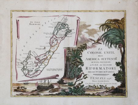
Frontespizio di una carta degli Stati Uniti in dodici fogli, con le Bermuda raffigurate in un cartiglio trompe-l'oeil. Le Bermuda presentano un interessante errore cartografico. La prima mappa autorevole delle Bermuda fu compilata da Norwood nel 1622 e pubblicata da John Speed nel 1627. Dietro la mappa principale Norwood sovrappose le coste della Nuova Inghilterra e della Virginia per mostrare la posizione relativa delle Bermuda. Sebbene Zatta abbia eliminato questa terraferma dalla sua mappa, ha mantenuto la piccola Bermuda, scambiandola per un'altra isola della catena. Ciò conferma che la fonte di Zatta per questa mappa risale a più di un secolo fa. Carta geografica tratta dall’Atlante novissimo, illustrato ed accresciuto sulle osservazioni e scoperte fatte dai più celebri e più recenti geografi. ' Stampato in quattro volumi da Antonio Zatta tra il 1779 ed il 1785. Atlante fra i più belli e completi mai pubblicati in Italia nel XVIII secolo, l'opera più famosa dello Zatta.L’Atlante Novissimo, come si specifica anche nel titolo, è “accresciuto sulle osservazioni scoperte fatte dai più celebri e più recenti geografi”. Tra le novità più significative vi è la comparsa delle nuove isole scoperte nell'Oceano Pacifico da James Cook e la prima carta italiana della Nuova Zelanda. Le illustrazioni furono ' ideate e disegnate dai suoi collaboratori Giovanni Marco Pitteri, Anton Friedrich Busching, Pietro Antonio Novelli ed incise da Giuliano Zuliani. Il primo tomo dell’atlante è introdotto da un breve saggio di geografia generale dove l’autore definisce in modo sintetico e preciso gli elementi che compongono i reticoli eclittico ed equatoriale usati nelle tavole. Interessante la sezione dove si sofferma ' a descrivere il fenomeno della precessione degli equinozi e quello della variazione ciclica dell'obliquità dell'eclittica. Acquaforte, stampata su carta vergata coeva, coloritura coeva dei contorni, in buone condizioni. Bibliografia PALMER, ' Printed maps of Bermuda, p.26, plate xxxi. The title-sheet of a twelve-sheet map of the United States, with Bermuda shown on a trompe-l'oeil scroll. Bermuda has an interesting cartographic error. The first authoritative map of Bermuda was compiled by Norwood in 1622 and published by John Speed in 1627. Behind the main map Norwood superimposed the coastline of New England and Virginia to show the relative position of Bermuda. Although Zatta has dropped this mainland from his map he has retained the small Bermuda, mistaking it for another island in the chain. This confirms that Zatta's source for this map was over a century old. Map from the ' Atlante novissimo, illustrato ed accresciuto sulle osservazioni e scoperte fatte dai più celebri e più recenti geografi. Printed in four volumes by Antonio Zatta between 1779 and 1785. ' Atlas among the most beautiful and complete ever published in Italy in the eighteenth century, the most famous work of Zatta. The ' Atlante Novissimo, as also specified in the title, is “increased on the observations made by the most famous and most recent geographers”. Among the most significant innovations there is the appearance of the new islands discovered in the Pacific Ocean by James Cook and the first Italian map of New Zealand. The illustrations were designed and drawn by his collaborators Giovanni Marco Pitteri, Anton Friedrich Busching, Pietro Antonio Novelli and engraved by Giuliano Zuliani. The first volume of the atlas is introduced by a brief essay of general geography where the author defines in a concise and precise way the elements that make up the ecliptic and equatorial grids used in the tables. Interesting is the section where he pauses to describe the phenomenon of precession of the equinoxes and the cyclical variation of the obliquity of the ecliptic. Etching, printed on contemporary laid paper, contemporary outline coloring, in good condition. Bibliografia PALMER: Printed maps of Bermuda, p.26, plate xxxi. Cfr.
