Le Royaume de Boheme divisée en ses douze cercles Carte Rediute Sur celle de 25 Feuilles par I.C. Muller Capit. et…
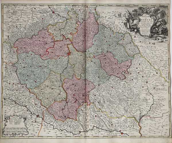
Le Royaume de Boheme divisée en ses douze cercles Carte Rediute Sur celle de 25 Feuilles par I.C. Muller Capit. et…
Mode de Paiement
- PayPal
- Carte bancaire
- Virement bancaire
- Pubblica amministrazione
- Carta del Docente
Détails
- Année
- 1745
- Lieu d'édition
- Amsterdam
- Format
- 630 X 510
- Graveurs
- SCHENK Pieter
Description
Mappa fine e dettagliata che mostra il Regno di Boemia secondo la fonte cartografica di Johann Christian Müller con le vicine Baviera, Sassonia, Austria e Slesia. Nell'angolo in alto a destra una bella incisione allegorica raffigurante una scena di guerra e nell'angolo in basso a sinistra un cartiglio contentente una legenda con simboli e spiegazioni. I dodici cerchi del regno di Boemia sono evidenziati da zone colorate. Sono presenti molti nomi di luoghi, città e villaggi, castelli, fiumi, montagne, laghi. Sono mostrate anche le strade tra le città principali.Esemplare tratta dall'Atlas Novus di Reiner & Joshua Ottes, che acquistarono i rami della tipografia Schenk. Copper engraving, hand colored. A fine and detailled engraved map showing the kingdom of Bohemia after the cartographic source by Johann Christian Müller with the neighboring parts of Bavaria, Saxonia, Austria and Silesia.In the upper right corner is a fine allegoric engraving depicting a war scene and in the lower left corner a table with explanations. The twelve circles of the kingdom of Bohemia are detailled shown in their borders in contemporary body hand color. With many engraved place names of cities and villages, castles, rivers, mountains, lakes. A fine example from the Atlas Novus by. Reiner & Joshua Ottes. Cfr.