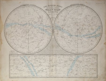
Les Étoiles Fixes divisées en Constellations Boréales et Australes
Les Étoiles Fixes divisées en Constellations Boréales et Australes | Gravures | Andriveau-Goujon Eugène
Les Étoiles Fixes divisées en Constellations Boréales et Australes
Les Étoiles Fixes divisées en Constellations Boréales et Australes | Gravures | Andriveau-Goujon Eugène
Mode de Paiement
- PayPal
- Carte bancaire
- Virement bancaire
- Pubblica amministrazione
- Carta del Docente
Détails
- Année
- 1854
- Lieu d'édition
- Parigi
- Format
- 660 X 500
- Graveurs
- Andriveau-Goujon Eugène
- Thème
- Carte Celesti
Description
Carta celeste a doppio emisfero con evidenza della fascia equatoriale; la prima delle tavole contenute nell'atlante geografico-storico di grande formato del Geografo-Editore J. Andriveau-Goujon, edito a Parigi a metà ' dell'Ottocento. L'Atlas de Choix, ou recueil des meilleures cartes de Geographie ancienne et moderne è un'opera grafica di tipo enciclopedico composta da sessanta tavole, disegnate e scritte da diversi autori sotto la direzione dell'editore. Comprende cinque tavole di contenuto astronomico seguite da una dozzina di carte storiche e da quelle geografiche che rappresentano il gruppo più numeroso. Dopo i due planisferi abbiamo l'Europa ed i suoi stati che, in particolare la Francia, sono riprodotti in modo ampio e dettagliato. L'ultimo terzo del volume è dedicato agli stati degli altri continenti. Chiude l'opera una bellissima carta di formato extra dedicata ai fiumi e alle montagne del globo. Andriveau-Goujon, tra i suoi contemporanei, fu l’unico che incluse un cospicuo gruppo di carte celesti nel suo atlante generale. La raccolta cartografica di Eugène Andriveau-Goujon venne pubblicata per la prima volta nel 1848 circa, con il titolo di ' Atlas classique et universel de geographie ancienne et moderne, contenant les decouvertes et les divisions les plus nouvelles dans les cinq parties du monde pour servir a la lecture des voyages, des ouvrages historiques et des meilleurs traites de geographie. Publie par J. Andriveau-Goujon. Adopte par le Ministre de la Guerre pour les bibliotheques regimentaires. Successive ristampe contengono il corpus originale di carte e una cospicua addenda. Eugène Andriveau-Goujon (1832 - 1897) fu un editore di mappe e cartografo attivo nella Parigi del XIX secolo. L'azienda fu creata nel 1825 quando Eugène Andriveau sposò la figlia dell'editore di mappe Jean Goujon, dando così vita ad Andriveau-Goujon. Le mappe di Andriveau-Goujon sono spesso confuse da identificare in quanto possono essere alternativamente denominate J. Goujon, J. Andriveau, J. Andriveau-Goujon, E. Andriveau-Goujon o semplicemente Andriveau-Goujon. Ciò si riferisce alle molteplici generazioni della dinastia Andriveau-Goujon e alla tendenza a ripubblicare materiale più vecchio senza aggiornare l'imprint. Le prime mappe con l'imprint Andriveau-Goujon furono pubblicate da Jean Andriveau-Goujon. Egli passò l'attività al figlio Gilbert-Gabriel Andriveau-Goujon, che nel 1858 passò al figlio Eugène Andriveau-Goujon, sotto la cui gestione l'azienda fu più prolifica. Andriveau-Goujon pubblicò numerose mappe tascabili e atlanti di pregio per tutto il XIX secolo e collaborò spesso con altri importanti cartografi francesi dell'epoca, come Brue e Levasseur. Lo stock della ditta fu acquisito da M. Barrère nel 1892. Litografia con colori originali, leggera gora d'acqua ai lati, per il resto in buono stato di conservazione. Double hemisphere celestial map with evidence of the equatorial belt; the first of the plates contained in the large-format geographic-historical atlas by Geographer-Editor J. Andriveau-Goujon, published in Paris in the mid-19th century. L'Atlas de Choix, ou recueil des meilleures cartes de Geographie ancienne et moderne is an encyclopedic graphic work consisting of sixty plates, drawn and written by different authors under the direction of the publisher. It includes five plates of astronomical content followed by a dozen historical maps and geographical maps, which represent the largest group. After the two planispheres we have Europe and its states, which, particularly France, are reproduced in ample detail. The last third of the volume is devoted to the states of the other continents. Closing the work is a beautiful extra-format map devoted to the rivers and mountains of the globe. Andriveau-Goujon, among his contemporaries, was the only one who included a conspicuous group of celestial charts in his general atlas. Eugène Andriveau-Goujon's cartographic collection was first published in about 1848 under the title ' Atlas classique et universel de geographie ancienne et moderne, contenant les decouvertes et les divisions les plus nouvelles dans les cinq parties du monde pour servir a la lecture des voyages, des ouvrages historiques et des meilleurs traites de geographie. Publie par J. Andriveau-Goujon. Adopte par le Ministre de la Guerre pour les bibliotheques regimentaires. Subsequent reprints contain the original body of maps and a substantial addendum. Eugène Andriveau-Goujon (1832 - 1897) was a map publisher and cartographer active in 19th century Paris. The firm was created in 1825 when Eugène Andriveau married the daughter of map publisher Jean Goujon - thus creating Andriveau-Goujon. Maps by Andriveau-Goujon are often confusing to identify as they can be alternately singed J. Goujon, J. Andriveau, J. Andriveau-Goujon, E. Andriveau-Goujon, or simply Andriveau-Goujon. This refers to the multiple generations of the Andriveau-Goujon dynasty and the tendency to republish older material without updating the imprint. The earliest maps to have the Andriveau-Goujon imprint were released by Jean Andriveau-Goujon. He passed the business to his son Gilbert-Gabriel Andriveau-Goujon, who in 1858 passed to his son, Eugène Andriveau-Goujon, under whose management the firm was most prolific. Andriveau-Goujon published numerous fine pocket maps and atlases throughout the 19th century and often worked with other prominent French cartographers of the time such as Brue and Levasseur. The firm's stock was acquired by M. Barrère in 1892. Litograph with original colour, light waterstain at the left and righ edges, othewise good condition. Cfr.
