Magni Mogolis Imperium de Novo Correcturm et Divisum per F. De Witt

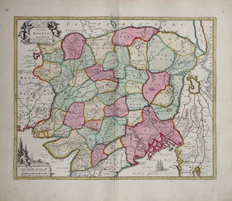
Magni Mogolis Imperium de Novo Correcturm et Divisum per F. De Witt
Mode de Paiement
- PayPal
- Carte bancaire
- Virement bancaire
- Pubblica amministrazione
- Carta del Docente
Détails
- Année
- 1740
- Lieu d'édition
- Amsterdam
- Format
- 520 X 420
- Graveurs
- WIT Frederick de
- Description
- Koeman, Atlantes Neerlandici, part III, p. 201, map 118, Cole, India within the Ganges, entry 40, 1.1.2.
Description
Bella mappa raffigurante la parte settentrionale di India, Afghanistan, Pakistan, Bangladesh, Nepal e Tibet. Impreziosita da un cartiglio con il titolo e da un secondo con le scale di misurazione.Originariamente pubblicata da Frederick de Wit dopo il 1688 e poi ripubblicata da Covens & Mortier.Bellissimo esemplare con coloritura coeva. An attractive map depicting the northern part of India, Afghanistan, Pakistan, Bangladesj, Nepal and Tibet. Embellished with a title-cartouche and a cartouche with scales.Originally published by Frederick de Wit after 1688, re-issued by Covens & Mortier.A fine example with contemporary colour. Cfr. Koeman, Atlantes Neerlandici, part III, p. 201, map 118, Cole, India within the Ganges, entry 40, 1.1.2.