Mappa Aestivarum Insularum, alias Barmudas
Mappa Aestivarum Insularum, alias Barmudas | Gravures | JANSSONIUS Johannes


Mappa Aestivarum Insularum, alias Barmudas
Mappa Aestivarum Insularum, alias Barmudas | Gravures | JANSSONIUS Johannes
Mode de Paiement
- PayPal
- Carte bancaire
- Virement bancaire
- Pubblica amministrazione
- Carta del Docente
Détails
- Année
- 1640
- Lieu d'édition
- Amsterdam
- Format
- 520 X 400
- Graveurs
- JANSSONIUS Johannes
- Description
- Palmer/Tooley, The mapping of Bermuda, plate XI.
Description
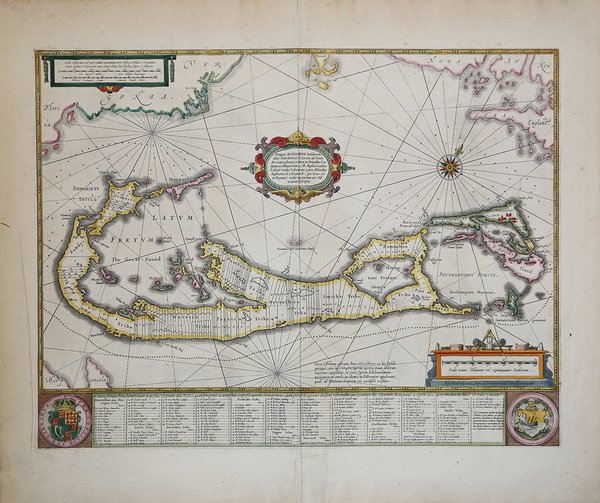
Questa magnifica mappa si basa sulla relazione di John Norwood, della Bermuda Company, del 1618. Il territorio è diviso nelle originarie tribù, e nella tabella sono riportati i nomi dei primi coloni, con la relativa parte assegnata. L'isola fu scoperta nel 1515 dallo spagnolo Juan de Bernudez, che le diede il nome. Ma fu solo a partire dal naufragio del 1609 della "Sea Venture", guidata da Sir George Sommers, che l'isola venne colonizzata dagli inglesi, per diventare colonia britannica nel 1684. In omaggio all'ammiraglio, gli inglesi chiamarono l'isola Sommers o Summers Island, da qui il titolo latino di "Mappa Aestivarum Insularum". Di ulteriore interesse, la raffigurazione, nella superiore della mappa, della Virginia e di New England, mentre in basso, a sinistra, si vede la punta di Hispaniola. Una delle più più accurate e affascinanti mappe dell'epoca. Johannes Janssonius, figlio dell'editore di Arnhem Jan Janssen, sposò Elisabeth Hondius, figlia di Jodocus Hondius, ad Amsterdam nel 1612. Dopo il suo matrimonio, si stabilì in questa città come libraio ed editore di materiale cartografico. Nel 1618 si stabilì ad Amsterdam accanto alla libreria di Willem Jansz. Blaeu, entrando in una seria competizione. Le sue attività non riguardavano solo la pubblicazione di atlanti e libri, ma anche di mappe singole e un vasto commercio di libri con filiali a Francoforte, Danzica, Stoccolma, Copenaghen, Berlino, Koningsbergen, Ginevra e Lione. Nel 1631 iniziò a pubblicare atlanti insieme a Henricus Hondius. Nei primi anni 1640 Henricus Hondius lasciò l'attività di pubblicazione di atlanti completamente a Janssonius. La concorrenza con Joan Blaeu, figlio e successore di Willem, nella produzione di atlanti spinse Janssonius ad ampliare il suo Atlas Novus finalmente in un'opera di sei volumi, in cui furono inseriti un atlante marino e un atlante del Vecchio Mondo. Dopo la morte di Joannes Janssonius, il negozio e la casa editrice furono continuati dagli eredi sotto la direzione di Johannes van Waesbergen (c. 1616-1681), genero di Joannes Janssonius. Le matrici degli atlanti di Janssonius furono in seguito vendute a Schenk e Valck. Incisione in rame, coloritura coeva dei confini, in ottime condizioni. The map shows the island divided into tribes and lots, and below the map itself appear the coats of arms of Bermuda and England and the names of the first proprietors and the number of shares assigned each. A most attractive variant on the Norwood survey map. The ‘Sea Venture’ under Sir George Somers was wrecked off Bermuda in 1609 and the surviving Englishmen divided the island into Tribes (later Parishes) and Shares, which are individually listed with their owners at the foot of the map. The map's Latin title, Mappa Aestivarum Insularum, means Summer (or Somers) Island for its first leader. Shortly afterwards the Bermudas were granted to the Virginia Company, hence various references to the Company on the map including the distance to the Roanoke Colony in Virginia. The miniature map with its own scale, top left, shows the island’s position relative to the Virginian coast. Jansson derived his map from Richard Norwood’s survey which was carried out in 1622 and published by John Speed in 1627. It remains one of the most accurate and decorative maps of the period. Johannes Janssonius (Arnhem, 1588-1664), son of the Arnhem publisher Jan Janssen, married Elisabeth Hondius, daughter of Jodocus Hondius, in Amsterdam in 1612. After his marriage, he settled down in this town as a bookseller and publisher of cartographic material. In 1618 he established himself in Amsterdam next door to Blaeu’s book shop. He entered into serious competition with Willem Jansz. Blaeu. His activities not only concerned the publication of atlases and books, but also of single maps and an extensive book trade with branches in Frankfurt, Danzig, Stockholm, Copenhagen, Berlin, Koningsbergen, Geneva, and Lyon. In 1631 he began publishing atlases together with Henricus Hondius. In the early 1640s Henricus Hondius left the atlas publishing business completely to Janssonius. Competition with Joan Blaeu, Willem’s son and successor, in atlas production prompted Janssonius to enlarge his Atlas Novus finally into a work of six volumes, into which a sea atlas and an atlas of the Old World were inserted. After the death of Joannes Janssonius, the shop and publishing firm were continued by the heirs under the direction of Johannes van Waesbergen (c. 1616-1681), son-in-law of Joannes Janssonius. The copperplates from Janssonius’s atlases were afterwards sold to Schenk and Valck. Copperplate, original outline colour, in good condition. Cfr. Palmer/Tooley, The mapping of Bermuda, plate XI.
