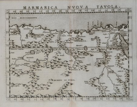
Marmarica Nuova Tavola
Marmarica Nuova Tavola | Gravures | RUSCELLI Girolamo

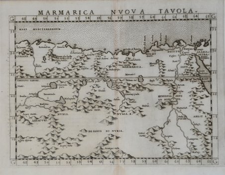
Marmarica Nuova Tavola
Marmarica Nuova Tavola | Gravures | RUSCELLI Girolamo
Mode de Paiement
- PayPal
- Carte bancaire
- Virement bancaire
- Pubblica amministrazione
- Carta del Docente
Détails
- Année
- 1561
- Lieu d'édition
- Venezia
- Format
- 260 X 190
- Graveurs
- RUSCELLI Girolamo
Description
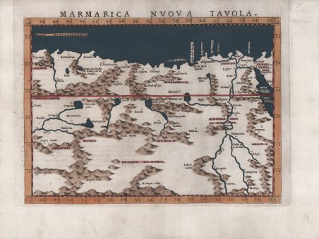
Mappa di Girolamo Ruscelli basata sull'opera di Tolomeo e copre una porzione dell'Africa settentrionale dalla penisola arabica a est fino a Cirene a ovest, antica città dell'Africa settentrionale fondata come colonia dorica nel VII secolo a.C., in quella che è ora il paese della Libia. La mappa raffigura città, sistemi fluviali e laghi, catene montuose e porzioni sia del Mar Rosso che del Mediterraneo. All'epoca in cui questa mappa fu disegnata per la prima volta, la regione faceva parte dell'Impero Ottomano sotto Solimano il Magnifico, noto agli Ottomani come il Legislatore, sotto il cui regno cadde la Libia nel 1551. ' Carta tratta dalla ' Geographia di Claudio Tolomeo, a cura di Girolamo Ruscelli, pubblicata in Venezia in più edizioni tra il 1561 ed il 1598. La carta è basata sulla “Geografia” di Giacomo Gastaldi (1548), che probabilmente disegnò personalmente anche queste mappe, che vennero incise dai fratelli Livio e Giulio Sanuto. La peculiarità di queste mappe è che sono incise due per lastra e successivamente tagliate; questo il motivo per cui il segno del rame appare solo in tre lati della mappa. Il testo del Ruscelli e le sue carte sono considerate come il miglior atlante moderno fino alla prima versione del ' Theatrum ' ' Orbis Terrarum ' di Abraham Ortelius (1570). Solo la loro larga diffusione ne impedisce una valutazione sostenuta nel mercato antiquario. L'opera infatti ebbe una prima stesura nel 1561, stampata da Vincenzo Valgrisi che ne curò anche la ristampa del 1562. Tre sono le edizioni firmate da Giordano Ziletti (due nel 1564 e una del 1574), mentre nel 1597 viene edita dai fratelli Calignani. Tutte queste edizioni contengono 64 tavole. Nel 1598 e 1599 vengono alla luce le due edizioni curate da Giuseppe Rosaccio e stampate dagli Eredi di Melchior Sessa. Queste ultime due edizioni comprendono 69 tavole; sono infatti aggiunte la carta del planisfero e dei continenti di Rosaccio. Acquaforte e bulino, finemente colorata a mano, in ottimo stato di conservazione. Ruscelli map based on the work of Ptolemy and covers a portion of northern Africa from the Arabian Peninsula in the east to Cyrene in the west, an ancient city in northern Africa which was founded as a Dorian colony in the seventh century B.C., in what is now the country of Libya. The map depicts cities, river systems and lakes, mountain ranges, and portions of both the Red Sea and the Mediterranean. At the time this map was first drawn, the region was part of the Ottoman Empire under Suleiman the Magnificent, known to the Ottomans as the Lawgiver, under whose reign Libya fell in 1551. Indeed, much of the northern portion of Africa which is featured here was controlled by the Ottomans for some time. Under Suleiman the Ottomans developed a great naval force which was headed by the famed Barbarossa, who built it to such an extent that there were more ships in the Ottoman fleet than in all the fleets of Western Europe combined. By the mid 16th ' century, the Ottomans were the dominant force in much of Europe, the Middle East, northern Africa and in the east of the continent as far south as the Horn of Africa. ' ' Map taken from ' Geographia di Claudio Tolomeo ' edited by Girolamo Ruscelli, published in Venice in several editions between 1561 and 1598. The maps is based on the ' Geografia ' by Giacomo Gastaldi (1548), who probably also personally drew these maps, which were engraved by the brothers Livio and Giulio Sanuto. The peculiarity of these maps is that they are engraved two for plate and subsequently cut; this is why the copper sign only appears on three sides of the map. Ruscelli's text and his maps are considered to be the best modern atlas up to the first version of Abraham Ortelius' ' Theatrum Orbis Terrarum ' (1570). Only their widespread diffusion prevents a sustained evaluation in the antiquarian market. In fact, the work had a first edition in 1561, printed by Vincenzo Valgrisi who also edited the 1562 reprint. There are three editions signed by Giordano Ziletti (two in 1564 and one in 1574), while in 1597 it was published by the Calignani brothers. All these editions contain 64 plates. In 1598 and 1599 the two editions edited by Giuseppe Rosaccio and printed by the heirs of Melchior Sessa came to light. These last two editions include 69 plates; in fact, Rosaccio's map of the planisphere and continents has been added. Etching and engraving with fine later hand colour, in good condition. Cfr.
