Nouvelle Carte De L'Allemagne avec des Tables des Branches de la Noblesse et les Lieux Les Plus Remarquables de Leurs Resida
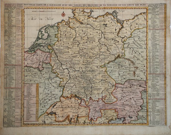

Nouvelle Carte De L'Allemagne avec des Tables des Branches de la Noblesse et les Lieux Les Plus Remarquables de Leurs Resida
Mode de Paiement
- PayPal
- Carte bancaire
- Virement bancaire
- Pubblica amministrazione
- Carta del Docente
Détails
- Année
- 1719
- Lieu d'édition
- Parigi
- Format
- 630 X 472
- Graveurs
- CHATELAIN Henri Abraham
Description
Mappa dettagliata dell'impero tedesco, tratta dal volume sette dell'"Atlas Historique" di Chatelain, pubblicato ad Amsterdam.La mappa è affiancata da due tabelle che identificano le principali città e regioni associate a ciascuna delle diverse dinastie. Questa bella mappa è un esempio importante tratto dal testo di Chatelain, soprattutto perché combina davvero tante informazioni e osservazioni geografiche, con delicate incisioni e una composizione non complicata. Henri Abraham Chatelain (1684 - 1743) era un pastore ugonotto di origini parigine. È meglio conosciuto come cartografo olandese e più specificamente per il suo contributo cartografico nell’Atlas Historique ' in sette volumi, pubblicato ad Amsterdam tra il 1705 e il 1720. Innovativo per il suo tempo, l'Atlas Historique ' combinava incisioni e opere d'arte con studi di geografia, storia, etnologia, araldica e cosmografia. Alcuni studiosi suggeriscono che l'Atlas Historique ' non fu compilato esclusivamente da Henri Chatelain, come si crede comunemente, ma piuttosto fu un'impresa familiare che coinvolse Henri, suo padre Zacharie e suo fratello, sempre Zacharie. Detailed map of the German Empire, from Chatelain's monumental 7 volume Atlas Historique, published by Chatelain in AmsterdamThe map is flanked by two tables identifying the principal towns and regions associated with each of the different dynasties. This fine map is a wonderful example from Chatelain’s important text. By combining a wealth of information and geographical observation, with delicate engraving and an uncomplicated composition. Henri Abraham Chatelain (1684 - 1743) was a Huguenot pastor of Parisian origins. He is best known as a Dutch cartographer and more specifically for his cartographic contribution in the seminal seven volume ' Atlas Historique, published in Amsterdam between 1705 and 1720. Innovative for its time, the ' Atlas Historique ' combined fine engraving and artwork with scholarly studies of geography, history, ethnology, heraldry, and cosmography. Some scholarship suggests that the ' Atlas Historique ' was not exclusively compiled by Henri Chatelain, as is commonly believed, but rather was a family enterprise involving Henri, his father Zacharie and his brother, also Zacharie. Cfr.