Nouvelle Carte Marine de la Partie d’Orient et d’Occident de la Mediterranée
Nouvelle Carte Marine de la Partie d’Orient et d’Occident de la Mediterranée
Mode de Paiement
- PayPal
- Carte bancaire
- Virement bancaire
- Pubblica amministrazione
- Carta del Docente
Détails
- Année
- 1700
- Lieu d'édition
- Amsterdam
- Format
- 1200 X 525
- Graveurs
- LOOTS Johannes
- Description
- S. Bifolco, "Mare Nostrum, Cartografia nautica a stampa del Mar Mediterraneo" (2020), pp. 162-163, tav. 70.
Description
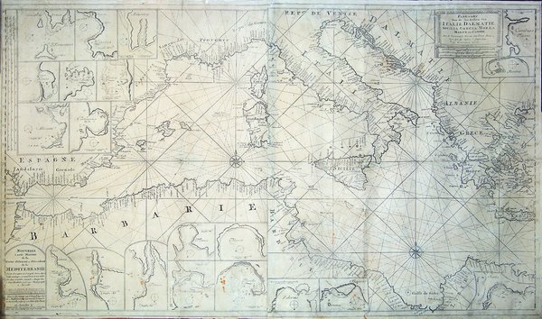
Nouvelle Carte Marine de la Partie d’Orient et d’Occident de la Mediterranée Avec la d’Escription des Principales Havres, Bayes, Rades, et emrages, en grand Point, le tout étables Par leur veritables Latitudes Marqué Par le Sieur Berthelot professeur D’Hydrographe à Marseille. Ce vendens che Iean Loots Marchant Librarie de Cartes et Autres Instruments de Marine pour les Ingenieurs et Canonniers, demeurant dans le Petit Rue de Pont Neuf à Amsterdam = Nieuwe Pas-kaart van ‘t Westelyckste deel der Middelantsche Zee met de Voor-naamste Havens alles gelegt op zyn Behoorlyke Breete tot Amsterdam by Ioannes Loots Boek Zeekart Verkooper en Graadboogmaaker inde Nieuwebrugsteeg inde Ionge Lootsman & Paskaart Van de Zee-kusten van Italie, Dalmatie, Sicilia, Grecia, Morea Malte en Candie Met de voornaamste Havens Int Groot Nooit voor dase Soo Gesien. ‘t Amsterdam by Ioannes Loots.Acquaforte e bulino, rispettivamente di dimensioni 605x525 mm (parte occidentale) e 600x530 mm (parte orientale). Buona prova, impressa su due fogli di carta vergata coeva, con sottili margini, alcuni restauri perfettamente eseguiti, nel complesso in buono stato di conservazione. Esemplare con tracce di usura, probabilmente utilizzato per la navigazione in mare. Rarissimo portolano del Mediterraneo di Johannes Loots. Doppio titolo, in francese e olandese, nel cartiglio in basso a sinistra del foglio di ponente; solo titolo olandese nel cartiglio in alto a destra del foglio di levante. L’imprint del Loots è riportato in entrambi i cartigli: tot Amsterdam by Ioannes Loots Boek Zeekart Verkooper en Graadboogmaaker inde Nieuwebrugsteeg inde Ionge Lootsman.Grande carta nautica del Mediterraneo, priva di data ma pubblicata tra il 1698 e il 1707. Si basa, come correttamente enunciato nel cartiglio con il titolo in francese, sulla carta pubblicata dall’idrografo François Berthelot a Marsiglia nel 1693. Rispetto alla tavola del Berthelot, vengono introdotti numerosi riquadri, contenenti altrettanti piani nautici. Nel foglio occidentale sono rappresentati i porti di: Formentera, Majorca, Minorca, Genova, La Spezia, Livorno, Alicante, Cartagine, Tangeri, Ceuta, Tunisi, Algeri, Taranto, e Tripoli. Nel foglio orientale troviamo quelli di Carabuso, Messina, Palermo, Trapani e Santa. Johannes Loots nacque ad Amsterdam nel 1665 circa. Le prime notizie lo danno come produttore di strumenti; intorno al 1693 si stabilì nel negozio in Nieuwebrugsteeg, con insegna “In de Jonge Lootman”. La scelta della strada non fu casuale; vivevano e lavoravano nella stessa via, infatti, Johannes van Keulen ed Hendrick Doncker, nel cui negozio Johannes Loots aveva svolto il suo apprendistato come produttore di strumenti matematici e nautici. Sebbene questa professione non lo qualificasse come venditore di libri e stampe, la corporazione dei librai, dopo qualche esitazione, lo accettò come membro nel maggio del 1693. L’attività di Loots come editore di carte è datata al primo aprile 1695: in un contratto notarile risalente a questa data, Loots fece un accodo con l’incisore Antoni de Winter per l’intaglio di un certo numero di carte nautiche da stampare in collaborazione. Si presume che queste carte siano poi state usate per il primo atlante nautico di Loots, il Het nieu en compleet Paskaart Boek van de Noord en Oost Zee, del 1697. Tuttavia, Antoni de Winter, non rispettando gli accordi, si associò con il perito agrario e matematico Claas de Vries con lo scopo di realizzare una guida nautica “con la proiezione di Mercatore e latitudine crescente”. Solo in seguito Loots venne coinvolto nel progetto e ricevette, il 2 luglio 1698, il privilegio per stampare un atlante nautico che, sebbene addirittura pubblicizzato nel Courster Amsterdamsche del 28 agosto 1698, non venne mai pubblicato. Durante il periodo 1698 – 1707, però, la tipografia produsse una cospicua quantità di mappe che venivano vendute in raccolte assemblate su ordinazione e senza un vero. Nouvelle Carte Marine de la Partie d’Orient et d’Occident de la Mediterranée Avec la d’Escription des Principales Havres, Bayes, Rades, et emrages, en grand Point, le tout étables Par leur veritables Latitudes Marqué Par le Sieur Berthelot professeur D’Hydrographe à Marseille. Ce vendens che Iean Loots Marchant Librarie de Cartes et Autres Instruments de Marine pour les Ingenieurs et Canonniers, demeurant dans le Petit Rue de Pont Neuf à Amsterdam = Nieuwe Pas-kaart van ‘t Westelyckste deel der Middelantsche Zee met de Voor-naamste Havens alles gelegt op zyn Behoorlyke Breete tot Amsterdam by Ioannes Loots Boek Zeekart Verkooper en Graadboogmaaker inde Nieuwebrugsteeg inde Ionge Lootsman & Paskaart Van de Zee-kusten van Italie, Dalmatie, Sicilia, Grecia, Morea Malte en Candie Met de voornaamste Havens Int Groot Nooit voor dase Soo Gesien. ‘t Amsterdam by Ioannes Loots.Etching and engraving, respectively 605x525 mm (western part) and 600x530 mm (eastern part).Good proof, printed on two sheets of contemporary laid paper, with thin margins, some perfectly executed restorations, overall in good condition. Example with traces of wear, probably due to use in navigation.Extremely rare Mediterranean portolan by Johannes Loots. Title in French and Dutch, in the cartouche, at lower left, in western part; only in Dutch in the cartouche at upper right in the eastern part. On both cartouche the imprint: tot Amsterdam by Ioannes Loots Boek Zeekart Verkooper en Graadboogmaaker inde Nieuwebrugsteeg inde Ionge Lootsman.It depicts the coastlines of large part of the Mediterranean Sea, from Gibraltar till the island of Creta, and also a small portion of the Atlantic in the approaches to Gibraltar. Very accurate description of the sea locations and, in the landside, detailed description of 20 important ports. In the lower left corner a cartouche in French: "Nouvelle Carte marine de la partie d'Orient et d'occident de la Mediterranee." by Berthelot, professor in Marseille.Only a few of Johannes Loots'sea charts have survived to modern times, mostly because they were used by mariners at sea. Johannes Loots (1665 - 1726) was active from 1693 until his death in 1726. Loots began his career by Hendrick Doncker. Several charts from this maker were offered separately.In 1707, Loots sold 100 charts to Gerard Van Keulen. In 1707, Loots seems to have purchased the plates of Jacob Robijn.Bibliografia: C. Koeman, Atlantes Neerlandici: Bibliography of Terrestrial, Maritime and Celestial Atlases and Pilot Books Published in the Netherlands up to 1880 Vol. IV, pp. 409-421, Lts 2, (114, 115). Cfr. S. Bifolco, "Mare Nostrum, Cartografia nautica a stampa del Mar Mediterraneo" (2020), pp. 162-163, tav. 70.