Nova Totius Terrarum Orbis Geographica Ac Hydrographica Tabula
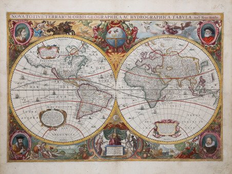

Nova Totius Terrarum Orbis Geographica Ac Hydrographica Tabula
Mode de Paiement
- PayPal
- Carte bancaire
- Virement bancaire
- Pubblica amministrazione
- Carta del Docente
Détails
- Année
- 1663
- Lieu d'édition
- Amsterdam
- Format
- 545 X 380
- Graveurs
- HONDIUS Hendrick
- Description
- Shirley, The Mapping of the World: Early Printed World Maps, 1472-1700, map 336;
Description
Splendido mappamondo in due emisferi, opera iconica dell'epoca d'oro della cartografia olandese. I cartigli abbelliti e le illustrazioni bizzarre fanno di questa mappa un eccellente esempio di cartografia in stile barocco. Circondata da scene mitiche e bestie fantastiche, la carta del mondo stessa include affascinanti illustrazioni di velieri, mostri marini e pesci. La carta è decorata nei quattro angoli con i ritratti di Claudio Tolomeo, Jodocus Hondius, Gerad Mercator e Giulio Cesare. Nella parte superiore è presente il globo celeste abbellito con festoni mentre, nella parte inferiore, la figura allegorica dell'Europa riceve doni dall'Africa, dall'Asia e dall'America, rappresentazione che riflette il dominio delle potenze marittime europee all'epoca. Ai lati sono raffigurati come di consueto i quattro elementi, Fuoco, Aria, Terra e Acqua. Nei due emisferi si possono notare inoltre tre piccoli pannelli, uno dei quali descrive la scoperta dell'America da parte di Cristoforo Colombo. Oltre alle numerose e splendide illustrazioni e ai dettagli cartografici, sono degne di nota alcune caratteristiche geografiche incluse in questa carta, come la California come isola, le reti fluviali e i laghi del Nord America e la linea costiera dell'Australia. Nel Sud America, lo Stretto di Le Maire appare ora ad est dello Stretto di Magellano. Lo Stretto di Le Maire era stato scoperto solo quindici anni prima della pubblicazione di questa mappa, quando Jacob Le Maire e Willem Schouten condussero una circumnavigazione per minare il monopolio commerciale della Compagnia olandese delle Indie Orientali (VOC). Le innovazioni riguardano anche la costa settentrionale dell'Australia che si estende verso la Nuova Guinea e un nuovo disegno del nord-est del Canada con l'Isola di Baffin (indicata come 'Queen Anne's forland') ora mostrata completamente circondata dal mare. L'inclusione della costa australiana in questa mappa traccia l'inizio della conoscenza olandese del continente australiano, quando la notizie di una "sconosciuta massa di terra ignota meridionale" si stava rapidamente diffondendo. Tra il 1630 e il 1666 sono state realizzate quattro versioni di questa carta; grazie alla sua popolarità, la mappa servì anche da base per altri cartografi. Il primo stato della mappa reca la data 1630; il secondo stato vede la data modificata in 1641 e l'aggiunta dell’imprint Amstelodami Excudit Ioannes Ianssonius in basso. Un terzo stato – come questo nostro esemplare - reca la data 1663 e un’ultima ristampa quella del 1666. ' Le prime due edizioni della carta del mondo di Hondius sono parte dell’Atlas Sive Cosmographicae Meditationes de Fabrica Mundi et Fabricati Figura, l'atlante di Mercator-Hondius, pubblicato per la prima volta dal padre del cartografo, Joducus Hondius, nel 1606. Jodocus acquistò le lastre dell'opera di Mercator, ristampandole ed integrandole con un numero sempre crescente di sue mappe. La terza edizione (1663) nell'Atlas Contractus ' di Jan Jansson e negli atlanti marittimi di Hendrick Van Loon. L’ultima stesura (1666) è invece parte dell’Atlas Major di Hannsonius. Il cartografo Hendrick [Henricus] Hondius (Amsterdam 1597-1651) era figlio del famoso Joducus Hondius, il cui ritratto appare in basso a sinistra. Mentre lavorava con il padre, Henricus fu determinante nell'espansione dell’Atlas Sive Cosmographicae Meditationes de Fabrica Mundi et Fabricati Figura. Alla morte del padre, nel 1612, Henricus e suo fratello, Jodocus il Giovane [Jodocus II Hondius], rilevarono l'attività calcografica. Nel 1621 aprì un proprio negozio, dove continuò a pubblicare nuove edizioni dell'atlante di Mercator. In seguito, collaborò con il cognato Jan [Johannes] Janssonius, con il quale continuò a sviluppare ed arricchire l’Atlas Sive Cosmographicae Meditationes de Fabrica Mundi et Fabricati Figura. Acquaforte, impressa su carta vergata coeva e finemente colorata a mano, con margini, lievi abrasioni restaurate visibili i. Stunning two-hemisphere world map, an iconic work from the golden age of Dutch cartography. Embellished cartouches and whimsical illustrations make this map an excellent example of Baroque-style cartography. Surrounded by mythical scenes and fantastic beasts, the world map itself includes fascinating illustrations of sailing ships, sea monsters, and fish. The map is decorated in the four corners with portraits of Claudius Ptolemy, Jodocus Hondius, Gerad Mercator and Julius Caesar. The upper part features the celestial globe embellished with festoons while, in the lower part, the allegorical figure of Europe receives gifts from Africa, Asia and America, a depiction reflecting the dominance of European maritime powers at the time. On the sides are depicted as usual the four elements, Fire, Air, Earth and Water. The two hemispheres also feature three small panels, one of which depicts the discovery of America by Christopher Columbus. In addition to the many beautiful illustrations and cartographic details, some geographical features included in this map are noteworthy, such as California as an island, the river networks and lakes of North America, and the coastline of Australia. In South America, the Strait of Le Maire now appears east of the Strait of Magellan. The Strait of Le Maire had only been discovered fifteen years before the publication of this map, when Jacob Le Maire and Willem Schouten conducted a circumnavigation to undermine the Dutch East India Company's (VOC) trade monopoly. Innovations also include the northern coast of Australia extending toward New Guinea and a new drawing of northeastern Canada with Baffin Island (referred to as 'Queen Anne's forland') now shown completely surrounded by sea. The inclusion of the Australian coast in this map traces the beginning of Dutch knowledge of the Australian continent, when news of an "unknown southern land mass" was rapidly spreading. Four versions of this map were made between 1630 and 1666; due to its popularity, the map also served as a basis for other cartographers. The first state of the map bears the date 1630; the second state sees the date changed to 1641 and the addition of the imprint Amstelodami Excudit Ioannes Ianssonius at the bottom. A third state - as this example - bears the date 1663 and a final reprint that of 1666. ' The first two editions of Hondius' world map are part of the Atlas Sive Cosmographicae Meditationes de Fabrica Mundi et Fabricati Figura, the Mercator-Hondius atlas first published by the cartographer's father, Joducus Hondius, in 1606. Jodocus acquired plates of Mercator's work, reprinting and supplementing them with an increasing number of his maps. The third edition was included (1663) in Jan Jansson's Atlas Contractus and Hendrick Van Loon's maritime atlases. The last issue (1666), on the other hand, is part of Jannsonius's Atlas Major. The cartographer Hendrick [Henricus] Hondius (Amsterdam 1597-1651) was the son of the famous Joducus Hondius, whose portrait appears at lower left. While working with his father, Henricus was instrumental in the expansion of the Atlas Sive Cosmographicae Meditationes de Fabrica Mundi et Fabricati Figura. When his father died in 1612, Henricus and his brother, Jodocus the Younger [Jodocus II Hondius], took over the intaglio business. In 1621 he opened his own store, where he continued to publish new editions of Mercator's atlas. Later, he collaborated with his brother-in-law Jan [Johannes] Janssonius, with whom he continued to develop and enrich the Atlas Sive Cosmographicae Meditationes de Fabrica Mundi et Fabricati Figura. Etching, printed on contemporary laid paper and finely hand-colored, in very good condition. Example of the third state of four with the date 1663 and the imprint Amstelodami Excudit Ioannes Ianssonius. Bibliografia Rodney W. Shirley, The Mapping of the World: Early Printed World Maps, 1472-1700, (Riverside, CT: Early World Press, 2001), map 336; Glen McLaughlin with . Cfr.