Nova Virginiae Tabula
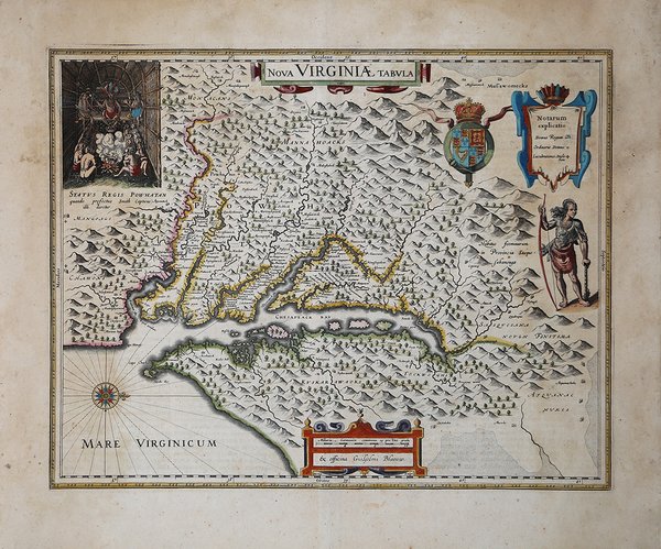

Nova Virginiae Tabula
Mode de Paiement
- PayPal
- Carte bancaire
- Virement bancaire
- Pubblica amministrazione
- Carta del Docente
Détails
- Année
- 1629
- Lieu d'édition
- Amsterdam
- Format
- 480 X 378
- Graveurs
- BLAEU Willem Janszoon
Description
La mappa ha la sua principale fonte nel primo stato dell’opera realizzata da Smith nel 1612, sebbene sia leggermente più larga e più finemente incisa. Nel 1629 la lastra di Hondius venne acquistata da Blaeu il quale ne cancellò il nome per sostituirlo con il suo, da cui il secondo stato.La mappa è conosciuta anche per la sua rappresentazione, in alto a destra, di Capo Powhatan, che agita la sua pipa mentre è seduto, come recita la didascalia, come quando il capitano John Smith veniva condotto da lui come prigioniero. Smith non era solito servirsi dell’assistenza dei nativi per aggiungere informazioni alle sue opera. Questa mappa rappresenta la prima versione ampiamente diffusa dell'opera di Smith e, conseguentemente, importante riferimento per le altre mappe dell'epoca, tanto da divenire modello della regione fino alla pubblicazione dell'opera di Augustine Hermanns nel 1673.L’opera è una delle rappresentazioni più dettagliate della regione del Chesapeake, apprezzata dai collezionisti di mappe della zona. Bibliografia: Burden 193. Editione latina dal atlante di Blaeu. Willem Janszoon Blaeu, avviò nel 1599 la sua attività di costruttore di globi e strumenti astronomici ad Amsterdam. Nel 1630, dopo aver comprato alcune lastre dell’atlante del Mercator da Jodocus Hondius II, fu in grado di pubblicare un volume di 60 mappe con il titolo di ' Atlantis Appendix. Cinque anni dopo, pubblicò i primi due volumi del suo atlante ' Atlas Novus ' o ' Theatrum Orbis Terrarum, ' in sei libri. Dopo la sua morte, Joan (Johannes) continuò l’opera paterna, completando l’intera serie di sei volume dell’Atlas Novus ' intorno al 1655. Fu inoltre autore di un ' Atlas Maior sive Cosmographia Blaviana, in 12 volumi pubblicati nel 1662 -72. Incisione in rame, bella coloritura coeva, in ottimo stato di conservazione. The map is based on the first state of Smith's map, 1612, and is slightly larger and more expertly engraved. In 1629 the Hondius plate was purchased by Blaeu who deleted Hondius' name and added his own to the imprint, constituting the second state. The map is, in part, famous for its depiction, upper left, of Chief Powhatan, waving his tobacco pipe, and seated, as the caption says, in state when Capt. John Smith was delivered to him prisoner . Smith was unusual among early mapmakers in acknowledging the assistance of native American informants. This map was the first widely disseminated version of the Smith map and therefore higly influential on other maps of the period and became the standard map of the region until Augustine Hermanns map of 1673. The map is one of the most detailed map of the Chesapeake region to date and is an essential map for collectors of this region. Bibliografia: Burden 193. Latin text edition. Willem Janszoon Blaeu, started in 1599 his business as a builder of globes and astronomical instruments in Amsterdam. In 1630, after buying some plates of the Mercator atlas from Jodocus Hondius II, he was able to publish a volume of 60 maps under the title ' Atlantis Appendix. Five years later, he published the first two volumes of his atlas ' Atlas Novus ' or ' Theatrum Orbis Terrarum, in six books. After his death, Joan (Johannes) continued his father's work, completing the entire six-volume ' Atlas Novus ' series around 1655. He was also the author of an ' Atlas Maior sive Cosmographia Blaviana, in 12 volumes published in 1662 -72. Copperplate, with fine original colour, good condition. Cfr.