Parallelo Geografico dell'Antico col Moderno Arcipelago. / Parte Meridionale dell'Arcipelago
Parallelo Geografico dell'Antico col Moderno Arcipelago. / Parte Meridionale dell'Arcipelago | Gravures | CORONELLI Vincenzo
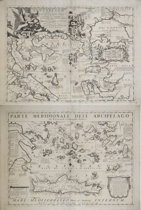
Parallelo Geografico dell'Antico col Moderno Arcipelago. / Parte Meridionale dell'Arcipelago
Parallelo Geografico dell'Antico col Moderno Arcipelago. / Parte Meridionale dell'Arcipelago | Gravures | CORONELLI Vincenzo
Mode de Paiement
- PayPal
- Carte bancaire
- Virement bancaire
- Pubblica amministrazione
- Carta del Docente
Détails
- Année
- 1690
- Lieu d'édition
- Venezia
- Format
- 620 X 870
- Graveurs
- CORONELLI Vincenzo
Description
Bellissima grande carta geografica che mostra l’Arcipelago greco e anche parte dell’Asia Minore e Turchia nordoccidentale, connessa al Mar Nero attraverso lo Stretto del Bosforo e al Mar Egeo con lo Stretto dei Dardanelli. La carta è stampata su 2 fogli con grande cartiglio decorativo in alto dell'Arcipelago settentrionale con il Leone di Venezia a sinistra e i Turchi sconfitti a destra in scala all'interno di una ghirlanda decorativa. l'Arcipelago meridionale con il titolo [Partie Meriodionale dell'Archipelago.] in alto [sarebbe coperto se i 2 fogli fossero uniti]. Inscrizione su drappo dedicato all'isola di Creta per ricordare i "diversi nomi e proprietari". Un'altra tavola elenca le vittorie ottenute dai Veneziani, di cui più in basso, ricordati i "Luoghi che la Repubblica ha dominio nell'Arcipelago"; due stemmi a mare. La carta è ricca di informazioni storiche, poste accanto alle rispettive isole, che forniscono varianti di toponimi o annessioni. Opera tratta dal ' Corso geografico universale, o sia la terra divisa nelle sue parti e subdistinta ne' suoi gran regni. Esposta in tavole geografiche ricorrette et accresciute di tutte le nuove scoperte, ad uso dell'Accademia Cosmografica degli Argonauti dal Padre Maestro Vincenzo Coronelli M. C. Cosmografo della Serenissima Republica di Venetia. Dedicata alla Santità di Nostro Signore Innocenzo XII. P. I. In Venetia, a spese dell'autore. MDCXCII. Coronelli visse un periodo di straordinaria fecondità editoriale a partire dal 1689, quando ebbe la cattedra di geografia presso l'Università alle Procuratie, con la pubblicazione, nel 1690, del primo volume dell'Atlante Veneto. In effetti sotto il nome di ' Atlante Veneto ' va tutta la raccolta di tredici opere composte nell'arco del decennio successivo, dall'Isolario ' allo ' Specchio del mare. In realtà solo alcune di tali opere possono definirsi atlante, e sono di valore molto disuguale, dato che si passa da opere originali e fondamentali come quelle citate o il ' Corso Geografico ' ad opere di compilazione o semplici raccolte di vedute. Il ' Corso Geografico ' uscì in diverse edizioni con numeri diversi di carte - sessantotto tavole nel 1689-92; di centosettantatré tavole nel 1692; duecentosessanta tavole, nel 1694-97 - che venivano vendute anche separatamente, al ritmo di sei carte al mese per due anni. Le carte furono incise tra il 1688 e il 1692 nell'attrezzatissima officina cartografica del convento dei Frari, dove lavoravano anche incisori stranieri. ' Incisione in rame, in ottimo stato di conservazione. ' Due fogli da 620x460 mm [qualora unita misurerebbe 870x 620mm]. Beautiful large map showing the Greek Archipelago and also part of Asia Minor and northwestern Turkey, connected to the Black Sea by the Bosporus Strait and to the Aegean Sea by the Dardanelles Strait. The map is printed on 2 sheets with large decorative title cartouche to upper Northern Archipelago with the Lion of Venice to the left and defeated Turks to the right scale within decorative garland . the Southern Archipelago with title [ ' Partie Meriodionale dell'Archipelago.] across the top [would be covered if the 2 sheets are joined]. Inscriprion on banner dedicated to the island of Crete to remember the "different names and owners." Another table lists the victories won by the Venetians, whose further down, remembered the "Places that the Republic has dominion in the Archipelago" ;two coats of arms to sea. The map is full of historical information, placed next to the respective islands, providing variants of place names or annexations. ' The map is taken from ' Corso geografico universale, o sia la terra divisa nelle sue parti e subdistinta ne' suoi gran regni. Esposta in tavole geografiche ricorrette et accresciute di tutte le nuove scoperte, ad uso dell'Accademia Cosmografica degli Argonauti dal Padre Maestro Vincenzo Coronelli M. C. Cosmografo della Serenissima Republica di Venetia. Dedicata alla Santità di Nostro Signore Innocenzo XII. P. I. In Venetia, a spese dell'autore. MDCXCII. Coronelli lived a period of extraordinary editorial fecundity starting from 1689, when he had the chair of geography at the University at the Procuratie, with the publication, in 1690, of the first volume of the ' Atlante Veneto. Under the name of ' Atlante Veneto ' goes the entire collection of thirteen works composed over the next decade, from the ' Isolario ' to the ' Specchio del mare. ' Only some of these works can be defined as atlas, and are of very unequal value, since we go from original and fundamental works such as those mentioned or the ' Corso Geografico ' to works of compilation or simple collections of views. The ' Corso Geografico ' came out in several editions with different numbers of maps - sixty-eight maps in 1689-92; one hundred and seventy-three maps in 1692; two hundred and sixty maps in 1694-97 - which were also sold separately, at the rate of six a month for two years. The maps were alle engraved between 1688 and 1692 in the well-equipped cartographic workshop of the Frari convent, where foreign engravers also worked. ' Copperplate, very good condition. ' Two sheets of ' 620x460 mm [if joined would be 870x 620mm]. ' Cfr. Zacharakis:1037/670 &1038/671.
