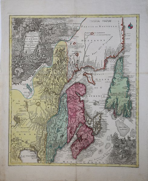
Parte Orientale de la Nouvelle France ou de Canada….
Parte Orientale de la Nouvelle France ou de Canada…. | Gravures | SEUTTER "il vecchio" Matthaus

Parte Orientale de la Nouvelle France ou de Canada….
Parte Orientale de la Nouvelle France ou de Canada…. | Gravures | SEUTTER "il vecchio" Matthaus
Mode de Paiement
- PayPal
- Carte bancaire
- Virement bancaire
- Pubblica amministrazione
- Carta del Docente
Détails
- Année
- 1745
- Lieu d'édition
- Augsburg
- Format
- 505 X 580
- Graveurs
- SEUTTER "il vecchio" Matthaus
Description
Bella e insolita mappa del norest del Canada, con Nuova Scozia, Labrador e Terranova. Questo è il secondo stato della mappa disegnata da Seutter e incisa da Lotter, con l'imprint di Lotter. La mappa ha una forma allungata che distorce il territorio di Terranova. La carta è molto dettagliata, soprattutto lungo le coste e nell'idrografia. In alto, a destra, è una grande cartiglio decorativo con figure allegoriche, capi indiani, esploratori ecc. Matthäus Seutter (1678 - 1757) fu uno dei più importanti e prolifici editori tedeschi di mappe del XVIII secolo. Attivo, come incisore sotto la tutela dell'importante J. B. Homann. All'inizio del 1700 Seutter lasciò Homann per tornare ad Augusta, dove lavorò per l'importante editore d'arte Jeremia Wolff (1663 - 1724), per il quale incise mappe e altre stampe. Intorno al 1717 fondò la propria casa editrice cartografica indipendente ad Augusta. La maggior parte delle mappe di Seutter sono pesantemente basate, se non addirittura copie, di lavori precedenti fatti dalle calcografie Homann e De L'Isle. Ciononostante, dal 1731/32 Seutter era uno degli editori più prolifici del suo tempo e fu onorato dall'imperatore tedesco Carlo VI che gli diede il titolo di Geografo Imperiale, dopo il quale la maggior parte delle mappe successive includeva la denominazione ' Avec Privilege. ' Seutter continuò a pubblicare fino alla sua morte, all'apice della sua carriera, nel 1757. Incisione in rame, coloritura coeva, in buone condizioni. Very unusual elongated map of the East coast of Canada. A beautiful map of Northeastern Canada, including Nova Scotia, Labrador and Newfoundland. This is the second state of the map originally drawn by Seutter and engraved by Lotter, with Lotter's imprint. The map's vertical format elongates the geography and distorts Newfoundland. The St. Lawrence River runs nearly north-south. It is very detailed, especially along the coastlines and rivers. Many place names, both European and Indian. At bottom right is a scene with several sailing ships. At top left is a huge decorative title cartouche featuring allegorical figures, Indian chiefs, explorers, mapmakers, a fleet of ships, fishermen and wildlife. Mattha?us Seutter (1678 - 1757) was one of the most important and prolific German map publishers of the 18th century. Seutter was born the son of a goldsmith but apprenticed as a brewer. Apparently uninspired by the beer business, Seutter abandoned his apprenticeship and moved to Nuremberg where he apprenticed as an engraver under the tutelage of the prominent J. B. Homann. Sometime in the early 1700s Seutter left Homann to return to Augsburg, where he worked for the prominent art publisher jeremiad Wolff (1663 - 1724), for whom he engraved maps and other prints. Most of Seutter's maps are heavily based upon, if not copies of, earlier work done by the Homann and De L'Isle firms. Nonetheless, by 1731/32 Seutter was one of the most prolific publishers of his time and was honored by the German Emperor Karl VI who gave him the title of Imperial Geographer, after which most subsequent maps included the Avec Privilege designation. Copperplate, original colour, in good condition. Cfr.
