Peru
Peru | Gravures | Laet Johannes de
Peru
Peru | Gravures | Laet Johannes de
Mode de Paiement
- PayPal
- Carte bancaire
- Virement bancaire
- Pubblica amministrazione
- Carta del Docente
Détails
- Année
- 1630
- Lieu d'édition
- Amsterdam
- Format
- 360 X 285
- Graveurs
- Laet Johannes de
Description
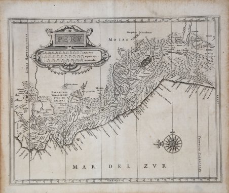
Importante carta del Perù, una delle prime mappe ottenibili incentrate sulla regione e la prima a basarsi sul lavoro di Hessel Gerritsz. Questa notevole carta precede le mappe del Perù pubblicate da Blaeu e Jansson. La mappa fu pubblicata a Leida nel 1630 come parte della Nieuwe Wereldt often Beschrijvinghe van West-Indien (Descrizione delle Indie Occidentali) di Johannes de Laet. L'opera era stata pubblicata originariamente nel 1625 e conteneva dieci mappe; questa è la versione leggermente aggiornata che conteneva quattordici mappe e 100 pagine di testo in più, a testimonianza del crescente interesse degli olandesi per il Nuovo Mondo. Descritte da Philip Burden come "probabilmente la più bella descrizione delle Americhe pubblicata durante il XVII secolo", le mappe dell'opera di de Laet si basavano direttamente sulla cartografia di Hessel Gerritsz, considerato da alcuni il principale cartografo dell'età d'oro della cartografia olandese. Gerritsz era il cartografo esclusivo della Compagnia olandese delle Indie orientali e aveva accesso ad alcune delle informazioni più aggiornate disponibili. Le sue mappe sono generalmente disponibili solo in forma manoscritta e quelle pubblicate da de Laet sono alcune delle poche disponibili per i collezionisti di oggi. Anche Johannes de Laet non era uno sprovveduto e per la compilazione dei suoi dati geografici si avvalse di ricerche meticolose e di fonti contemporanee. In qualità di direttore della neonata Compagnia Olandese delle Indie Occidentali, per la compilazione delle mappe avrebbe utilizzato anche le informazioni più recenti provenienti dalla corrispondenza privata, dai manoscritti e da altri segreti aziendali. Acquaforte, in ottimo stato di conservazione. Important early map of Peru, one of the earliest obtainable maps to focus on the region and the first to rely upon the work of Hessel Gerritsz. This remarkable early map pre-dates the maps of Peru issued by Blaeu and Jansson. The map was published in Leiden in 1630 as part of Johannes de Laet’s ' Nieuwe Wereldt often Beschrijvinghe van West-Indien ' (Description of the West Indies). The work was originally issued in 1625 and contained ten maps – this is from the slightly updated version that contained fourteen maps and an additional 100 pages of text, reflecting the increased interest of the Dutch in the New World. Described by Philip Burden as “arguably the finest description of the Americas published during the seventeenth century,” the maps in de Laet’s work were based directly off the cartography of Hessel Gerritsz, considered by some to be the foremost mapmaker of the Dutch Golden Age of Cartography. Gerritsz was the exclusive cartographer for the Dutch East India Company and had access to some of the most up-to-date information available. His maps are generally only available in manuscript form and those published by de Laet are some of the few available to collectors today. Johannes de Laet was no slouch, either, and he used meticulous research and contemporary sources when compiling his geographic data. As a director of the newly formed Dutch West India Company, the latest information from private correspondence, manuscripts, and other company secrets would have also been made available when compiling the maps. Etching, very good condition. Rare. Cfr.
